Faircrest Heights, Los Angeles
Faircrest Heights is a neighborhood in Mid-City, Los Angeles, California.[1]
Faircrest Heights | |
|---|---|
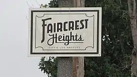 Faircrest Heights Signage located at the intersection of Fairfax Avenue and Airdrome. | |
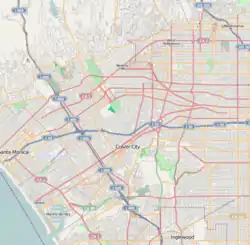 Faircrest Heights Location within Los Angeles | |
| Coordinates: 34°02′46″N 118°22′16″W | |
| Country | |
| State | |
| County | |
| Time zone | Pacific |
| Zip Code | 90035 |
| Area code(s) | 323 |
In December 2004, Los Angeles magazine named Faircrest Heights one of the "10 Best Districts You've Never Heard Of".[2]
Geography
Los Angeles Magazine
In December 2004, Los Angeles Magazine bounded the neighborhood as La Cienega Boulevard on the west, Fairfax Avenue on the east, Pico Boulevard on the north and Guthrie Street on the south. It lay south of South Carthay, Los Angeles.[2]
P.I.C.O. Neighborhood Council
The P.I.C.O. Neighborhood Council map does not indicate a neighborhood called Faircrest Heights. Instead, the council breaks the area into two residential districts: “Neighbors United” and “C.H.A.P.S.” [3][4] Per the council bylaws, the two combined residential districts are bounded by La Cienega Boulevard on the west; Fairfax Avenue on the east; Pico Boulevard on the north; and David Avenue and Venice Boulevard on the south.[5]
Google Maps
According to Google Maps, Faircrest Heights is bounded by Alvira Street on the west, Fairfax Avenue on the east, Pico Boulevard on the north and Sawyer Street on the south.[6][lower-alpha 1]
Adjacent neighborhoods
Crestview and La Cienega Heights are located to the west; Reynier Village is located to the southwest; Carthay Square, Little Ethiopia, and South Carthay neighborhoods are to the north; and Picfair Village is located to the east. The Culver City Arts District is located to the south.
Demographics
Based on the 2010 Census, within the five census block groups that compose Faircrest Heights, racial representation is mixed with approximately 38% white, 37% African American, 8% Asian, and 18% other.[7] The housing stock was primarily built in the late 1920s to early 1940s,[8] and consists of primarily Spanish Colonial Revival, English Revival, and Minimal Traditional style single family residences, with some small apartment buildings (mostly in the areas north of Pickford Street).
References
- Emily Alpert Reyes, "Houses Bigger, But Better?" Los Angeles Times, May 5, 2014, image 9
- Los Angeles Magazine. Emmis Communications. June 2002. p. 84. ISSN 1522-9149. Retrieved 2014-12-10.
- "P.I.C.O. Neighborhood Council - Neighbors United". Retrieved 3 July 2018.
- "P.I.C.O. Neighborhood Council - C.H.A.P.S." Retrieved 3 July 2018.
- "P.I.C.O. Neighborhood Council Bylaws". Retrieved 3 July 2018.
- Google (7 September 2017). "The Faircrest Heights Neighborhood as indicated on Google Maps" (Map). Google Maps. Google. Retrieved 7 September 2017.
- "2010 Census Interactive Population Map". Retrieved 28 June 2018.
- "LA County Property Assessment Information System". Retrieved 28 June 2018.
Notes
- Where other reliable sources are available for the boundaries of neighborhoods, they should be treated preferentially to Google Maps and Google Street View. It is difficult if not impossible to verify as they are subject to change and documentation and archives are not available.