Beverly Grove, Los Angeles
Beverly Grove is a neighborhood within the Beverly–Fairfax neighborhood in the Mid-City West area of Los Angeles, California.[1][2][3]
Geography
City of Los Angeles
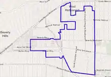
The term "Beverly Grove" was first used in 2006 to unofficially refer to an area that was proposed to be subject to an anti-mansionization ordinance.[4][5] It referred to an area in the Wilshire Community Plan area[6] that is generally bounded by Colgate Avenue on the north, Fairfax Avenue on the east, Lindenhurst Avenue on the south, and San Vicente Boulevard on the west.[4][7][8]
Los Angeles Times' Mapping L.A. boundaries
In a departure from its first draft, the Los Angeles Times Mapping L.A. project maps Beverly Grove as bounded on the north and west by the West Hollywood and Beverly Hills city limits, on the east by Fairfax Avenue and on the south by Wilshire Boulevard and San Vicente Boulevard.
It abuts the city limits of Beverly Hills to the west, West Hollywood to the north, Fairfax and Mid-Wilshire to the east, and Carthay to the south.[9][10][11]
In the first draft of Mapping L.A., "Beverly Grove" was not included as a distinct neighborhood; rather, the area was shown as part of the Fairfax District.[12] The Times database editor and its map project's coordinator later acknowledged in 2014 that "Beverly Grove" had not been a well established name.[13][14]
History
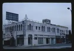
According to the Los Angeles Conservancy, Beverly Grove was built primarily in the 1920s and has a "combination of quiet charm and close proximity to shopping, restaurants, and museums".[15]
In 2008, the city adopted ordinance 182754 which amended Section 12.04 of the Los Angeles Municipal Code by amending the zoning map because "the area unofficially known as Beverly Grove (located in the Wilshire Community Plan and generally bounded by Colgate Avenue on the north, Fairfax Avenue on the east, Lindenhurst Avenue on the south, and San Vicente Boulevard on the west) continues to experience out-of-scale development with a noticeable increase in demolitions and the construction of new single-family dwellings. A Residential Floor Area Supplemental Use District (RFA) was created to "in order to ensure that new development matches the scale and character of existing buildings in the surrounding area".
Demographics
The following data applies to the boundaries set by Mapping L.A.:
The 2000 U.S. census counted 21,417 residents in the 1.65-square-mile neighborhood—an average of 12,990 people per square mile, fairly normal for Los Angeles. In 2008, the city estimated that the population had increased to 22,855. The median age for residents was 38, old for both the city and the county.[9]
The percentage of white people living in the area was 82%. Other ethnicities in 2000 were Latinos, 6%; Asians, 5,1%; blacks, 2%; and others, 4.9%. Iran (20.2%) and Poland (7.4%) were the most common places of birth for the 36.3% of the residents who were born abroad, a figure that was considered average for the city as a whole.[9]
The median household income in 2008 dollars was $63,039. The average household size of 1.7 people was low for Los Angeles. Renters occupied 74.8% of the housing units, and house or apartment owners the rest.[9]
The percentages of never-married men and women, 53.2% and 40.5%, respectively, were among the county's highest.[9]
Education
Half of Beverly Grove residents aged 25 and older possessed a four-year degree in 2000, a high rate for both the city and the county. The percentage of residents with a master's degree was also high.[9]
Perutz Etz Jacob Hebrew Academy, a private elementary school at 7951 Beverly Boulevard, was the only school operating in the neighborhood.[16]
Notable places
- The Beverly Center. Opened in 1982 by developers A. Alfred Taubman, Sheldon Gordon and E. Phillip Lyon, it features various designer stores and restaurants. The site's former occupant was a small amusement park known as Beverly Park.
- Edinburgh Bungalow Court: Spanish Colonial Revival complex, Los Angeles historic-cultural monument No. 1105 designated in 2016 on the corner of Edinburgh and Waring avenues.[17][18]
- Third Street shopping district. Located between Fairfax and La Cienega.
References
- "Case No. CHC-2017-2886-HCM / Council File: 17-1213" (PDF).
- Beverly Grove RFA Ordinance
- "Historic Resources Survey Report: Wilshire Community Plan Area" (PDF).
- Motion by Jack Weiss, Councilmember, 5th District, February 24, 2006. "An ordinance imposing interim regulations on the issuance of building permits on any R1-zoned lot fronting on and within the area generally bounded by Colgate Avenue on the north, Fairfax Avenue on the east, Lindenhurst Avenue on the south, and San Vicente Boulevard on the west, hereby unoffcially referred to as 'Beverly Grove' in the Wilshire Community Plan Area."
- Council File: 06-0400, LACityClerk Connect.
- "Wilshire Community Plan". City of Los Angeles.
- "Data" (PDF). clkrep.lacity.org. Retrieved 2020-07-31.
- Ordinance No. 182754, Council of the City of Los Angeles, October 18, 2013.
- "Beverly Grove," Mapping L.A., Los Angeles Times
- "Central L.A.," Mapping L.A., Los Angeles Times
- "Westside," Mapping L.A., Los Angeles Times
- "Mapping L.A. - Los Angeles Times". maps.latimes.com.
- Kareem Maddox (2014-04-09). "What's in a name? The quest for 'Beverly Village'". KCRW.
- February 20, Kevin Roderick; Am, 2009 9:14. "Neighborhood project is up *". LA Observed.CS1 maint: numeric names: authors list (link)
- "Fighting Mansionization in Beverly Grove | Los Angeles Conservancy". www.laconservancy.org.
- "Beverly Grove Schools," Mapping L.A., Los Angeles Times
- Lelyveld, Nita (2020-01-18). "Are you a fan of old L.A.'s charm? These historic bungalows need a savior with deep pockets". Los Angeles Times. Retrieved 2020-01-19.
- "Edinburgh Bungalow Court | Los Angeles Conservancy". www.laconservancy.org.
External links
- Los Angeles Times: Beverly Grove map and statistics
- Los Angeles Times: Beverly Grove crime map and statistics
| By topic |  | |
|---|---|---|
| Government | ||