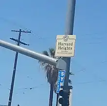
Harvard Heights, Los Angeles
Harvard Heights is a densely populated, mixed-income neighborhood of 20,000+ people in Central Los Angeles, California. Within it lies a municipally designated historic overlay zone designed to protect its architecturally significant single-family residences, including the only remaining Greene and Greene house in Los Angeles.
Harvard Heights | |
|---|---|
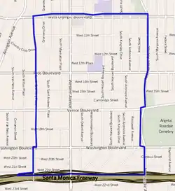 Harvard Heights, as delineated by the Los Angeles Times | |
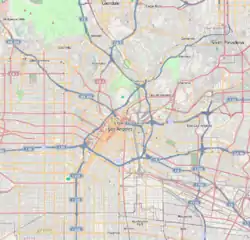 Harvard Heights Location within central Los Angeles | |
| Coordinates: 34°2′36″N 118°18′15″W |
The neighborhood has one private and two public schools. It is the site of a private library dedicated to the memory of singer Ray Charles.
Geography
Description
Harvard Heights is a neighborhood between Western and Normandie Avenues and Pico and Washington Boulevards. It is part of the West Adams district, a middle-class area annexed by the city of Los Angeles early in the century. Two-story Craftsman-style homes still abound there.
Since 2000, the City of Los Angeles Planning Department and Office of Historic Resources[1] has defined the Harvard Heights HPOZ (Historic Preservation Overlay Zone) as encompassing 34 blocks comprised predominantly of single-family residences, some multiple-family residences, as well as commercial properties.[2] The designated historic zone lies between Pico Boulevard on the north, Santa Monica Freeway to the south, Normandie Avenue on the east and Western Avenue on the west.[2][3] This HPOZ includes both the neighborhood of Harvard Heights to the north of Washington Boulevard and the neighborhood of West Adams Heights/Sugar Hill to the south of Washington Boulevard.[4][5]
The Mapping L.A. project of the Los Angeles Times erroneously defines Harvard Heights as a broader area, flanked by Koreatown to the north, Pico-Union to the east, Adams-Normandie and Jefferson Park to the south and Arlington Heights to the west. The street boundaries are given as north: Olympic Boulevard; east: Normandie Avenue; south: Washington Boulevard; and west: Western Boulevard.[6][7][8]
Architecture
Harvard Heights has been noted as a
once grand neighborhood that was in danger of falling apart. ... The overall population was old and largely African American as whites migrated to the suburbs, the freeway bisected the neighborhood, and most of the homes had been converted into apartments. ... [but the] neighborhood's long-anticipated renaissance took place in the late '90s. As Los Angeles commutes got longer and longer, white-collar professionals began moving back into the city.[9]
Harvard Heights has been called a "preservationist's dream come true," a neighborhood characterized by the Craftsman houses built on the heights southwest of downtown, primarily between 1902 and 1910. Today, Harvard Heights boasts the only remaining Greene and Greene house (Historic Cultural Monument #991) in Los Angeles, "as well as homes built by the Heinemann brothers (Historic Cultural Monument #818), Hunt and Eager, and especially architect Frank M. Tyler."[10]
According to a 2005 Los Angeles Times headline, Harvard Heights was "a stately turn-of-the-century neighborhood that has been undergoing a restoration boom after decades of hard times. [The] [e]xquisite woodwork, high ceilings, formal dining rooms, cozy inglenooks and stained-glass windows are some of the features that attract residents to [the] spacious two-story homes" found in the area."[10]
In 2005 it was said that "Although prices are rising steadily, Harvard Heights remains an affordable choice for people interested in large historic homes. Two-story homes here are a relative bargain when the square footage and features are compared with similarly priced structures in other neighborhoods."[10]
Exquisite woodwork, high ceilings, formal dining rooms, cozy inglenooks and stained-glass windows are some of the features that attract residents to these spacious two-story homes. For those who work downtown, the area's proximity to the city and the Santa Monica Freeway make it an easy commute.[10]
The architecture of the neighborhood has also made the area a favorite for film and television location scouts.[9][10]
Population
According to the Mapping L.A. project of the Los Angeles Times, the 2000 U.S. census counted 18,587 residents in the 0.79-square-mile neighborhood—an average of 23,473 people per square mile, one of the highest densities in Los Angeles. In 2008 the city estimated that the population had increased to 20,194. The median age for residents was 30, about the same as the city norm.[7]
Harvard Heights was considered moderately diverse ethnically. In 2000, The breakdown was Latinos, 66.3%; Asians, 13.3%; blacks, 16%, whites, 3.3%; and others, 1.2%. Mexico (32.9%) and El Salvador (24.8%) were the most common places of birth for the 57.8% of the residents who were born abroad, a figure that was considered high compared to the city as a whole.[7]
The median household income in 2008 dollars was $31,173, a low figure for Los Angeles, and a high percentage of households earned $20,000 or less. The average household size of 3.2 people was high for the city of Los Angeles. Renters occupied 84.3% of the housing units, and house- or apartment owners the rest.[7]
The percentages of never-married men and women, 50% and 48,2%, respectively, were among the county's highest. The 2000 census found 939 families headed by single parents, a high rate for both the city and the county. There were 501 military veterans in 2000, or 3.8%, a low figure for Los Angeles.[7]
These were the ten neighborhoods or cities in Los Angeles County with the highest population densities, according to the 2000 census, with the population per square mile:[11]
- Koreatown, Los Angeles, 42,611
- Westlake, Los Angeles, 38,214
- East Hollywood, Los Angeles, 31,095
- Pico-Union, Los Angeles, 25,352
- Maywood, California, 23,638
- Harvard Heights, Los Angeles, 23,473
- Hollywood, Los Angeles, 22,193
- Walnut Park, California, 22,028
- Palms, Los Angeles, 21,870
- Adams-Normandie, Los Angeles, 21,848
Education
Just 10.3% of Harvard Heights residents aged 25 and older had a four-year degree in 2000, a low rate for both the city and the county. The percentage of residents with less than a high school diploma was high for the county.[7]
Schools operating within the Harvard Heights borders are:[12]
Developments
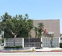
In September 2010, the original site of singer Ray Charles's recording studio and office on Washington Blvd (Historic Cultural Monument #776), was rededicated as the Ray Charles Memorial Library.[15] The Library contains exhibit space including memorabilia, awards, and interactive music displays of the famous musician.[15]
In February 2013, the often filmed Spanish Colonial revival themed Pacific Bell Building (Historic Cultural Monument #331) was rehabilitated for adaptive reuse and reopened as the Jane B. Eisner charter middle school in the middle of the Harvard Heights neighborhood.[16]
In 2013, the Los Angeles Neighborhood Initiative, in partnership with the City of Los Angeles and local stakeholders, was scheduled to break ground on the Normandie Cordova Public Park project, located on the current vacant land at the west side of the intersection of Normandie and Cordova. This pocket park project is expected to amplify the community friendly green space, and will include recreational spaces for both adults and children in the Harvard Heights neighborhood.[17]
Business and commerce
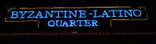
The Byzantine Latino Quarter Business Improvement District (BLQ BID)[18][19] was created in 2003 by the Los Angeles City Council with support from community stakeholders and property owners in an effort to beautify the business corridor and create a safe and business-friendly environment.[20] The BLQ BID includes approximately 243 property parcels. The Los Angeles Neighborhood Initiative organization is primarily responsible for the beautification, maintenance and marketing efforts of the business district.[21]
Notable residents
- William M. Hughes, Los Angeles City Council member, 1927–29[22][23]
- Edward Trinkkeller, master ironworker and designer of the gates at Hearst Castle[10]
- Frank M. Tyler, architect[24]
- Lovie Yancey, founder of the Fatburger hamburger chain[25]
References
- City document
- "Harvard Heights Historic Preservation Plan," December 2010 edition, page 17
- Harvard Heights survey map
- http://www.westadamsheightssugarhill.com/AboutUs.html
- https://nextdoor.com/map/
- "Central L.A.," Mapping L.A., Los Angeles Times
- "Harvard Heights," Mapping L.A., Los Angeles Times
- The Thomas Guide, 2006, page 633
- Roberts, Gretchen. "Star Treatment: A Picture-Perfect Hollywood Craftsman". Old House Journal. Archived from the original on 27 August 2013. Retrieved 2 June 2013.
- Danny Miller, "Saving Harvard Heights," Los Angeles Times, September 11, 2005
- "Population Density". Los Angeles Times. Mapping L.A. Retrieved June 12, 2016.
- "Harvard Height Schools," Mapping L.A., Los Angeles Times
- Jane B. Eisner School Announcement . Retrieved on 2 June 2013.
- "Jane B. Eisner Middle School - Los Angeles - Brugklas". Facebook. Retrieved 2013-10-04.
- "FAQs". The Ray Charles Memorial Library. 2010-09-23. Retrieved 2013-10-04.
- Pacific Bell Building Adaptive Reuse Project
- LANI Statewide Park Program proposal, with photos
- Byzantine Latino Quarter Website
- Usher, Nikki (12 August 2004). "Where Spanakopita Rubs Elbows With Chile Relleno". Los Angeles Times. Retrieved 2 June 2013.
- "Los Angeles Neighborhood Initiative Projects". Archived from the original on 2013-10-04. Retrieved 2013-03-19.
- "Los Angeles Neighborhood Initiative". Lani.org. Archived from the original on 2013-10-04. Retrieved 2013-10-04.
- "The Watchman," Los Angeles Times, April 24, 1927, page B-2
- Location on "Mapping L.A."
- Danny Miller, "Saving Harvard Heights: Old College Try Works," The Los Angeles Times, September 11, 2005
- "961 Marshall-Kline Residence | Flickr - Photo Sharing!". Flickr. 2011-04-30. Retrieved 2013-10-04.
External links
| Wikimedia Commons has media related to Harvard Heights, Los Angeles. |
- Los Angeles City Planning Office of Historic Resources: Harvard Heights
- Harvard Heights HPOZ Preservation Plan
- Los Angeles Historic Cultural Monument List
- Los Angeles Neighborhood Initiative Byzantine Latino Quarter Business Improvement District
- Latimes.com: Harvard Heights crime map and statistics
| By topic |  | |
|---|---|---|
| Government | ||