Favona
Favona is a mostly industry-dominated suburb of Auckland, New Zealand, and is part of the Māngere area. The suburb is in the Manukau ward, one of the thirteen administrative divisions of Auckland city, and is under governance of the Auckland Council.
Favona | |
|---|---|
Suburb | |
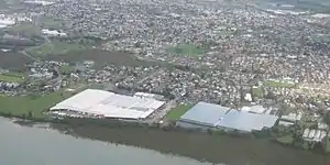 Favona from the air, looking south. | |
| |
| Country | New Zealand |
| Local authority | Auckland Council |
| Electoral ward | Manukau Ward |
| Local board | Māngere-Ōtāhuhu Local Board |
| Population (2018) | |
| • Total | 9,684 |
| Mangere Bridge | (Mangere Inlet / Manukau Harbour) | (Mangere Inlet / Manukau Harbour) |
| Mangere Bridge |
|
Ōtāhuhu, (Harania Creek) |
| Māngere | Māngere | Māngere East |
The area has a long history of habitation, due to its fertile lands, a productive harbour, and proximity to the Manukau-Tamaki isthmus. Māori of Ngāti Whātua were the inhabitants until they were supplanted by European farmers in the 19th century. The development of market gardening brought more people into the area and the land remained used in this way until the 1960s when housing developments were created to service Auckland's growing population and industry in nearby Onehunga and Otahuhu. Some areas of Favona also historically had large areas of greenhouses, such as for tomato production.[1]
The area is one is of relative poverty and until 2005 had one of New Zealand's largest Caravan parks. It hosts the Mangere campus of Te Wananga o Aotearoa. Numerous shipping and freight forwarding companies have premises in the industrial areas,[2] including the national distribution headquarters of supermarket chain Progressive Enterprises.
Demographics
| Year | Pop. | ±% p.a. |
|---|---|---|
| 2006 | 7,488 | — |
| 2013 | 8,514 | +1.85% |
| 2018 | 9,684 | +2.61% |
| Source: [3] | ||
Favona, comprising the statistical areas of Favona North, Favona West and Favona East, had a population of 9,684 at the 2018 New Zealand census, an increase of 1,170 people (13.7%) since the 2013 census, and an increase of 2,196 people (29.3%) since the 2006 census. There were 1,959 households. There were 4,866 males and 4,824 females, giving a sex ratio of 1.01 males per female, with 2,592 people (26.8%) aged under 15 years, 2,517 (26.0%) aged 15 to 29, 3,840 (39.7%) aged 30 to 64, and 735 (7.6%) aged 65 or older.
Ethnicities were 12.2% European/Pākehā, 14.2% Māori, 64.8% Pacific peoples, 21.3% Asian, and 1.3% other ethnicities (totals add to more than 100% since people could identify with multiple ethnicities).
The proportion of people born overseas was 43.5%, compared with 27.1% nationally.
Although some people objected to giving their religion, 15.1% had no religion, 64.6% were Christian, and 15.0% had other religions.
Of those at least 15 years old, 873 (12.3%) people had a bachelor or higher degree, and 1,572 (22.2%) people had no formal qualifications. The employment status of those at least 15 was that 3,507 (49.5%) people were employed full-time, 777 (11.0%) were part-time, and 507 (7.1%) were unemployed.[3]
Education
Favona School is a contributing primary school (years 1-6) with a roll of 376.[4]
Koru School is a full primary (years 1-6) with a roll of 555.[5]
Sir Keith Park School is a special school with a roll of 169.[6] It caters for students with intellectual disability or special needs.
All these schools are coeducational. Rolls are as of March 2020.[7]
References
- Taylor, Colin (14 February 2010). "Greenfields sale sparked by zone change". The New Zealand Herald. Retrieved 12 December 2010.
- Falconer, Phoebe (26 September 2006). "Get moving: Giving way to confusion". The New Zealand Herald. Retrieved 30 September 2011.
- "Statistical area 1 dataset for 2018 Census". Statistics New Zealand. March 2020. Favona North (148200), Favona West (148600) and Favona East (149400). 2018 Census place summary: Favona North 2018 Census place summary: Favona West 2018 Census place summary: Favona East
- Education Counts: Favona School
- Education Counts: Koru School
- Education Counts: Sir Keith Park School
- "New Zealand Schools Directory". New Zealand Ministry of Education. Retrieved 26 April 2020.
External links
- Photographs of Favona held in Auckland Libraries' heritage collections.
