Fort Hill, Pennsylvania
Fort Hill is an unincorporated community in Somerset County, Pennsylvania, United States.[1] The community is located along the Casselman River 4.6 miles (7.4 km) east-northeast of Confluence. Fort Hill has a post office with ZIP code 15540, which opened on December 23, 1885.[2][3]
Fort Hill, Pennsylvania | |
|---|---|
Unincorporated community | |
 Fort Hill | |
| Coordinates: 39°49′49″N 79°16′21″W | |
| Country | United States |
| State | Pennsylvania |
| County | Somerset |
| Elevation | 1,585 ft (483 m) |
| Time zone | UTC-5 (Eastern (EST)) |
| • Summer (DST) | UTC-4 (EDT) |
| ZIP code | 15540 |
| Area code(s) | 814 |
| GNIS feature ID | 1175007[1] |
Fort Hill was the location of a Monongahela Native American settlement, which a 1939-1940 WPA excavation directed by Edgar Augustine dated to around 1275-1300.[4]
Fort Hill sits along the old Baltimore and Ohio Railroad main line; a view of the natural landmark appeared in a collection of photographs from along the B&O's lines that was published in book form in 1872 and digitized by the DeGolyer Library, Southern Methodist University.[5]
Fort Hill has a trail access area for the Great Allegheny Passage rail trail. This is the only trail access area with parking between Markleton to the northeast and Harnedsville to the southwest.[6]
References
- "Fort Hill". Geographic Names Information System. United States Geological Survey.
- United States Postal Service. "USPS - Look Up a ZIP Code". Retrieved February 25, 2017.
- "Postmaster Finder - Post Offices by ZIP Code". United States Postal Service. Retrieved February 25, 2017.
- "Fort Hill". Pennsylvania Historical & Museum Commission. Retrieved May 5, 2020.
- Photographic Views of the Baltimore and Ohio Rail Road and Its Branches, From the Lakes to the Sea. First Series. Baltimore: Cushings & Bailey. 1872.
- "Interactive Map". Great Allegheny Passage. Retrieved May 16, 2020.
Municipalities and communities of Somerset County, Pennsylvania, United States | ||
|---|---|---|
| Boroughs | 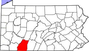 | |
| Townships | ||
| CDPs | ||
| Unincorporated communities | ||
| Footnotes | ‡This populated place also has portions in an adjacent county or counties | |
| ||