Rockwood, Pennsylvania
Rockwood is a borough in Somerset County, Pennsylvania, United States. The population was 890 at the 2010 census. It is part of the Johnstown, Pennsylvania, Metropolitan Statistical Area, and located due north of Pennsylvania's highest peak, Mount Davis, which significantly constricts land travel routing south of the municipality.
Rockwood, Pennsylvania
previously Mineral Point (c. 1857) | |
|---|---|
Borough | |
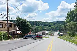 View down Bridge St. | |
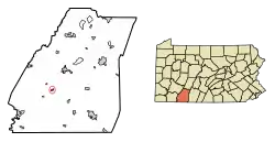 Location of Rockwood in Somerset County, Pennsylvania. | |
 Location of Rockwood in Somerset County, Pennsylvania. | |
| Coordinates: 39°54′58″N 79°09′21″W | |
| Country | United States |
| State | Pennsylvania |
| County | Somerset |
| Settled | 1857 |
| Incorporated | 1885 |
| Government | |
| • Type | Borough Council |
| Area | |
| • Total | 0.33 sq mi (0.87 km2) |
| • Land | 0.33 sq mi (0.87 km2) |
| • Water | 0.00 sq mi (0.00 km2) |
| Elevation | 1,837 ft (560 m) |
| Population (2010) | |
| • Total | 890 |
| • Estimate (2019)[2] | 820 |
| • Density | 2,455.09/sq mi (947.69/km2) |
| Time zone | UTC-5 (Eastern (EST)) |
| • Summer (DST) | UTC-4 (EDT) |
| Zip code | 15557 |
| Area code(s) | 814 |
| FIPS code | 42-65736 |
History

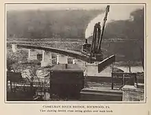
Rockwood was initially known as Shaff's Bridge and then Mineral Point.[3] Philip Wolfersberger built a house in what is now Rockwood in 1856, and he laid out the town in 1857 with Martin Meyers serving as the primary surveyor.[3] John Poister built a hotel in 1860.[3] 1868 saw the development of a post office, Henry Werner built a tannery in 1869, and a railroad depot was built in 1871.[3] Philip Stauffer Wolfersberger, a son of the above Philip Wolfersberger, was a ticket agent of the Baltimore & Ohio Railroad (B&O) and was instrumental in getting the current name of Rockwood to take hold.[3] A view of Mineral Point / Rockwood appeared in a collection of photographs from along the B&O's lines that was published in book form in 1872 and digitized by the DeGolyer Library, Southern Methodist University.[4]
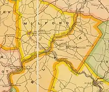
The Somerset & Mineral Point Railroad connected the town of Somerset with the Pittsburgh & Connellsville Railroad (owned by the B&O) as it passed through Mineral Point / Rockwood.[5] Both the Somerset & Mineral Point Railroad and the Pittsburgh & Connellsville Railroad were completed in 1871;[6] the final section of the line between Pittsburgh & Cumberland was completed on the afternoon of April 10, 1871,[7] with the final rail being laid near Forge Bridge, about 3 miles to the west of Mineral Point.[5][8] There were eight stations located along the Somerset & Mineral Point line as it ran northeast along Coxes Creek: Mineral Point, Sames, Baker's, Milford, Mud Pike Crossing, Roberts, Cantner, and Somerset.[9] Two individuals who were involved in the founding of Ursina, which had its own small branch railroad further south in Somerset County, were officers of the Somerset & Mineral Point Railroad in 1873: William J. Baer was President and H.L. Baer was Secretary.[10] The B&O bought the 10-mile Somerset & Mineral Point Railroad in 1879 for $60,000, knowing that an extension of the line to Johnstown, Pennsylvania, in Cambria County, was quite possible;[11] this extension had already received legislative approval with session law no. 321 on Aug. 12, 1873.[12] The Johnstown & Somerset Railroad followed the Stonycreek valley north-by-northeast from Somerset through Stoystown to Johnstown;[5] it was built in 1881.[6] The result was a rail line known as the Somerset & Cambria Branch Railroad stretching between the Pittsburgh & Connellsville Railroad at Rockwood and the Pennsylvania Railroad at Johnstown.[5] The Somerset & Cambria Branch later became known as the S&C Subdivision.
In 1891 the Somerset Stone Company built a branch line from the Somerset & Cambria Branch Railroad's station at Milford east to its operation at Bare Rocks.[13] A tragic accident along this company line on the evening of April 25, 1893, killed several people.[14] A collision between two trains on the Pittsburgh & Connellsville Railroad, occurring about three miles east of Rockwood, claimed six lives in November 1894.[15] The Wilson Creek Coal Company, in 1900, constructed a branch railroad off of the Somerset & Cambria Branch; this company line ran from about one mile north of Rockwood to its mining property about three miles to the east.[16]
The Baltimore & Ohio Railroad passes through Rockwood as it bends northerly in a long bow about the roots of Mount Davis, and it is now owned and operated by CSX, with daily Amtrak express trains between Pittsburgh and Cumberland, MD passing through the town and the nearby Cumberland Narrows. It is situated near and below the West slope-side summit-point of both the Nemacolin Trail and Braddock's Road, as well as the railway as each ascended past the crest up through the Cumberland Narrows pass from the forks of the Potomac at Harper's Ferry. The town was thus an important stop over point in the post-American Revolution westward migration into the Ohio Country and via the river boats built in Brownsville. The Penrose Wolf Building was added to the National Register of Historic Places in 2002.[17]
Geography
Rockwood is located at 39°54′58″N 79°9′21″W (39.916222, -79.155808).[18] It is situated near and below the west-side crest of the Eastern Continental Divide separating the Potomac-Mississippi riverine systems along the north bank of the Casselman River—whose head waters are to the south in nearby Western Maryland—and just west of its confluence with Coxes Creek.
According to the United States Census Bureau, the borough has a total area of 0.3 square miles (0.78 km2), all of it land.
Demographics
| Historical population | |||
|---|---|---|---|
| Census | Pop. | %± | |
| 1880 | 331 | — | |
| 1890 | 553 | 67.1% | |
| 1900 | 685 | 23.9% | |
| 1910 | 1,300 | 89.8% | |
| 1920 | 1,362 | 4.8% | |
| 1930 | 1,176 | −13.7% | |
| 1940 | 1,375 | 16.9% | |
| 1950 | 1,237 | −10.0% | |
| 1960 | 1,101 | −11.0% | |
| 1970 | 1,051 | −4.5% | |
| 1980 | 1,058 | 0.7% | |
| 1990 | 1,014 | −4.2% | |
| 2000 | 954 | −5.9% | |
| 2010 | 890 | −6.7% | |
| 2019 (est.) | 820 | [2] | −7.9% |
| Sources:[19][20][21] | |||
As of the census[20] of 2000, there were 954 people, 406 households, and 272 families residing in the borough. The population density was 3,053.4 people per square mile (1,188.2/km2). There were 421 housing units at an average density of 1,347.4 per square mile (524.4/km2). The racial makeup of the borough was 99.58% White, 0.10% Native American, 0.10% Asian, and 0.21% from two or more races.
There were 406 households, out of which 29.8% had children under the age of 18 living with them, 51.2% were married couples living together, 11.6% had a female householder with no husband present, and 33.0% were non-families. 29.1% of all households were made up of individuals, and 11.8% had someone living alone who was 65 years of age or older. The average household size was 2.28 and the average family size was 2.79.
In the borough the population was spread out, with 22.0% under the age of 18, 8.4% from 18 to 24, 27.7% from 25 to 44, 23.8% from 45 to 64, and 18.1% who were 65 years of age or older. The median age was 39 years. For every 100 females there were 92.3 males. For every 100 females age 18 and over, there were 92.7 males.
The median income for a household in the borough was $25,139, and the median income for a family was $31,023. Males had a median income of $26,500 versus $20,066 for females. The per capita income for the borough was $13,687. About 12.3% of families and 15.1% of the population were below the poverty line, including 13.7% of those under age 18 and 9.3% of those age 65 or over.
Schools
The borough of Rockwood is served by the Rockwood Area School District, which includes Rockwood Area Elementary School and Rockwood Area Junior/Senior High School. Both schools are located along the borough's boundary with Milford Township. A second elementary school within the district was the Kingwood Elementary School, which was not within the borough of Rockwood. Kingwood Elementary School is now closed, and the building was sold to the Kingwood Church of God.
Typically, Rockwood Area High School graduates 65-80 students per year.[22]
Transportation
Pennsylvania Route 653 runs through Rockwood. It comes southeast from New Centerville through part of Milford Township, entering Rockwood as Bridge Street. PA 653 then turns east onto Main Street, which it follows through the borough and out of town, entering Milford Township again briefly before crossing Coxes Creek and entering Black Township. The nearest limited-access highway is the Pennsylvania Turnpike at Somerset (Exit 110), 10 miles (16 km) to the north.
Up until April 30, 1971, Rockwood was a stop on the Baltimore & Ohio's daily Washington—Akron passenger train. Since 1981 Amtrak's Capitol Limited (Chicago—Washington) has passed through Rockwood without stopping. Since 1990 local officials have lobbied for Rockwood to be added as a stop, and in October 2009 Amtrak released a feasibility study which placed the cost of a new station at $2.2 million.[23][24] Proponents of the stop suggest that it might even benefit local resorts Seven Springs and Hidden Valley by increasing tourism business throughout the area.[25]
References
- "2019 U.S. Gazetteer Files". United States Census Bureau. Retrieved July 28, 2020.
- "Population and Housing Unit Estimates". United States Census Bureau. May 24, 2020. Retrieved May 27, 2020.
- History of Bedford, Somerset and Fulton Counties, Pennsylvania. Chicago: Waterman, Watkins & Co. 1884. p. 542.
- Photographic Views of the Baltimore and Ohio Rail Road and Its Branches, From the Lakes to the Sea. First Series. Baltimore: Cushings & Bailey. 1872.
- History of Bedford, Somerset and Fulton Counties, Pennsylvania. Chicago: Waterman, Watkins & Co. 1884. p. 180.
- Treese, Lorett (2004). Somerset Historical Center: Pennsylvania Trail of History Guide. Mechanicsburg, PA: Stackpole Books. p. 15.
- Baer, Christopher T. "A General Chronology of the Pennsylvania Railroad Company, Its Predecessors and Successors, and Its Historical Context: 1871" (PDF). Pennsylvania Railroad Technical & Historical Society. Retrieved January 23, 2021.
- "Pittsburgh Secures Direct Railroad Communication with Baltimore" (PDF). Chicago Tribune. April 11, 1871. Retrieved October 16, 2020.
- Platt & Platt, Franklin & W.G. (1877). Report of Progress in the Cambria and Somerset District of the Bituminous Coal-Fields of Western Pennsylvania. Part II: Somerset. Harrisburg, PA: Board of Commissioners, Second Geological Survey of Pennsylvania. p. xvi.
- Poor, Henry V. (1873). Manual of the Railroads of the United States for 1873-74. New York: H.V. & H.W. Poor. p. 506.
- "Baltimore & Ohio". Commercial & Financial Chronicle, Vol. 29, No. 741. September 6, 1879. Retrieved May 17, 2020.
- Constitution of the Commonwealth of Pennsylvania: Also Laws of the General Assembly of Said Commonwealth Passed at the Session of 1874, in the Ninety-Eighth Year of Independence. Harrisburg, PA: Benjamin Singerly. 1874. pp. 432–433.
- "Thinks the Boom Is Booming" (PDF). Somerset Herald. June 10, 1891. Retrieved October 18, 2020.
- "Frightful Accident" (PDF). Somerset Herald. April 26, 1893. Retrieved October 18, 2020.
- "A Terrible Collision" (PDF). Somerset Herald. November 14, 1894. Retrieved October 17, 2020.
- "A Charter Was Granted" (PDF). Somerset Herald. May 30, 1900. Retrieved October 17, 2020.
- "National Register Information System". National Register of Historic Places. National Park Service. July 9, 2010.
- "US Gazetteer files: 2010, 2000, and 1990". United States Census Bureau. 2011-02-12. Retrieved 2011-04-23.
- "Census of Population and Housing". U.S. Census Bureau. Retrieved 11 December 2013.
- "U.S. Census website". United States Census Bureau. Retrieved 2008-01-31.
- "Incorporated Places and Minor Civil Divisions Datasets: Subcounty Resident Population Estimates: April 1, 2010 to July 1, 2012". Population Estimates. U.S. Census Bureau. Archived from the original on 11 June 2013. Retrieved 11 December 2013.
- Public Schools Report http://schools.publicschoolsreport.com/Pennsylvania/Rockwood/RockwoodAreaJshs.html%5B%5D
- Rock, Vicki (June 24, 2008). "Chamber lobbies for Rockwood Amtrak stop". Daily American. Retrieved 2009-12-18.
- Amtrak (October 16, 2009). "P.R.I.I.A. Section 224: Pennsylvania Feasibility: Studies Report" (PDF). Retrieved 2009-12-18.
- O’Reilly, Russ (Aug 15, 2010). "Rockwood Amtrak Stop Studied". The Tribune-Democrat. Retrieved June 6, 2020.
Municipalities and communities of Somerset County, Pennsylvania, United States | ||
|---|---|---|
| Boroughs | 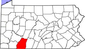 | |
| Townships | ||
| CDPs | ||
| Unincorporated communities | ||
| Footnotes | ‡This populated place also has portions in an adjacent county or counties | |
| ||