Milford Township, Somerset County, Pennsylvania
Milford Township is a township in Somerset County, Pennsylvania, United States. The population was 1,561 at the 2000 census. It is part of the Johnstown, Pennsylvania, Metropolitan Statistical Area.
Milford Township, Somerset County, Pennsylvania | |
|---|---|
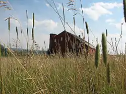 A farm in Milford Township | |
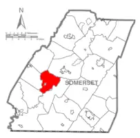 Map of Somerset County, Pennsylvania Highlighting Milford Township | |
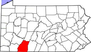 Map of Somerset County, Pennsylvania | |
| Country | United States |
| State | Pennsylvania |
| County | Somerset |
| Area | |
| • Total | 29.75 sq mi (77.06 km2) |
| • Land | 29.75 sq mi (77.05 km2) |
| • Water | 0.01 sq mi (0.01 km2) |
| Population (2010) | |
| • Total | 1,553 |
| • Estimate (2016)[2] | 1,516 |
| • Density | 50.96/sq mi (19.68/km2) |
| Time zone | UTC-5 (Eastern (EST)) |
| • Summer (DST) | UTC-4 (EDT) |
| FIPS code | 42-111-49416 |
Geography
According to the United States Census Bureau, Milford Township has a total area of 29.2 square miles (75.8 km2), of which 29.2 square miles (75.8 km2) is land and 0.03% is water. The township surrounds the borough of New Centerville. Milford Township is bordered by Jefferson Township to the northwest, Somerset Township to the northeast, Black Township to the southeast, Upper Turkeyfoot Township to the southwest, and Middlecreek Township to the west.
Pennsylvania Route 281 passes through Milford Township, generally running northeast from New Lexington in Middlecreek Township, passing through New Centerville and bisecting Milford Township, and continuing through the southwestern part of Somerset Township on its way to the borough of Somerset. From New Lexington to New Centerville, Pennsylvania Route 281 & Pennsylvania Route 653 form a concurrency; in New Centerville, Pennsylvania Route 653 splits off and runs southeast to the borough of Rockwood. Rockwood sits at the confluence of Coxes Creek and the Casselman River, between Milford Township to the northwest and Black Township to the southeast. Black Township had been part of Milford Township until it was split off in 1886.[3]
Demographics
| Historical population | |||
|---|---|---|---|
| Census | Pop. | %± | |
| 2010 | 1,553 | — | |
| 2016 (est.) | 1,516 | [2] | −2.4% |
| U.S. Decennial Census[4] | |||
At the 2000 census there were 1,561 people, 602 households, and 473 families living in the township. The population density was 53.4 people per square mile (20.6/km2). There were 658 housing units at an average density of 22.5/sq mi (8.7/km2). The racial makeup of the township was 99.81% White, 0.06% African American, 0.06% Asian, and 0.06% from two or more races. Hispanic or Latino of any race were 0.19%.[5]
Of the 602 households 30.2% had children under the age of 18 living with them, 69.6% were married couples living together, 5.1% had a female householder with no husband present, and 21.4% were non-families. 18.6% of households were one person and 8.8% were one person aged 65 or older. The average household size was 2.58 and the average family size was 2.93.
The age distribution was 22.4% under the age of 18, 6.3% from 18 to 24, 28.6% from 25 to 44, 26.8% from 45 to 64, and 15.8% 65 or older. The median age was 41 years. For every 100 females, there were 98.9 males. For every 100 females age 18 and over, there were 99.8 males.
The median household income was $34,458 and the median family income was $38,750. Males had a median income of $29,038 versus $21,000 for females. The per capita income for the township was $14,836. About 11.4% of families and 14.3% of the population were below the poverty line, including 17.5% of those under age 18 and 25.0% of those age 65 or over.
References
- "2016 U.S. Gazetteer Files". United States Census Bureau. Retrieved Aug 14, 2017.
- "Population and Housing Unit Estimates". Retrieved June 9, 2017.
- "Black Township". PAGenWeb Project. Retrieved May 26, 2020.
- "Census of Population and Housing". Census.gov. Retrieved June 4, 2016.
- "U.S. Census website". United States Census Bureau. Retrieved 2008-01-31.
Municipalities and communities of Somerset County, Pennsylvania, United States | ||
|---|---|---|
| Boroughs | | |
| Townships | ||
| CDPs | ||
| Unincorporated communities | ||
| Footnotes | ‡This populated place also has portions in an adjacent county or counties | |
| ||