Fulton County Airport (Georgia)
Fulton County Airport (IATA: FTY, ICAO: KFTY, FAA LID: FTY), also known as Charlie Brown Field or Brown’s Field, is a county-owned, public-use airport in Fulton County, Georgia, United States. It is located six nautical miles (7 mi, 11 km) west of the central business district of Atlanta.[1] The airport's name comes from the nickname of former Atlanta politician Charles M. Brown, who served on the city council and county commission during the 1960s. It is also called Charlie Brown Airport or Brown Field. On the radio, however, it is referred to as "County Tower" or "County Ground".
Fulton County Airport Charlie Brown Field | |||||||||||||||||||
|---|---|---|---|---|---|---|---|---|---|---|---|---|---|---|---|---|---|---|---|
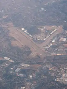 Aerial view, January 2010 | |||||||||||||||||||
| Summary | |||||||||||||||||||
| Airport type | Public | ||||||||||||||||||
| Owner | Fulton County | ||||||||||||||||||
| Serves | Atlanta, Georgia | ||||||||||||||||||
| Elevation AMSL | 841 ft / 256 m | ||||||||||||||||||
| Coordinates | 33°46′45″N 084°31′17″W | ||||||||||||||||||
| Map | |||||||||||||||||||
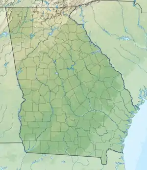 FTY Location of airport in Georgia / United States  FTY FTY (the United States) | |||||||||||||||||||
| Runways | |||||||||||||||||||
| |||||||||||||||||||
| Statistics | |||||||||||||||||||
| |||||||||||||||||||
As per Federal Aviation Administration records, the airport had 293 passenger boardings (enplanements) in calendar year 2008,[2] 198 enplanements in 2009, and 725 in 2010.[3] It is included in the National Plan of Integrated Airport Systems for 2011–2015, which categorized it as a reliever airport.[4]
It is a local Class D airport located just west of Atlanta and the nearest airport to Hartsfield-Jackson Atlanta International Airport (which is just south of Atlanta), and handles much of the general aviation traffic that would otherwise go there. The airport exists below and in close proximity to ATL's Class B airspace.
It is located very near Interstate 20, Interstate 285, and the Chattahoochee River, just outside the Atlanta city limits. It reports ASOS weather conditions 24 hours per day as West Atlanta. It also acted as the nearest backup weather station when Dobbins Air Reserve Base did not report overnight.
Facilities and aircraft
Fulton County Airport covers an area of 985 acres (399 ha) at an elevation of 841 feet (256 m) above mean sea level. It has three asphalt paved runways: 8/26 is 5,796 by 100 feet; 14/32 is 4,157 by 100 feet (1,267 x 30 m); 9/27 is 2,801 by 60 feet (854 x 18 m).[1] It is currently under the management of the Fulton County Public Works Department. David E. Clark is the Fulton County Public Works Director and Tim Beggerly is the Airport Manager.
In 2015, the airport had exactly 60,000 general aviation aircraft operations, an average of 164 per day; a 52% decrease from 2008. In May 2017, there were 82 aircraft based at this airport: 30 single-engine, 12 multi-engine, 35 jet, and 5 helicopter.[1]
References
- FAA Airport Form 5010 for FTY PDF. Federal Aviation Administration. effective May 25, 2017.
-
"Enplanements for CY 2008" (PDF, 1.0 MB). CY 2008 Passenger Boarding and All-Cargo Data. Federal Aviation Administration. December 18, 2009. External link in
|work=(help) -
"Enplanements for CY 2010" (PDF, 189 KB). CY 2010 Passenger Boarding and All-Cargo Data. Federal Aviation Administration. October 4, 2011. External link in
|work=(help) -
"2011–2015 NPIAS Report, Appendix A" (PDF). National Plan of Integrated Airport Systems. Federal Aviation Administration. October 4, 2010. Archived from the original (PDF, 2.03 MB) on 2012-09-27. External link in
|work=(help)
External links
- FTY - Fulton County Airport-Brown Field at Georgia DOT website
- Aerial image as of April 2002 from USGS The National Map
- FAA Airport Diagram (PDF), effective January 28, 2021
- FAA Terminal Procedures for FTY, effective January 28, 2021
- Resources for this airport:
- FAA airport information for FTY
- AirNav airport information for KFTY
- ASN accident history for FTY
- FlightAware airport information and live flight tracker
- NOAA/NWS weather observations: current, past three days
- SkyVector aeronautical chart, Terminal Procedures