Gafsa Governorate
Gafsa Governorate (Tunisian Arabic: ولاية ڨفصة Wilāyat Gafṣa) is one of the 24 governorates of Tunisia. It is situated in central Tunisia, bordering Algeria. It covers an area of 7807 km²[1] and has a population of 337,331 (2014 census).[3][4] The capital of the city is Gafsa - ruled by Malek Necibi[2] - whom all the heads of local municipalities report to.
Gafsa
ڨفصة | |
|---|---|
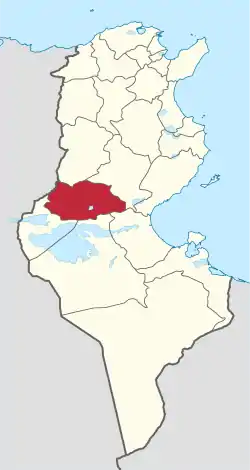 Map of Tunisia with Gafsa highlighted | |
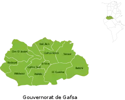 Subdivisions of Gafsa Governorate | |
| Coordinates: 34°25′N 8°47′E | |
| Country | Tunisia |
| Created | June 21, 1956[1] |
| Capital | Gafsa |
| Government | |
| • Governor | Malek Necibi (2012)[2] |
| Area | |
| • Total | 7,807 km2 (3,014 sq mi) |
| Area rank | Ranked 5th of 24 |
| Population (2014) | |
| • Total | 337,331 |
| • Rank | Ranked 17th of 24 |
| • Density | 43/km2 (110/sq mi) |
| Time zone | UTC+01 (CET) |
| Postal prefix | xx |
| ISO 3166 code | TN-71 |
Geography
The governorate is located 355 kilometres (221 mi) from the capital and borders the governorates of Gabès, Sidi Bouzid, Kebili, Tozeur, and Kasserine.
The average temperature is 19.8 °C and annual rainfall is 48.9 millimeters.[1]
Administrative divisions
Administratively, the governorate is divided into eleven delegations (mutamadiyat), eight municipalities, nine rural councils, and 76 sectors (imadas).[1] The delegations and their populations from the 2004 and 2014 censuses,[3] are listed below:
| Delegation | Population in 2004 | Population in 2014 |
|---|---|---|
| Belkhir | 15,159 | 14,784 |
| El Guetar | 19,942 | 20,137 |
| El Ksar | 32,186 | 36,482 |
| Gafsa Nord | 9,407 | 10,022 |
| Gafsa Sud | 90,742 | 10,148 |
| Mdhilla | 14,841 | 15,306 |
| Metlaoui | 38,938 | 38,634 |
| Oum El Araies | 31,733 | 27,012 |
| Redeyef | 27,940 | 26,976 |
| Sidi Aïch | 8,297 | 10,084 |
| Sned | 34,524 | 36,746 |
The following eight municipalities are located in Gafsa Governorate:
| Code | Municipality | Population (2014)[5] |
|---|---|---|
| 6111 | Gafsa | 95,242 |
| 6112 | El Ksar | 33,729 |
| 6113 | Moularès | 21,431 |
| 6114 | Redeyef | 25,046 |
| 6115 | Métlaoui | 38,129 |
| 6116 | Mdhila | 12,814 |
| 6117 | El Guettar | 14,088 |
| 6118 | Sened | 9,533 |
References
- (in French) "tunisieindustrie.nat.tn". Archived from the original on 2014-12-19.
- http://www.ins.tn/ar/%D8%A7%D9%84%D8%A7%D8%AA%D8%B5%D8%A7%D9%84
- "2014 Tunisian census data". Archived from the original on 2015-05-18.
- (in French) Census 2014 (National Institute of Statistics) Archived 2014-10-29 at the Wayback Machine
- Recensement Général de la Population et de l'Habitat 2014 – Population, logements et ménages par commune et arrondissement [Census 2014 results – population, accommodation and households per municipality and delegation] (Report) (in French). National Institute of Statistics. 1 April 2015. Retrieved 18 February 2016.
Governorates and regions of Tunisia | ||
|---|---|---|
| Governorates | ||
| Regions | ||
WikiProject Tunisia | ||