Kairouan Governorate
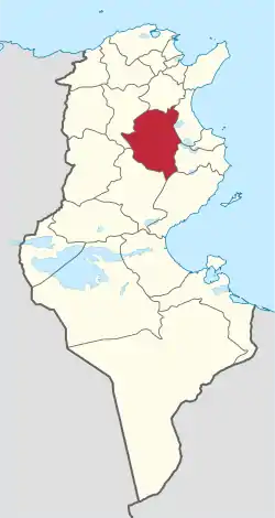
Kairouan Governorate (Tunisian Arabic: ولاية قيروان Wilāyat Qiyrwān) is one of the twenty-four governorates of Tunisia. It is landlocked and in the centre-east of the country. It covers an area of 6,712 km² and has a population of 570,559 (2014 census). The narrower province of Sousse borders it to the east, the nearest coastline[1] The capital is Kairouan. Lowland parts of the province are semi-arid, experiencing in most years light rains in the winter months and scant rainfall in other months but higher parts attract relief precipitation in and around the Djebel Zhagdoud and a large part of the Djebel Serj national parks, in the north-east of the province which are geologically outcrops of the Dorsal Atlas mountains in the province to the north.
Kairouan
قيروان | |
|---|---|
 Map of Tunisia with Kairouan highlighted | |
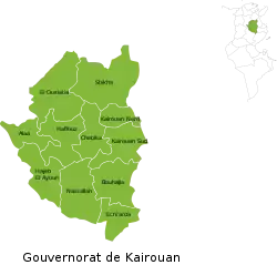
 Subdivisions of Kairouan Governorate | |
| Coordinates: 35°40′N 10°06′E | |
| Country | Tunisia |
| Created | 21 June 1956 |
| Capital | Kairouan |
| Area | |
| • Total | 6,712 km2 (2,592 sq mi) |
| Area rank | Ranked 9th of 24 |
| Population (2014) | |
| • Total | 570,559 |
| • Rank | Ranked 5th of 24 |
| • Density | 85/km2 (220/sq mi) |
| Time zone | UTC+01 (CET) |
| Postal prefix | xx |
| ISO 3166 code | TN-41 |
Administrative divisions
The Kairouan Governorate is divided into eleven delegations (mutamadiyat), listed below with their populations at the 2004 and 2014 Censuses,[2] and further sub-divided into sectors (imada).
| Delegation | Area in km2 | Population 2004 Census | Population 2014 Census |
|---|---|---|---|
| Alaâ | 361 | 31,773 | 28,991 |
| Bou Hajla | 690 | 70,589 | 72,371 |
| Chebika | 513 | 33,889 | 35,308 |
| Echrarda | 330 | 25,903 | 27,518 |
| Haffouz | 611 | 43,792 | 40,066 |
| Hajeb El Ayoun | 589 | 35,403 | 36,137 |
| Kairouan Nord | 251 | 83,794 | 96,781 |
| Kairouan Sud | 520 | 80,444 | 93,101 |
| Nasrallah | 685 | 37,112 | 33,789 |
| Oueslatia | 915 | 36,195 | 34,452 |
| Sbikha | 1,069 | 67,315 | 71,922 |
Twelve municipalities are included within Kairouan Governorate:
| Code | Municipality | Population (2014)[3] |
|---|---|---|
| 4111 | Kairouan | 139,070 |
| 4112 | Chebika | 2,921 |
| 4113 | Sbikha | 8,036 |
| 4114 | Oueslatia | 9,006 |
| 4115 | Aïn Djeloula | 1,757 |
| 4116 | Haffouz | 8,429 |
| 4117 | Alaâ | 3,276 |
| 4118 | Hajeb El Ayoun | 10,621 |
| 4119 | Nasrallah | 5,012 |
| 4120 | Menzel Mehiri | 3,870 |
| 4121 | Echrarda | 1,705 |
| 4122 | Bou Hajla | 7,828 |
Nature reserves
References
- (in French)Census 2014 (National Institute of Statistics) Archived 2014-10-29 at the Wayback Machine
- Institut National de la Statistique Tunisie (web).
- Recensement Général de la Population et de l'Habitat 2014 – Population, logements et ménages par commune et arrondissement [Census 2014 results – population, accommodation and households per municipality and delegation] (Report) (in French). National Institute of Statistics. 1 April 2015. Retrieved 18 February 2016.
- "Reserve Naturelle" (PDF). www.onagri.nat.tn. Retrieved 23 April 2018.