Siliana Governorate
Siliana Governorate (Tunisian Arabic: ولاية سليانة Wilāyat Silyānah pronounced [ˌsɪlˈjæːnæ]) is one of the twenty-four governorates (provinces) of Tunisia, is landlocked and is in the north of the country. It covers an area of 4,631 km² and has a population of 223,087 (2014 census).[1] The capital is Siliana.
Siliana
ولاية سليانة | |
|---|---|
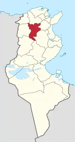 Map of Tunisia with Siliana highlighted | |
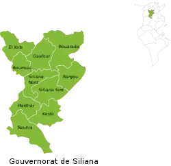 Subdivisions of Siliana Governorate | |
| Coordinates: 36°10′N 9°22′E | |
| Country | Tunisia |
| Created | June 5, 1974 |
| Capital | Siliana |
| Area | |
| • Total | 4,642 km2 (1,792 sq mi) |
| Area rank | Ranked 12th of 24 |
| Population (2014) | |
| • Total | 223,087 |
| • Rank | Ranked 20th of 24 |
| • Density | 48/km2 (120/sq mi) |
| Time zone | UTC+01 (CET) |
| Postal prefix | xx |
| ISO 3166 code | TN-34 |
Geography
The province is coextensive with the upper Oued Siliana (Siliana river) catchment which flows north. The land includes a largely fertile valley, tributary valleys, and rocky and forested uplands. It generally slopes north. The south of the governorate tapers in a curve to include the three main peaks at the head of the valley in the dorsal Atlas Mountains. Shortly after leaving the governorate, the Oued Siliana feeds into the valley of the Medjerda River, which flows east. Two main settlements are beside the river: Siliana and Gaafour (Qa Afur). Two forested ridges form national parks mainly within and outside the north-west and south-east borders respectively. The higher of these is the Djebel Serj to the south east. The Siliana Barrage, below the city, is an artificial reservoir and is the largest lake in the province, followed by the Lakhmess Barrage in the south-east, which is less than a third of its size. The climate is more Mediterranean than desert, as it is near the coast (see Tunisia§Climate) with temperatures in all but the northern borders moderated by its high elevation.[2]
Administrative divisions
Ten municipalities are in Siliana Governorate:
| Code | Municipality | Population (2014)[3] |
|---|---|---|
| 2411 | Siliana | 31,251 |
| 2412 | Bou Arada | 13,162 |
| 2413 | Gaâfour | 10,399 |
| 2414 | El Krib | 7,841 |
| 2415 | Sidi Bou Rouis | 3,258 |
| 2416 | Maktar | 13,542 |
| 2417 | Rouhia | 4,675 |
| 2418 | Kesra | 2,602 |
| 2419 | Bargou | 4,916 |
| 2420 | El Aroussa | 2,905 |
References
- (in French) Census 2014 (National Institute of Statistics) Archived 2014-10-29 at the Wayback Machine
- Physical Map of Tunisia
- Recensement Général de la Population et de l'Habitat 2014 – Population, logements et ménages par commune et arrondissement [Census 2014 results – population, accommodation and households per municipality and delegation] (Report) (in French). National Institute of Statistics. 1 April 2015. Retrieved 18 February 2016.
Governorates and regions of Tunisia | ||
|---|---|---|
| Governorates | ||
| Regions | ||
WikiProject Tunisia | ||