Galt, Kansas
Galt is a ghost town in central Galt Township, Rice County, Kansas, United States. It lies along the Little Arkansas River, 6 miles (9.7 km) southeast of Geneseo and 14 miles (23 km) northeast of Lyons.[2][3]
Galt, Kansas | |
|---|---|
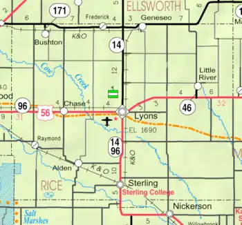 KDOT map of Rice County (legend) | |
 Galt  Galt | |
| Coordinates: 38°27′52″N 98°5′4″W | |
| Country | United States |
| State | Kansas |
| County | Rice |
| Township | Galt |
| Elevation | 1,650 ft (500 m) |
| Time zone | UTC-6 (CST) |
| • Summer (DST) | UTC-5 (CDT) |
| Area code | 620 |
| GNIS ID | 484742[1] |
History
For millennia, the land now known as Kansas was inhabited by Native Americans. In 1803, most of modern Kansas was secured by the United States as part of the Louisiana Purchase. In 1854, the Kansas Territory was organized, then in 1861 Kansas became the 34th U.S. state. In 1867, Rice County was founded.
Circa 1910, Galt contained a general store and 15 inhabitants. It was a shipping point on the Atchison, Topeka, and Santa Fe railroad.[4]
The post office in Galt closed in 1911.[5]
References
- "US Board on Geographic Names". United States Geological Survey. 2007-10-25. Retrieved 2008-01-31.
- DeLorme. Kansas Atlas & Gazetteer. 4th ed. Yarmouth: DeLorme, 2009, p. 47. ISBN 0-89933-342-7.
- "Find a County". National Association of Counties. Archived from the original on 2011-05-31. Retrieved 2011-06-07.
- Blackmar, Frank Wilson (1912). Kansas: A Cyclopedia of State History, Embracing Events, Institutions, Industries, Counties, Cities, Towns, Prominent Persons, Etc. Standard Publishing Company. pp. 706.
- "Kansas Post Offices, 1828-1961". Kansas Historical Society. Archived from the original on October 9, 2013. Retrieved 22 June 2014.
Further reading
Municipalities and communities of Rice County, Kansas, United States | ||
|---|---|---|
| Cities | 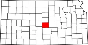 Map of Kansas highlighting Rice County | |
| Unincorporated communities | ||
| Ghost towns | ||
| Townships | ||
| ||
This article is issued from Wikipedia. The text is licensed under Creative Commons - Attribution - Sharealike. Additional terms may apply for the media files.