Gatineau River
The Gatineau River (French: Rivière Gatineau, French pronunciation: [gatino]) is a river in western Quebec, Canada, which rises in lakes north of the Baskatong Reservoir and flows south to join the Ottawa River at the city of Gatineau, Quebec. The river is 386 km (239.8 mi) long and drains an area of 23,700 km².
| Gatineau River Rivière Gatineau | |
|---|---|
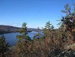 The upper Gatineau River | |
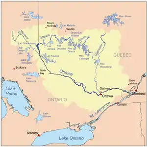 Map of the Ottawa River drainage basin with the Gatineau River | |
| Location | |
| Country | Canada |
| Province | Quebec |
| Region | Outaouais |
| Physical characteristics | |
| Source | Unnamed wilderness |
| • location | near boundary between Outaouais and Mauricie regions |
| Mouth | Ottawa River |
• location | City of Gatineau |
• coordinates | 45°27′15″N 75°41′42″W |
| Length | 386 km (240 mi)[1] |
| Basin size | 23,724 km2 (9,160 sq mi)[1] |
| Discharge | |
| • location | Paugan Power Station[1] |
| • average | 350 m3/s (12,000 cu ft/s)[1] |
| Basin features | |
| Progression | Ottawa River→ Saint Lawrence River→ Gulf of Saint Lawrence |
| River system | Ottawa River drainage basin |
While it has been said that the river's name comes from Nicolas Gatineau (sometimes spelled Gastineau), a fur trader who is said to have drowned in the river in 1683, the original inhabitants, the Algonquin Anicinabek, assert that the name comes from their language. The name they give the river is "Te-nagàdino-zìbi", which means "The River that Stops [One's Journey]".
Geography
_vers_l'amont-2018-10-07.jpg.webp)
The geography of the area was altered with the construction of the Baskatong Reservoir, and it is still possible to travel upstream on the Gatineau and reach a point where a small portage will bring you to the headwaters of the Ottawa River. The Ottawa River then flows northwest and turns south where it eventually flows more easterly and connects with the Gatineau.
The river flows through the communities of:
A covered wooden bridge over the river at Wakefield, built in 1915, was destroyed by arson in 1984, but has been rebuilt.
History
Exploration and naming
This river was an important transportation corridor for native people of the region and early explorers. On June 4, 1613, Samuel de Champlain passed here while travelling on the Ottawa River to L'Isle-aux-Allumettes. He wrote:
We passed near a river coming from the north, where a people called "Algoumequins" can be found, which drains into the great St-Lawrence River, three leagues downstream from the Saint-Louis Falls, makes an island of nearly forty leagues, and which is not large but filled with an indefinite number of falls which are very difficult to pass. Sometimes, these people use this river to avoid meeting their enemies, knowing that they will not seek them in such difficult accessible places.
He noted this "river coming from the north" but did not give its name.
According to the Bulletin des recherches historiques (1895), the land-surveyor Noël Beaupré wrote an official report on the river on February 3, 1721, but without naming it, leaving it unclear if its current name was in use in the 18th century.
In 1783, in a report to the governor Frederick Haldimand, lieutenant David Jones called the river by the name "River Lettinoe". According to Lucien Brault (History of Pointe-Gatineau, 1948), this would be the first written reference to the name Gatineau. On the charts of his account from 1830, but recalling events from the beginning of the 19th century, the traveller and fur trader Jean-Baptiste Perrault called the river "nàgàtinong" or "àgatinung".
On a plan of the Rideau Canal, drawn by lieutenant-colonel John By in 1831, the river is called "Gatteno". Finally, "R. Gatineau" appears on the chart of William Henderson in 1831, and on the one of Thomas Guesses, in 1861.
This name recollects the memory of a fur trader from the 17th century, Nicolas Gatineau or Gastineau. Inhabitant of Trois-Rivières, he had traded near a river located between the Ottawa and Saint-Maurice Rivers, which was then customarily called river of Gatineau. But according to Raymond Douville, at the end of the 17th century Louis (1674-1750) and Jean-Baptiste (1671-1750), sons of Nicolas, established a trading post, or just a supply post, on a point located at the mouth of the river, site of the future Point-Gatineau. Therefore, the toponym given to the river is more likely a credit to the Gatineau sons than to Nicolas.[2]
Economic uses
From the 19th century until 1991, the river was used to transport logs to sawmills near the mouth of the river. Philemon Wright and his descendants played an important role in the development of the lumber industry in the Gatineau valley. In more recent times, with declining quality in the forests of the region, logs were used for pulp and paper.
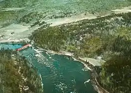
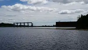
The river has been extensively dammed and is an important source of hydroelectric power. In 1925, three hydroelectric dams were constructed along the lower Gatineau River, making them one of the biggest economic and industrial projects in the region's history. These are now known today as the Paugan, Chelsea and Rapides-Farmers Hydroelectric Stations (Centrale Paugan, Centrale Chelsea and Centrale Rapides-Farmers). The stations are located within the municipalities of Low, Cantley and Gatineau.[3]
The Hull-Chelsea-Wakefield Railway, a tourist steam train, followed a route up the Gatineau valley to Wakefield.
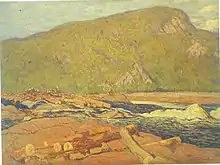
In 1915, Canadian artist and member of the Group of Seven J. E. H. MacDonald would depicted logging operations on the river is his painting, Logs on the Gatineau.[4]
Flooding
In the spring of 1974, there was extensive flooding along the Gatineau.
_%C3%A0_partir_de_la_rive_gauche-2018-10-07.jpg.webp)
Tributaries
Major tributaries of the Gatineau River in upstream order are:[5]
- La Pêche River
- Kazabazua River
- Picanoc River
- Grand Lac Rond
- Thirty-one Mile Lake
- Rivière Désert
- Rivière de l'Aigle (Eagle River)
- Tomasine River
- Désert Lake
- Ignace River
- Baskatong Reservoir
- Gens de Terre River
- Wapus River
- Belinge River
- Cabonga Reservoir
- Rivière d'Argent
- Notawassi River
- Petawaga River
- Petawaga Lake
- Gens de Terre River
- Bazin River
- Rivière aux Bleuets
- Rivière à la Marte (Marten River)
- Dandurand River
- Rivière du Canot (Canoe River)
- Choquette River
- Chabot River
- Fortier River
- Chouart River
- Tamarac River
- Clova River
References
- Ottawa Gatineau Watershed Atlas - Gatineau River Watershed Profile Archived 2010-06-05 at the Wayback Machine
- Commission de toponymie du Québec
- "Chelsea and Farmers Hydroelectric Dams". Retrieved February 21, 2016.
- Silcox, David P. (2011). The Group of Seven and Tom Thomson. Richmond Hill: Firefly Books. pp. 211, 256. ISBN 978-1554078851.
- Atlas of Canada
External links
| Wikimedia Commons has media related to Gatineau River. |
- Ottawa-Gatineau Watershed Atlas
- Gatineau River
- Festival d'eau vive de la Haute-Gatineau - A festival dedicated to the preservation of rivers.
| Authority control |
|
|---|