Gejiu
![]() Gejiu (simplified Chinese: 个旧; traditional Chinese: 箇舊; pinyin: Gèjiù; Hani: Goqjef; Wade-Giles: Ko-chiu; formerly known as Kochiu) is a county-level city and the former capital of Honghe prefecture, Yunnan Province, China, and has 202,000[note 1] urban inhabitants (ranked 14th largest city in Yunnan).[1] It is the site of the country's largest tin deposits and its main industry is mining.
Gejiu (simplified Chinese: 个旧; traditional Chinese: 箇舊; pinyin: Gèjiù; Hani: Goqjef; Wade-Giles: Ko-chiu; formerly known as Kochiu) is a county-level city and the former capital of Honghe prefecture, Yunnan Province, China, and has 202,000[note 1] urban inhabitants (ranked 14th largest city in Yunnan).[1] It is the site of the country's largest tin deposits and its main industry is mining.
Gejiu
个旧市 | |
|---|---|
 Gejiu from the southeast | |
 Gejiu Location within China | |
| Coordinates: 23°22′N 103°09′E | |
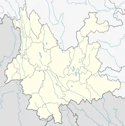
| Country | People's Republic of China |
| Province | Yunnan |
| Prefecture | Honghe |
| Area | |
| • Total | 1,587 km2 (613 sq mi) |
| Population | |
| • Total | 390,000 |
| • Density | 250/km2 (640/sq mi) |
| Postal code | 661000 |
| Area code(s) | 0873 |
| Website | www |
Location

Gejiu is located on top of a mountain to the north of the Red River (pinyin Hong He) valley, which flows from Yunnan, Dali prefecture to Vietnam. To the south-west in this valley is Nansha, which lies directly below the town of Yuanyang. To the north-west lies Jianshui, and to the north Jijie. Mengzi lies 12 miles to the East.
Layout
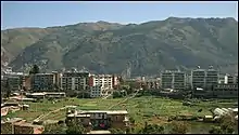
The town is located in a crater-like depression around a lake on top of a mountain. The main road enters the town from the north through a thin pass. To the east and west are steep cliffs. Those to the west are too steep to inhabit, however extensive new construction along the eastern side has created many new districts.
Administrative divisions
Administratively, the County-level City of Gejiu consists of 10 township level units:
- 1 subdistrict :Chengqu (城区街道), which includes the city proper
- 7 towns: Xicheng (錫城镇),Shadian (沙甸镇), Jijie (雞街镇), Datun (大屯镇), Laochang (老廠镇), Kafang (卡房镇),and Manhao (蔓耗镇)
- 2 townships: Jiasha (贾沙乡),and Baohe (保和乡)
History

Originally a small mining settlement Gejiu was called Gejiuli. Under the Yuan (1206–1368) and Ming (1368–1644) dynasties the mining of silver was begun there.
In the late 17th and 18th centuries, mining in Yunnan boomed, but tin mining in Gejiu did not develop until the second half of the 18th century.
In the 1880s the city was created a subprefecture under Mengzi County, about 30 km (19 mi) to the east.
Gejiu only began to be developed after the French connected the area to the railway down off the Yunnan plateau into Vietnam. After the 1911 Revolution it was further developed due to its location up in the mountains, surrounded by abundant tin reserves.
In 1889 Mengzi was opened as a treaty port, its trade being almost entirely with Hanoi and Haiphong in what was then French Indochina. One of the main purposes in constructing the French-built Kunming–Hai Phong Railway, completed in 1910, was to service the mines. A branch line was built from Gejiu to Mengzi between 1915 and 1928. During the last years of the Qing dynasty (1644–1911/12), the mines were organized by the Chinese-owned Gejiu Tin Company, but the company was deficient in capital, technical skill, and managerial efficiency and was replaced by a joint state-private company, the Gejiu Tin-Mining Company, under which production boomed. By the 1930s Gejiu tin accounted for 80 percent of the traffic exported on the railway. Tin production is said to have reached 10,000 tons in 1938.
After 1949 management passed to the state Yunnan Tin-Mining Corporation, which by 1955 had reached and surpassed prewar production figures. In addition to mining tin, which remains the chief product, Gejiu has also become a major producer of lead, and a thriving metallurgical industry has been developed. Tin articles made in Gejiu are highly acclaimed in China. Coal for smelting is supplied to the city from nearby Kaiyuan to the north, located on the rail line to Kunming. There is some engineering and chemical production closely allied with Gejiu's metallurgical industries.
The town surrounds a lake which, however, was not naturally formed. A turning point in the city's history was when a mining accident occurred sometime in the 1950s, when water welled up through the mines which led to groundwater rising to the surface, and this flooded a large part of the narrow valley that the city was located in. This accident may well have turned out to be a blessing in disguise for Gejiu, as it provided a nice scenic lake right in the city center. An already cramped upland location became even more cramped after this and, this has resulted in an extremely dense, high-rise center compared with other small Chinese cities that are built on plains. Later the adjacent area to the flood-caused lake was turned into a park. Today the town is protected from further flooding by an underground spillway.
Today Gejiu is a relatively modern prosperous city with high-rise density buildings with a lakeside setting and has backdrop of rocky hills.
Climate
It is a typical subtropical highland climate (Köppen: Cwb), with a low temperature variation but cold for latitude.[3]
| Climate data for Gejiu, 1981−2010 normals | |||||||||||||
|---|---|---|---|---|---|---|---|---|---|---|---|---|---|
| Month | Jan | Feb | Mar | Apr | May | Jun | Jul | Aug | Sep | Oct | Nov | Dec | Year |
| Record high °C (°F) | 21.7 (71.1) |
24.9 (76.8) |
26.9 (80.4) |
28.9 (84.0) |
30.1 (86.2) |
29.3 (84.7) |
29.8 (85.6) |
29.8 (85.6) |
28.8 (83.8) |
26.3 (79.3) |
23.7 (74.7) |
23.0 (73.4) |
30.1 (86.2) |
| Average high °C (°F) | 14.8 (58.6) |
17.1 (62.8) |
20.3 (68.5) |
22.8 (73.0) |
23.5 (74.3) |
24.0 (75.2) |
23.8 (74.8) |
24.2 (75.6) |
23.0 (73.4) |
20.5 (68.9) |
17.7 (63.9) |
14.8 (58.6) |
20.5 (69.0) |
| Daily mean °C (°F) | 10.8 (51.4) |
12.7 (54.9) |
15.7 (60.3) |
18.2 (64.8) |
19.4 (66.9) |
20.5 (68.9) |
20.5 (68.9) |
20.3 (68.5) |
18.9 (66.0) |
16.6 (61.9) |
13.4 (56.1) |
10.6 (51.1) |
16.5 (61.6) |
| Average low °C (°F) | 7.9 (46.2) |
9.5 (49.1) |
12.1 (53.8) |
14.7 (58.5) |
16.4 (61.5) |
18.1 (64.6) |
18.1 (64.6) |
17.7 (63.9) |
16.2 (61.2) |
14.1 (57.4) |
10.6 (51.1) |
7.7 (45.9) |
13.6 (56.5) |
| Record low °C (°F) | −1.8 (28.8) |
−0.2 (31.6) |
−3.0 (26.6) |
4.5 (40.1) |
8.2 (46.8) |
11.8 (53.2) |
12.7 (54.9) |
12.9 (55.2) |
7.7 (45.9) |
5.0 (41.0) |
0.3 (32.5) |
−4.0 (24.8) |
−4.0 (24.8) |
| Average precipitation mm (inches) | 27.1 (1.07) |
28.4 (1.12) |
37.4 (1.47) |
65.0 (2.56) |
126.1 (4.96) |
155.4 (6.12) |
222.7 (8.77) |
184.4 (7.26) |
106.4 (4.19) |
64.4 (2.54) |
59.3 (2.33) |
21.4 (0.84) |
1,098 (43.23) |
| Average relative humidity (%) | 74 | 68 | 65 | 68 | 75 | 80 | 82 | 81 | 80 | 81 | 78 | 76 | 76 |
| Source: CMDC | |||||||||||||
Ethnography
The populace is primarily Han Chinese, however minorities such as the Muslim Hui, Dai from the nearby Red River valley, and Hani from the surrounding mountains (see Yuanyang) are also present.
Welfare
The city is the home of the Gejiu Children's Welfare Institute, an orphanage for Yunnan children.
See also
Notes
- The data based 2018 statistic, which include urban population and urban temporary population.
References
- Ministry of Housing and Urban-Rural Development (2020). 中国城市建设统计年鉴 2018 [China Urban Construction Statistical Yearbook 2018] (in Chinese). Beijing: China Statistic Publishing House.
- Laochang ore field
- "Gejiu climate: Average Temperature, weather by month, Gejiu weather averages - Climate-Data.org". en.climate-data.org. Retrieved 2019-02-15.