General Tinio, Nueva Ecija
General Tinio, officially the Municipality of General Tinio (Tagalog: Bayan ng Heneral Tinio), is a 1st class municipality in the province of Nueva Ecija, Philippines. According to the 2015 census, it has a population of 47,865 people. [3]
General Tinio
Papaya | |
|---|---|
| Municipality of General Tinio | |
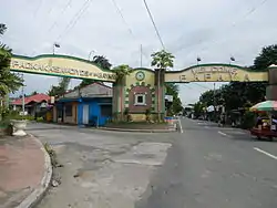 Welcome Arch | |
 Seal | |
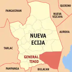 Map of Nueva Ecija with General Tinio highlighted | |
OpenStreetMap 
| |
.svg.png.webp) General Tinio Location within the Philippines | |
| Coordinates: 15°21′N 121°03′E | |
| Country | |
| Region | Central Luzon (Region III) |
| Province | Nueva Ecija |
| District | 4th District |
| Founded | 1921 |
| Named for | General Manuel Tinio |
| Barangays | 13 (see Barangays) |
| Government | |
| • Type | Sangguniang Bayan |
| • Mayor | Isidro T. Pajarillaga |
| • Vice Mayor | Melvin S. Pascual |
| • Representative | Maricel N. Nagaño |
| • Electorate | 35,834 voters (2019) |
| Area | |
| • Total | 245.29 km2 (94.71 sq mi) |
| Elevation | 56 m (184 ft) |
| Population | |
| • Total | 47,865 |
| • Density | 200/km2 (510/sq mi) |
| • Households | 10,305 |
| Economy | |
| • Income class | 1st municipal income class |
| • Poverty incidence | 14.92% (2015)[4] |
| • Revenue | ₱121,623,309.80 (2016) |
| Time zone | UTC+8 (PST) |
| ZIP code | 3104 |
| PSGC | |
| IDD : area code | +63 (0)44 |
| Climate type | tropical monsoon climate |
| Native languages | Southern Alta Tagalog Ilocano |
| Website | www |
It was known as Papaya until 1957.
The town is at the foot of the Sierra Madre Mountains, adjoining the Fort Magsaysay Army Reservation on the northeastern side.
History
According to the story passed on from one generation to another, the town got its name because of miscommunication between the natives and the Spanish colonizers. A native settler when asked by a Spanish soldier "Llama el pueblo?" replied "Papaya" referring to the particular fruit tree growing abundantly in the place (not understanding the Spanish language). The name stuck to the Spanish colonizers and the place from then on was called "Papaya".
Papaya was a sitio of Bo. Mapisong which was then a barrio of Gapan (now Gapan City). Bo. Mapisong became a town in 1851 changing its name to Peñaranda after a Spanish engineer Jose Maria Peñaranda. Papaya became one of its barangays. Papaya became a town on January 1, 1921, through the collaborative efforts of Capitan Mamerto Padolina who was then the Secretary of the Governor of the Province, Judge Segundo Bernardo and Francisco Padolina.
Congressman Celestino Juan sponsored a congressional act changing the name of Papaya to General Tinio in honor of General Manuel Tinio, a noble and prominent revolutionary leader against the Spaniards who hailed from the Nueva Ecija. The act was signed into law on June 20, 1957 as Republic Act No. 1665.[5] The new name of the town was inaugurated days later, on August 19, 1957.
Recently, the municipal council approved a resolution to rename the town back to its original name, "Papaya".
Barangays
General Tinio is politically subdivided into 13 barangays consisting of:
- Padolina (Barangay 1)
- Concepcion (Barangay 2)
- Rio Chico (Barangay 3)
- Pias (Barangay 4)
- Nazareth (Barangay 5)
- Bago (Barangay 6)
- Poblacion West (Barangay 7)
- Poblacion Central (Barangay 8)
- San Pedro (Barangay 9)
- Sampaguita (Barangay 10)
- Poblacion East (Barangay 11)
- Pulong Matong (Barangay 12)
- Palale (Barangay 13)
Climate
| Climate data for General Tinio, Nueva Ecija | |||||||||||||
|---|---|---|---|---|---|---|---|---|---|---|---|---|---|
| Month | Jan | Feb | Mar | Apr | May | Jun | Jul | Aug | Sep | Oct | Nov | Dec | Year |
| Average high °C (°F) | 29 (84) |
30 (86) |
31 (88) |
34 (93) |
33 (91) |
31 (88) |
30 (86) |
29 (84) |
29 (84) |
30 (86) |
30 (86) |
29 (84) |
30 (87) |
| Average low °C (°F) | 20 (68) |
20 (68) |
20 (68) |
22 (72) |
24 (75) |
24 (75) |
24 (75) |
24 (75) |
24 (75) |
23 (73) |
22 (72) |
21 (70) |
22 (72) |
| Average precipitation mm (inches) | 4 (0.2) |
4 (0.2) |
5 (0.2) |
11 (0.4) |
66 (2.6) |
99 (3.9) |
127 (5.0) |
113 (4.4) |
99 (3.9) |
84 (3.3) |
35 (1.4) |
14 (0.6) |
661 (26.1) |
| Average rainy days | 2.2 | 1.9 | 3.2 | 5.3 | 16.1 | 20.8 | 23.5 | 22.8 | 22.2 | 16.5 | 8.9 | 3.5 | 146.9 |
| Source: Meteoblue [6] | |||||||||||||
Demographics
| Year | Pop. | ±% p.a. |
|---|---|---|
| 1939 | 7,517 | — |
| 1948 | 8,645 | +1.57% |
| 1960 | 14,925 | +4.65% |
| 1970 | 19,353 | +2.63% |
| 1975 | 21,088 | +1.74% |
| 1980 | 23,406 | +2.11% |
| 1990 | 29,491 | +2.34% |
| 1995 | 32,913 | +2.08% |
| 2000 | 35,352 | +1.54% |
| 2007 | 39,356 | +1.49% |
| 2010 | 42,634 | +2.95% |
| 2015 | 47,865 | +2.23% |
| Source: Philippine Statistics Authority [3] [7] [8][9] | ||
Local government
The following have led the town from its birth in 1921 to what it had become today.[10]
| Commonwealth Era | ||
|---|---|---|
| President | Vice-President | Term |
| Cristobal Mangulabnan | Vice Martin Ramos | 1921–1922 |
| Getulio Bote, Sr. | Vice Martin Pajarillaga | 1922–1925 |
| Martin Pajarillaga | Vice Marcos Bote | 1925–1928 |
| Severo Pajarillaga | Vice Emeterio Abes | 1928–1931 |
| Pascual Rivera | Vice Daniel Padolina | 1931–1934 |
| Melquiades Ronquillo, Sr. | Vice Santiago Bolisay | 1934–1937 |
| Mayor | Vice Mayor | Term |
| Melquades Ronquillo, Sr. | Vice Damaso Bolisay | 1937–1940 |
| Getulio Bote | Vice Pedro Bulacan | 1940–1944 |
| Getulio Bote | Vice Angeles Bote | 1945 |
| Republic Era | ||
| Gerardo Rivera | Vice Angeles Bote | 1946–1947 |
| Gerardo Rivera | Vice Diosdado Bote | 1948–1951 |
| Gerardo Rivera with | Victorino Bote | 1952–1955 |
| Bienvenido B. Abes | Vice Victorino Bote | 1956–1959 |
| Gerardo Rivera | Vice Banaag Leodones | 1960–1963 |
| Santos Bote | Vice Getulio Bote, Jr. | 1964–1967 |
| Mariano Ronquillo | Vice Manuel Domingo | January 1–15, 1968 |
| Manuel Domingo | Vice Perfecto M. Bote | 1968–1971 |
| Nicanor B. Aves | Vice Alfonso Pajimna | 1972–1980 |
| Nathaniel Bote, Jr. | Vice Venancio Bote | 1981–1986 |
| OIC Gerardo Rivera | Vice Antonio Abes | 1986–1988 |
| Placido M. Calma | Vice Bernardino R. Abes | 1988–1995 |
| Placido M. Calma | Vice Elsa Bote | 1995–1998 |
| Virgilio A. Bote | Vice Bernardino R. Abes | 1998–2004 |
| Isidro Tinio Pajarillaga | Vice Indira P. Dayupay | 2004–2007 |
| Virgilio A. Bote | Vice Marcelo B. Abes | 2007–2010 |
| Virgilio A. Bote | Vice Engr. Ferdinand P. Bote | 2010–2016 |
| Engr. Ferdinand P. Bote | Vice Atty. Melvin S. Pascual | 2016–2018 |
| Atty. Melvin S. Pascual | Vice Anna Rouselle Busalpa | 2018-2019 |
| Engr. Isidro T. Pajarillaga | Atty. Melvin S. Pascual | 2019–Present |
Economy
Farming is the livelihood of majority of the residents. Even though located at the foot of the Sierra Madre Mountain Ridges, the topography is generally plain ideal to agricultural products such as palay and vegetables. A number of poultry broiler contract growers are located in the municipality. Other industries include furniture and fixtures, backyard poultry, cattle and livestock, vegetable production and minor agricultural livelihoods like duck raising. "Ikmo" or betel leaves production is one dying symbol of the town. The practice of chewing betel leaves by the older generation was not adopted by the younger generation even though of its reported natural anti-cancer formula.
The remittances of numerous sons and daughters of Papaya abroad also help keep the economy of the town afloat. Papayanos can be relied to answer calls of assistance for the town's development.
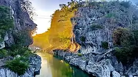
Minalungao National Park is also one of the biggest attraction of the town catering tens and hundreds of thousands each day.
Culture
Roman Catholic is the most prevalent religion, with Iglesia ni Cristo, IEMELIF, Baptist, Methodist, and others attracting its own followers. The town's patron saint, the Santo Cristo or the Holy Cross is being feted every May.
The town is best known for having the most number of brass bands in the Philippines with 15 organized bands. These bands are sought after to enhance entertainment ambience in fiestas and other traditional rites such as wakes. The Family band is the most popular one and have produced champions in majorette exhibition, solo flute competition, solo clarinet competition, solo trumpet competition, French horn competition, etc., in national brass band competitions.
The town also has other places of interest notably Minalungao National Park which is a favorite swimming destinations in summer, specially during Black Saturday when it is usually filled with local bathers and visitors. Minalungao, literally meaning "mine of gold in a cave", has several caves which can explored. The river also has a portion where a stone ledge located about 15 meters high from the river can be used as spring board.
Papaya Festival is also celebrated coincide with its Foundation Anniversary, Parade of different school students around the town wearing colourful costume inspired by the fruits Papaya which this town got its name until it was change to General Tinio
Images
 Town hall
 Sports center
 Old Santo Cristo Parish Church
 New Holy Cross Parish Church
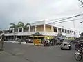 Public market
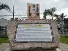 Cory Aquino memorial
References
- Municipality of General Tinio | (DILG)
- "Province: Nueva Ecija". PSGC Interactive. Quezon City, Philippines: Philippine Statistics Authority. Retrieved 12 November 2016.
- Census of Population (2015). "Region III (Central Luzon)". Total Population by Province, City, Municipality and Barangay. PSA. Retrieved 20 June 2016.
- "PSA releases the 2015 Municipal and City Level Poverty Estimates". Quezon City, Philippines. Retrieved 1 January 2020.
- "An Act Changing the Name of the Municipality of Papaya in the Province of Nueva Ecija to General Tinio". LawPH.com. Retrieved 2011-04-12.
- "General Tinio: Average Temperatures and Rainfall". Meteoblue. Retrieved 4 May 2020.
- Census of Population and Housing (2010). "Region III (Central Luzon)". Total Population by Province, City, Municipality and Barangay. NSO. Retrieved 29 June 2016.
- Censuses of Population (1903–2007). "Region III (Central Luzon)". Table 1. Population Enumerated in Various Censuses by Province/Highly Urbanized City: 1903 to 2007. NSO.
- "Province of Nueva Ecija". Municipality Population Data. Local Water Utilities Administration Research Division. Retrieved 17 December 2016.
- "Elected Officials of General Tinio 2013-2016". Generaltinio.gov.ph. 2010-07-12. Retrieved 2016-11-23.
External links
| Wikimedia Commons has media related to General Tinio, Nueva Ecija. |
- General Tinio Profile at PhilAtlas.com
- Philippine Standard Geographic Code
- Philippine Census Information
Places adjacent to General Tinio, Nueva Ecija | ||||||||||
|---|---|---|---|---|---|---|---|---|---|---|
| ||||||||||
Palayan (capital) | |
| Municipalities | |
| Component cities | |