Palayan
Palayan, officially the City of Palayan (Tagalog: Lungsod ng Palayan), is a 5th class component city and capital of the province of Nueva Ecija, Philippines. According to the 2015 census, it has a population of 41,041 people, [3] making it as the most sparsely populated city in the Philippines.
Palayan | |
|---|---|
| City of Palayan | |
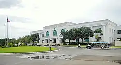 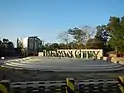 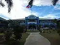 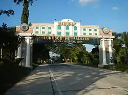 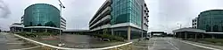 (From top, left to right): Provincial Capitol of Nueva Ecija, City Center Welcome Sign, Palayan City Hall, Palayan City Business Park | |
 Flag  Seal | |
| Motto(s): Kilos Palayano, Aasenso Tayo (Move for Progress, Palayanese) | |
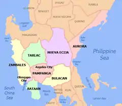
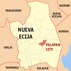 Map of Nueva Ecija with Palayan highlighted | |
OpenStreetMap 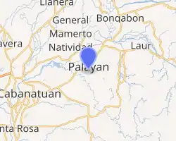
| |
.svg.png.webp) Palayan Location within the Philippines | |
| Coordinates: 15°32′N 121°05′E | |
| Country | |
| Region | Central Luzon (Region III) |
| Province | Nueva Ecija |
| District | 3rd district |
| Foundation and cityhood | June 19, 1965 |
| Barangays | 20 (see Barangays) |
| Government | |
| • Type | Sangguniang Panlungsod |
| • Mayor | Adrianne Mae J. Cuevas |
| • Vice Mayor | Moises A. Carmona Jr. |
| • Representative | Rosanna V. Vergara |
| • Electorate | 35,158 voters (2019) |
| Area | |
| • Total | 101.40 km2 (39.15 sq mi) |
| Elevation | 173 m (568 ft) |
| Population | |
| • Total | 41,041 |
| • Density | 400/km2 (1,000/sq mi) |
| • Households | 9,280 |
| Economy | |
| • Income class | 5th city income class |
| • Poverty incidence | 14.49% (2015)[4] |
| • Revenue | ₱294,775,353.80 (2016) |
| Time zone | UTC+8 (PST) |
| ZIP code | 3132 |
| PSGC | |
| IDD : area code | +63 (0)44 |
| Climate type | tropical monsoon climate |
| Native languages | Tagalog Ilocano |
| Website | www |
Palayan was created on June 19, 1965 by the Congress of the Philippines and is one of seven planned cities in the Philippines (the other six being Manila, Baguio, Quezon City, Trece Martires, Koronadal and the Island Garden City of Samal).[5]
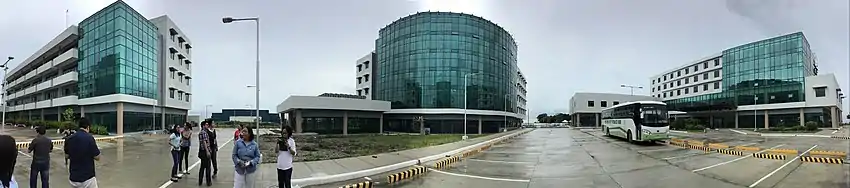
The new provincial capitol, convention center, and sports center of Nueva Ecija are located in the city.
History
On March 25, 1952, a special consultation meeting was conducted by Governor Leopoldo Diaz along with Congressman Jesus Ilagan, Board Members Dioscoro de Leon and Antonio Corpuz, Don Felipe Buencamino, and the municipal mayors of Nueva Ecija to discuss the transfer the provincial capital from Cabanatuan. As a result, the group unanimously agreed to establish the new capital on the site of the Government Stock Farm located within the municipalities of Laur and Bongabon. The municipalities of Gapan, San Jose, Santa Rosa, Guimba, Talavera, General Tinio, Baloc (Santo Domingo), and Muñoz were also considered as potential sites for the new capital.
In 1955, President Ramon Magsaysay declared a portion of the Government Stock Farm open for settlement pursuant to presidential Proclamation No. 237.[6]
On June 19, 1965, the Congress of the Philippines enacted Republic Act 4475 creating Palayan City as the new capital of Nueva Ecija.[7] "Palayan" (rice paddy) was chosen as the name of the new provincial capital to reflect the moniker bestowed upon the province of Nueva Ecija as the “Rice Granary of the Philippines”. The city government was constituted on December 5, 1965 with then Governor Eduardo L. Joson acting as the city's Ex-Officio Mayor while the Provincial Board constituted the first City Council. Under this administration, Iglesia ni Cristo (INC) purchased a large tract of land at the city's parameters near Laur to house INC members from Hacienda Luisita due to conflicts arising from union disbandments.
In 1969, Mayor Elpidio O. Cucio and Vice-Mayor Felipe Bautista, both formerly appointed to their respective offices, were amongst the first elected local officials of the city along with councilors Flor Agustin, Tranquilino dela Cruz, Antonio Pascual, Federico Dacanay, Luis Lacalle and Thomas Lumawig. The city also hosted the National Boy Scout Jamboree attended by thousands of local and foreign scouts during this year.
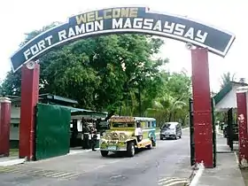
In August 1969, the city was enlarged by virtue of Republic Act 6052 authored by then Congressman Angel Concepcion which provided for the inclusion of the Military Reservation in Laur and the Fort Magsaysay Cantonment area located in Santa Rosa.[8]
In 1972, by virtue of Proclamation No. 893, a portion of the Government Stock Farm was allocated for the displaced population of Pantabangan due to the construction of the Pantabangan Dam. The resettlement site was eventually converted into barangay Marcos Village.
In 1983, the training ground of the Philippine Army was transferred from Fort Bonifacio in Metro Manila to Fort Ramon Magsaysay. This paved the way for the development of the reservation area into a training complex to serve the army's training requirements.
In 1993, the Asianwide Green Scouts Movement was founded during the first RP-Japan Bilatateral Ecology Work Camp held in the city. The event also led to the establishment of the projects Kawayang Buhay and the Asian Ecology Forest which is supported by the Asian Friendship Society.
On 1995, Barangay Popolon, formerly a barangay of Bongabon, was annexed to the city by virtue of Republic Act No. 8030 ratified by a plebiscite held on October 1, 1995.[9] Moreover, Bagong Buhay, one of the three resettlement areas in the city, was converted to a regular barangay after a plebiscite on November 26, 1995.
The new provincial capitol building of Nueva Ecija was completed in 2002, solidifying the city's status as both the de facto and de jure capital of the province. The old provincial capitol is located in Burgos Avenue, Cabanatuan City and is still utilized by the provincial government.
Barangays
Palayan City is politically subdivided into 19 barangays.
- Atate
- Aulo
- Bagong Buhay
- Bo. Militar (Fort Magsaysay)
- Caballero
- Caimito
- Doña Josefa
- Ganaderia
- Imelda Valley
- Langka
- Malate (Poblacion)
- Maligaya
- Manacnac
- Mapaet
- Marcos Village
- Popolon (Pagas)
- Santolan
- Sapang Buho
- Singalat
Climate
| Climate data for Palayan City, Nueva Ecija | |||||||||||||
|---|---|---|---|---|---|---|---|---|---|---|---|---|---|
| Month | Jan | Feb | Mar | Apr | May | Jun | Jul | Aug | Sep | Oct | Nov | Dec | Year |
| Average high °C (°F) | 29 (84) |
30 (86) |
31 (88) |
33 (91) |
33 (91) |
31 (88) |
30 (86) |
29 (84) |
29 (84) |
30 (86) |
30 (86) |
29 (84) |
30 (87) |
| Average low °C (°F) | 19 (66) |
19 (66) |
20 (68) |
22 (72) |
23 (73) |
24 (75) |
24 (75) |
24 (75) |
23 (73) |
22 (72) |
21 (70) |
20 (68) |
22 (71) |
| Average precipitation mm (inches) | 4 (0.2) |
6 (0.2) |
7 (0.3) |
12 (0.5) |
61 (2.4) |
89 (3.5) |
96 (3.8) |
99 (3.9) |
81 (3.2) |
88 (3.5) |
37 (1.5) |
13 (0.5) |
593 (23.5) |
| Average rainy days | 2.5 | 3.0 | 4.1 | 6.3 | 15.8 | 19.4 | 22.5 | 21.6 | 20.1 | 17.5 | 9.6 | 4.0 | 146.4 |
| Source: Meteoblue [10] | |||||||||||||
Demographics
| Year | Pop. | ±% p.a. |
|---|---|---|
| 1970 | 8,382 | — |
| 1975 | 12,140 | +7.71% |
| 1980 | 14,959 | +4.26% |
| 1990 | 20,393 | +3.15% |
| 1995 | 26,851 | +5.29% |
| 2000 | 31,253 | +3.31% |
| 2007 | 32,790 | +0.66% |
| 2010 | 37,219 | +4.72% |
| 2015 | 41,041 | +1.88% |
| Source: Philippine Statistics Authority [3] [11] [12][13] | ||
Sister city
Gallery
References
- City of Palayan | (DILG)
- "Province: Nueva Ecija". PSGC Interactive. Quezon City, Philippines: Philippine Statistics Authority. Retrieved 12 November 2016.
- Census of Population (2015). "Region III (Central Luzon)". Total Population by Province, City, Municipality and Barangay. PSA. Retrieved 20 June 2016.
- "PSA releases the 2015 Municipal and City Level Poverty Estimates". Quezon City, Philippines. Retrieved 1 January 2020.
- "Palayan City History | Tourist Spots, Language and Festivals | Philippines Cities". Retrieved 2020-04-03.
- "Proclamation No. 237, s. 1955". Official Gazette of the Republic of the Philippines. Archived from the original on 19 June 2017. Retrieved 10 July 2019.
- "Republic Act No. 4475". Chan Robles Virtual Law Library. Archived from the original on 27 September 2007. Retrieved 10 July 2019.
- "Republic Act No. 6052". Chan Robles Virtual Law Library. Archived from the original on 10 July 2019. Retrieved 10 July 2019.
- "Republic Act No. 8030". Chan Robles Virtual Law Library. Archived from the original on 14 June 2008. Retrieved 10 July 2019.
- "Palayan: Average Temperatures and Rainfall". Meteoblue. Retrieved 4 May 2020.
- Census of Population and Housing (2010). "Region III (Central Luzon)". Total Population by Province, City, Municipality and Barangay. NSO. Retrieved 29 June 2016.
- Censuses of Population (1903–2007). "Region III (Central Luzon)". Table 1. Population Enumerated in Various Censuses by Province/Highly Urbanized City: 1903 to 2007. NSO.
- "Province of Nueva Ecija". Municipality Population Data. Local Water Utilities Administration Research Division. Retrieved 17 December 2016.
External links
| Wikivoyage has a travel guide for Palayan. |
| Wikimedia Commons has media related to Palayan City. |
- Palayan Profile at PhilAtlas.com
- Official website
- Philippine Standard Geographic Code
- Philippine Census Information
- Local Governance Performance Management System
Places adjacent to Palayan | |
|---|---|