Glottertal
Glottertal is a town in the district of Breisgau-Hochschwarzwald in Baden-Württemberg in southern Germany.
Glottertal | |
|---|---|
 | |
 Coat of arms | |
Location of Glottertal within Breisgau-Hochschwarzwald district 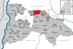 | |
 Glottertal  Glottertal | |
| Coordinates: 48°2′55″N 7°57′18″E | |
| Country | Germany |
| State | Baden-Württemberg |
| Admin. region | Freiburg |
| District | Breisgau-Hochschwarzwald |
| Subdivisions | 4 |
| Government | |
| • Mayor | Karl-Josef Herbstritt |
| Area | |
| • Total | 30.76 km2 (11.88 sq mi) |
| Highest elevation | 1,243 m (4,078 ft) |
| Lowest elevation | 280 m (920 ft) |
| Population (2019-12-31)[1] | |
| • Total | 3,167 |
| • Density | 100/km2 (270/sq mi) |
| Time zone | UTC+01:00 (CET) |
| • Summer (DST) | UTC+02:00 (CEST) |
| Postal codes | 79286 |
| Dialling codes | 07684 |
| Vehicle registration | FR |
| Website | www.glottertal.de |
History
From 1567 till the Napoleonic Wars the area was part of Further Austria and therefore part of the Habsburg Monarchy. Although the history of mining in the Glottertal goes back to Roman times and villages in the area are mentioned 1112 in the chronics of Abbey of Saint Peter in the Black Forest the municipal Glottertal was formed in 1970. The four former independent villages Unterglottertal, Oberglottertal, Ohrensbach und Föhrental were associated to the Glottertal municipal.
Points of interest
Buildings
The 1914 built Carlsbau in Glottertal was the set for the 1980s medical drama television series The Black Forest Clinic. The outside of the building and the surrounding area was filmed while the interior was filmed in a set in Hamburg. The building was used as a clinic till it was closed down in 2004.[2][3]
Mining
The first archaeologic artefacts demonstrating iron smelting date back to the Roman time. The mining of silver started in the 11th century. The construction of a 15 kilometer long water channel to supply the mines with water do drive the pumps which was built in 1284 marks the importance of mining in the area. Flooding of the mines during a war period ended this activities at the end of the 12th century. The mining of silver continued on a smaller scale and in the 18th century the mining of iron and baryte was started. The last mines in the area closed before 1900.
Geography
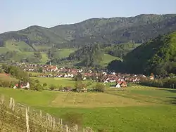
The town is located in a small valley south east of the Kandel mountain. The valley opens to the west and the water of the small river Glotter reaches the Elz and little later the Rhine.
Gallery
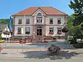 Glottertal, townhall
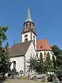 Glottertal, church: die Sankt Blasius Kirche
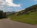 Between Glottertal and Sankt Peter, road panorama
External links
References
| Wikimedia Commons has media related to Glottertal. |
- "Bevölkerung nach Nationalität und Geschlecht am 31. Dezember 2019". Statistisches Landesamt Baden-Württemberg (in German). September 2020.
- Stuff, Brita. Die Schwarzwaldklinik – Heile Welt zu verkaufen, Die Welt, August 22, 2009. Accessed March 5, 2010. (German)
- Luck, Harry. Das Geisterhaus im Glottertal, Focus, August 24, 2007. Accessed March 5, 2010. (German)