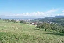
Au (Schwarzwald)
Au is a municipality in Breisgau-Hochschwarzwald, Baden-Württemberg, Germany. It is located a few kilometres south of Freiburg im Breisgau, in the south-western part of Baden-Württemberg. The municipality belongs to the administrative region of Hexental based in the neighbouring town of Merzhausen.
Au | |
|---|---|
 | |
.svg.png.webp) Coat of arms | |
Location of Au within Breisgau-Hochschwarzwald district 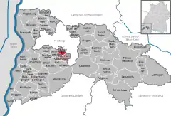 | |
 Au  Au | |
| Coordinates: 47°57′N 7°50′E | |
| Country | Germany |
| State | Baden-Württemberg |
| Admin. region | Freiburg |
| District | Breisgau-Hochschwarzwald |
| Government | |
| • Mayor | Jörg Kindel |
| Area | |
| • Total | 3.99 km2 (1.54 sq mi) |
| Highest elevation | 643 m (2,110 ft) |
| Lowest elevation | 285 m (935 ft) |
| Population (2019-12-31)[1] | |
| • Total | 1,480 |
| • Density | 370/km2 (960/sq mi) |
| Time zone | UTC+01:00 (CET) |
| • Summer (DST) | UTC+02:00 (CEST) |
| Postal codes | 79280 |
| Dialling codes | 0761 |
| Vehicle registration | FR |
| Website | VWG Hexental |
Geography
Location
Au lies in the northern part of Hexental between Schönberg in the west and Black Forest to the east.
Local communities
The village of Au, Schönberg, Hof and the Hägenhof houses, and the Burghöfe, Finsterbach, Hasgelhöfe, Heimbachof, Kaischenhof, Kopfackerhof and Schwabenhöfe all belong to the municipality of Au. In the local area, there also are the abandoned village of Witraha and the abandoned castle of Obhusen. The naming of the place Niderhusun in 861, probably refers to Niederhausen, a place in the municipality of Rheinhausen (Breisgau) in the district of Emmendingen.[2]
Neighbouring communities
Neighbouring communities include Horben in the southeast, Wittnau, Baden-Württemberg in the southwest, Ebringen in the west and Merzhausen in the north, as well as Freiburg im Breisgau to the east. All of these communities are in the district of Breisgau-Hochschwarzwald.
Geology
The Upper Rhine Plain fault line runs through Au. The Schönberg side is shaped by the remains of large landslides.
History
Au was firstly recorded in print by the Cloister of St Gallen in 861. In the Middle Ages, there was very likely a castle, but the remains no longer exist. The name "Burghöfen" makes this assumption more likely. In the Thirty Years' War, Au was the battleground for the Battle of Freiburg for two days.
Politics
After the local elections on the 25th May, 2014, the following results came in. The turnout was at 68.9%, up from 2009 (68.4%)
| Christian Democratic Union of Germany | 34.4% | -6.1 | 3 Seats | -1 |
| Wählervereinigung Au | 36% | +4.7 | 4 Seats | +1 |
| WBU* | 29.6% | -3.3 | 3 Seats | =0 |
*Wählergemeinschaft für Bürgernähe und Umweltschutz
Mayors
- 1980-2003: Elmar Bitzenhofer
- Since 2004: Jörg Kindel
Economy and Infrastructure
Economy
Because almost half of the local land is agriculturally useful, the economic sector still plays a significant role. Among that, the local area also makes wine.
References
- "Bevölkerung nach Nationalität und Geschlecht am 31. Dezember 2019". Statistisches Landesamt Baden-Württemberg (in German). September 2020.
- Das Land Baden-Württemberg. Amtliche Beschreibung nach Kreisen und Gemeinden. Band IV: Regierungsbezirk Freiburg Kohlhammer, Stuttgart 1978, ISBN 3-17-007174-2. S. 134