Feldberg, Baden-Württemberg
Feldberg is a municipality in the district of Breisgau-Hochschwarzwald in Baden-Württemberg in southern Germany. It is located near the Feldberg, the highest summit in Baden-Württemberg. It comprises the settlements of Altglashütten, Neuglashütten, Falkau, Bärental, and Felberg. At an elevation of 1277m, the last is considered the highest village in Germany.
Feldberg | |
|---|---|
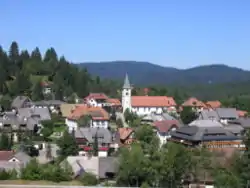 Center of Altglashütten in August 2015 | |
 Coat of arms | |
Location of Feldberg within Breisgau-Hochschwarzwald district _in_FR.svg.png.webp) | |
 Feldberg  Feldberg | |
| Coordinates: 47°51′22″N 8°6′42″E | |
| Country | Germany |
| State | Baden-Württemberg |
| Admin. region | Freiburg |
| District | Breisgau-Hochschwarzwald |
| Government | |
| • Mayor | Johannes Albrecht |
| Area | |
| • Total | 24.97 km2 (9.64 sq mi) |
| Elevation | 1,277 m (4,190 ft) |
| Population (2019-12-31)[1] | |
| • Total | 1,862 |
| • Density | 75/km2 (190/sq mi) |
| Time zone | UTC+01:00 (CET) |
| • Summer (DST) | UTC+02:00 (CEST) |
| Postal codes | 79868 |
| Dialling codes | 07676 / 07655 |
| Vehicle registration | FR |
| Website | www.feldberg-schwarzwald.de |
Geography
The Feldberg municipality has the slogan "The highest in the Black Forest" (German: Das Höchste im Schwarzwald) and is located in the Southern Black Forest Nature Park at the Feldberg Pass. It is located between Wiesental (to the south) and Gutachtal (to the north). The largest section of the municipality is the "Falkau" area, where the town hall is located.
Community Structure
The current Feldberg municipality includes the three former municipalities of Feldberg, Altglashütten, and Falkau and consists of 30 villages, sections, farms, and cottages and houses.
Climate
Feldberg has a subarctic climate (Dfc) due to its high altitude.
| Climate data for Feldberg, Baden-Württemberg, 1490 m asl (1981–2010 normals) | |||||||||||||
|---|---|---|---|---|---|---|---|---|---|---|---|---|---|
| Month | Jan | Feb | Mar | Apr | May | Jun | Jul | Aug | Sep | Oct | Nov | Dec | Year |
| Record high °C (°F) | 12.9 (55.2) |
16.7 (62.1) |
14.5 (58.1) |
19.3 (66.7) |
22.9 (73.2) |
27.0 (80.6) |
27.4 (81.3) |
26.4 (79.5) |
24.6 (76.3) |
21.2 (70.2) |
18.1 (64.6) |
13.9 (57.0) |
27.4 (81.3) |
| Mean maximum °C (°F) | 7.5 (45.5) |
7.9 (46.2) |
9.8 (49.6) |
13.1 (55.6) |
17.7 (63.9) |
20.3 (68.5) |
22.4 (72.3) |
21.8 (71.2) |
18.3 (64.9) |
16.3 (61.3) |
12.3 (54.1) |
8.7 (47.7) |
23.5 (74.3) |
| Average high °C (°F) | −0.1 (31.8) |
−0.5 (31.1) |
1.5 (34.7) |
4.7 (40.5) |
9.4 (48.9) |
12.4 (54.3) |
14.9 (58.8) |
14.6 (58.3) |
11.0 (51.8) |
8.1 (46.6) |
3.0 (37.4) |
−0.7 (30.7) |
6.5 (43.7) |
| Daily mean °C (°F) | −2.5 (27.5) |
−2.9 (26.8) |
−0.9 (30.4) |
2.1 (35.8) |
6.6 (43.9) |
9.6 (49.3) |
12.1 (53.8) |
12.0 (53.6) |
8.6 (47.5) |
5.6 (42.1) |
0.7 (33.3) |
−1.7 (28.9) |
4.1 (39.4) |
| Average low °C (°F) | −4.9 (23.2) |
−5.3 (22.5) |
−3.3 (26.1) |
−0.6 (30.9) |
3.9 (39.0) |
6.8 (44.2) |
9.2 (48.6) |
9.4 (48.9) |
6.1 (43.0) |
3.1 (37.6) |
−1.7 (28.9) |
−4.1 (24.6) |
1.6 (34.8) |
| Mean minimum °C (°F) | −13.0 (8.6) |
−13.1 (8.4) |
−10.5 (13.1) |
−7.7 (18.1) |
−2.5 (27.5) |
0.4 (32.7) |
3.4 (38.1) |
3.4 (38.1) |
0.1 (32.2) |
−4.1 (24.6) |
−9.0 (15.8) |
−12.8 (9.0) |
−16.4 (2.5) |
| Record low °C (°F) | −25.7 (−14.3) |
−30.7 (−23.3) |
−20.3 (−4.5) |
−13.7 (7.3) |
−8.3 (17.1) |
−3.5 (25.7) |
−1.7 (28.9) |
−0.2 (31.6) |
−5.3 (22.5) |
−11.1 (12.0) |
−15.1 (4.8) |
−23 (−9) |
−30.7 (−23.3) |
| Average precipitation mm (inches) | 127.8 (5.03) |
96.7 (3.81) |
115.3 (4.54) |
97.0 (3.82) |
163.1 (6.42) |
147.8 (5.82) |
157.0 (6.18) |
145.7 (5.74) |
141.7 (5.58) |
164.7 (6.48) |
135.5 (5.33) |
150.8 (5.94) |
1,643.1 (64.69) |
| Average precipitation days | 13.66 | 12.12 | 14.98 | 13.57 | 16.10 | 13.83 | 13.73 | 13.13 | 11.63 | 13.34 | 13.70 | 14.75 | 164.54 |
| Mean monthly sunshine hours | 95.5 | 100.8 | 117.4 | 145.9 | 169.8 | 178.9 | 210.9 | 198.4 | 148.0 | 127.2 | 88.0 | 76.2 | 1,657 |
| Source 1: Météo climat stats[2] | |||||||||||||
| Source 2: Météo Climat [3] | |||||||||||||
History
The first mention of Feldberg was made in 983, but there was a separate municipality with the same name until January 1, 1939, when isolated pastures were combined with the municipality Bärental (970 m above sea level). They were previously owned by the municipalities Bernau, Brandenberg, Hinterzarten, Menzenschwand, St. William, Todtnau and Zastler. What was left of Brandenberg after incorporation to Feldberg became a new district in Todtnau.[4]
Politics
Local Council
The general election on May 25, 2014 resulted in the following allocation of seats within the local council:
| Political Party | Number of Seats |
|---|---|
| The Feldberg List | 4 seats |
| Free Voters | 3 seats (-1) |
| Citizen List Feldberg | 3 seats |
Administration
There is an inter-municipality agreement with the neighbouring Schluchsee municipality.
Coat of arms
In 1974, the ministry of the interior granted Dr. Alfred Simon permission to design the following crest: a red plate head holding two crossed silver snowshoes lies above a split silver and blue area. The blue section, on the left, holds three silver discs, and the silver section, on the right, holds a green fir tree.
The founder municipalities Feldberg, Bärental, and Altglashütten are represented by the three primary colours red, white, and blue. The blue also most likely represents the connection to the former House of Fürstenberg (Swabia). The meaning of the three discs leaves room for speculation. They are either reminiscent of glass spheres and glaziers or of the three lakes that meet within the boundary of Feldberg: Titisee, Windgfällweiher und Schluchsee. They could also symbolize the unity of the three communities.


Partner Town
Feldberg has a sister city agreement with the municipality of La Clusaz in France im Département Haute-Savoie, which is, like Feldberg, a winter sport centre.
Economy and Infrastructure
Traffic
Federal highways 500 and 317 intersect in Bärental. The construction of the Dreiseenbahn, which runs from Titisee to Seebrugg, was completed in 1926 and in Bärental, it is Germany's highest railway on a standard gauge track.
Education
Altglashütten has a primary school and a kindergarten.
Culture and Sightseeing
Natural Monuments
The sponsoring association of the Southern Black Forest Nature Park has its seat in Feldberg.
- Feldsee, a tarn excavated by the Feldberg glacier below the summit.
- Zastler Loch, formed as the Feldberg glacier excavated valleys in the former village of Zastler
- Bärhalde, a botanically interesting forest summit with rocks and small moors
- Rotmeer, a swampy area
- Seebach waterfall, near the town of Behabühl
- Falkau waterfall in Haslach
- Headwaters of the Wiese, Alb (Upper Rhine), and Wutach rivers
Regular Events
The Lawrence of Rome festival occurs yearly on the Feldberg in addition to the nearby annual Altglashütten town festival.
Notable people
Community Members
- Julius Kibiger (1902–1983), artist and painter, produced over 4000 works [5] and became one of the most productive and well-known painters of the Markgräflerland region. He was known mostly for his watercolour and oil paintings, but completed many sketches and pastel drawings as well.
- Hansy Vogt (born 1967), lead singer of the folk music group Die Feldberger and television presenter
with connections to Feldberg
- Hans Vehrenberg (1910–1991), publisher and amateur astronomer, ran a private observatory in Falkau. He was famous for his photography and star atlases (Falkauer Atlas und Atlas Stellarum) as well as his books.
- August Euler (1868–1957), pioneer aviator, lived in a house on the Seebuck mountain until his death in 1957
- Elisabeth Heimpel (1902–1972), educator and social worker, died in the forest near Falkau as a result of a stroke
- Ernst Rudolf Huber (1903–1990)
Literature[6]
- August Vetter: Feldberg im Schwarzwald, Selbstverlag der Gemeinde Feldberg (Schwarzwald), 1982/1996
References
- "Bevölkerung nach Nationalität und Geschlecht am 31. Dezember 2019". Statistisches Landesamt Baden-Württemberg (in German). September 2020.
- "Moyennes 1961-1990 Allemagne" (in French). Retrieved 11 November 2019.
- "Météo Climat stats for Feldberg". Météo Climat. Retrieved 11 November 2019.
- Vetter (1996). p. 318. Missing or empty
|title=(help) - Münch, Volker. "Julius Kibigers zeichnerische Seite". Badische Zeitung. Ausgabe Müllheim. Retrieved 26 September 2016.
- Albrecht, Johannes. "Published results of the election 2019" (PDF). Retrieved 17 July 2019.