Gohana
Gohana is a city and a municipal council in the Sonipat district of the Indian state of Haryana.
Gohana | |
|---|---|
City | |
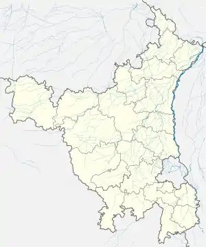 Gohana Location in Haryana, India  Gohana Gohana (India) | |
| Coordinates: 29.13°N 76.9°E | |
| Country | |
| State | Haryana |
| District | Sonipat |
| Government | |
| • Type | Chairman |
| • Body | Nagar Parishad Gohana |
| Elevation | 225 m (738 ft) |
| Population (2017) | |
| • Total | 65,708 |
| Languages | |
| • Official | Hindi, Regional Haryanvi |
| Time zone | UTC+5:30 (IST) |
| PIN | 131301 |
| Telephone code | 91-01263 |
| ISO 3166 code | IN-HR |
| Vehicle registration | HR 11 |
Geography
Gohana is located at 29.13°N 76.7°E.[1] Its topography consists mainly of low plains, but its south-central area has a small plateau. Gohana's 43 km2 (27.95sq mile) land area has an average elevation of 225 metres (738 feet).
Demographics
Gohana city is situated in the Sonipat district of Haryana. It is a main subdivision with a population of more than 300,000 (as of 2011). It has its own municipality and a constituency for Haryana Vidhan Sabha. There is around 86 Villages in Gohana. It is located in the west of the Sonipat District, 40 km from the town of Sonipat. Earlier, it was part of Rohtak district. Gohana is the oldest tehsil of Haryana. It was declared a tehsil in 1826 by the British, and some structures which show evidence of that time are still standing in the city: the City police station, Government Boys' Senior Secondary School, Government Girls' Senior Secondary School, and the Jain Senior Secondary School are some examples. Gohana City has its own Courts and Mini Secretariat, situated on Sonipat Road, in the eastern part of the city. "Nagar Palika Gohana" is the governing body of the city.
In ancient times, Gohana was known as Gavambhavana and was considered a sacred place. Prithviraj Chauhan constructed a fort here, which was later destroyed by Muhammad Ghori after defeating Prithviraj in 1192. Later, in 1947, all Muslim families left this place and migrated to Pakistan. Being a tehsil city, people from diverse communities reside in the city.
As of 2011 India census,[2] Gohana had a population of 121,637. Males constitute 53% of the population and females 47%. Gohana has an average literacy rate of 78%, higher than the national average of 74.5%: male literacy is 89%, and female literacy is 65%.
Traveling and distance from major cities nearby
Gohana is well connected with major districts and other small towns/villages. There is a national highway NH 71-A that connects Gohana to Rohtak and Panipat - two major districts, and National highway NH 352A that connects it to district Sonipat and Jind. Trains connect Gohana with Rohtak, Bhiwani and Panipat. New railway line from Jind to Sonipat through Gohana is fully functional since 26 June 2016.[3] City has a railway station which was founded in early 70s and is a Junction now.
Distance from major cities
| City | Distance | Direction |
|---|---|---|
| Chandigarh | 202 km | north |
| Panipat | 42 km | northeast |
| Rohtak | 33 km | southwest |
| New Delhi | 90 km | southeast |
| Sonipat | 40 km | east |
Politics
The region has its own seat in Vidhan Sabha, and it comes under Sonipat in the Lok Sabha constituency. The politics of Gohana mostly revolves around caste politics. Jagbir Singh Malik has been the three time winning member of Vidhan Sabha from Indian National Congress and their member of Parliament is Ramesh Kaushik from the Bhartiya Janta Party.
Famous politicians of Gohana
References
- Falling Rain Genomics, Inc - Gohana
- "DISTRICT CENSUS HANDBOOK" (PDF).
- "Sonepat and Jind train flagged off". PTI. Sonepat. Press Trust of India. 26 June 2016. Retrieved 2 August 2016.
External links
Sonipat district topics | ||
|---|---|---|
| Cities and towns | 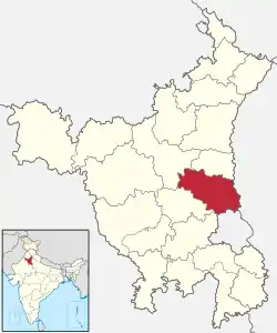 | |
| Education | ||
| Transport | ||
| Lok Sabha constituencies | ||