Goma
Goma is the capital of North Kivu province in the eastern Democratic Republic of the Congo. It is located on the northern shore of Lake Kivu, next to the Rwandan city of Gisenyi. The lake and the two cities are in the Albertine Rift, the western branch of the East African Rift system. Goma lies only 13–18 km (8.1–11.2 mi) south of the active Nyiragongo Volcano. The recent history of Goma has been dominated by the volcano and the Rwandan genocide of 1994, which in turn fuelled the First and Second Congo Wars. The aftermath of these events was still having effects on the city and its surroundings in 2010. The city was captured by rebels of the March 23 Movement during the M23 rebellion in late 2012, but has since been retaken by government forces.
Goma | |
|---|---|
Provincial capital and city | |
| Ville de Goma | |
.jpg.webp) Goma with Mount Nyiragongo in the background, in 2015 | |
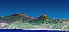
 Goma Location in the Congo | |
| Coordinates: 01°40′46″S 29°14′01″E | |
| Country | DR Congo |
| Province | North Kivu |
| Communes | Goma, Karisimbi |
| Government | |
| • Mayor | Timothée Mwisa Kyese |
| Area | |
| • City | 75.72 km2 (29.24 sq mi) |
| Population (2021) | |
| • Metro | 670,000[1] |
| Time zone | UTC+2 (CAT) |
| National language | Swahili |
| Climate | Aw |
| Year | Pop. | ±% |
|---|---|---|
| 1950 | 5,000 | — |
| 1960 | 16,000 | +220.0% |
| 1970 | 49,000 | +206.2% |
| 1980 | 68,000 | +38.8% |
| 1990 | 111,000 | +63.2% |
| 2000 | 198,000 | +78.4% |
| 2010 | 355,000 | +79.3% |
| 2020 | 634000 [1] | — |
A pastor infected during the ongoing 2018–2020 Kivu Ebola epidemic in the region was found in mid-July 2019 to have travelled to Goma.[1]
History
1994 refugee crisis
The Rwandan genocide of 1994 was perpetrated by the provisional Rwandan government on the Tutsi population and Hutu moderates. In response the Rwandan Patriotic Front (RPF), formed by Tutsi refugees in Uganda, which already controlled large areas of northern Rwanda following its 1990 invasion and the ongoing Civil War, overthrew the Hutu government in Kigali and forced it out. One of the many UN missions attempted to provide a safe zone in the volatile situation and provided safe passage for the refugees. From 13 June to 14 July 1994, 10,000 to 12,000 refugees per day crossed the border to Goma. The massive influx created a severe humanitarian crisis,[2] as there was an acute lack of shelter, food and water. However, the Zaïrean government took it upon itself to garner attention for the situation. Shortly after the arrival of nearly one million refugees,[3] a deadly cholera outbreak claimed thousands of lives in the Hutu refugee camps around Goma. RPF aligned forces, mainly actors in the conflict, crossed the border and in acts of revenge also claimed several lives.
First Congo War
Hutu militias and members of the Hutu provisional government were among the refugees, and they set up operations from the camps around Goma attacking ethnic Tutsis in the Kivus and Rwandan government forces at the border. For political reasons the Kinshasa government of the then Zaire led by Joseph Mobutu did not prevent the attacks, and so the Rwandan government and its Ugandan allies threw their support behind the Alliance of Democratic Forces for the Liberation of Zaire, a rebel movement led by Laurent Kabila against Mobutu. Rwandan forces stormed the camps at Goma, resulting in thousands of additional deaths, and with their help and that of Uganda, Kabila went on to overthrow Mobutu's regime in the First Congo War, which ended in 1997.
Second Congo War
Within a year Kabila had quarrelled with his former allies, and in 1998 the Rwandan government backed a Goma-based rebel movement against Kabila, the Congolese Rally for Democracy (RCD, sometimes called RCD-Goma) made of Banyamulenge people, related to the Tutsis. They captured Bukavu and other towns, and the Second Congo War began. The Goma refugee camps, in which the Hutu had created a militia called the FDLR (Democratic Force for the Liberation of Rwanda), were again attacked by Rwandan government forces and the RCD.
The Second Congo War was unprecedented in Africa for the loss of civilian life in massacres and atrocities. By 2003 the Banyamulenge had become tired of the war and friction emerged between them and Rwanda. In 2002 and 2003 a fragile negotiated peace emerged between the many sides involved in the war.
Conflict since the end of the war
.JPG.webp)
.jpg.webp)
There have been numerous outbreaks of violence since 2003. The Hutu FDLR remains in the forests and mountains north and west of Goma, carrying out attacks on the Rwandan border and on the Banyamulenge. The Congolese defence forces are unable or unwilling to stop them, and as a consequence Rwanda continues to support Banyamulenge rebels such as the RCD and General Nkunda, and to carry out incursions into North Kivu in pursuit of the FDLR.[4]
In September 2007 large-scale fighting threatened to break out again as the 8,000-strong militia of General Nkunda, based around Rutshuru, broke away from integration with the Congolese army and began attacking them in the town of Masisi north-west of Goma. MONUC (United Nations Mission in the Democratic Republic of Congo) began airlifting Congolese troops into Goma and transferring them by helicopter from Goma International Airport to Masisi.[4]
On October 27, 2008, the Battle of Goma broke out in the city between the Congolese army, supported by MONUC, and Nkunda's CNDP rebels; 200,000 refugees fled the town.[5] On 3 November 2012 there was a clash between Congolese and Rwandan troops on the border just north of Goma. Goma was later seized by the M23 movement on November 20, 2012.[6] "Tens of thousands" of civilians fled the area.[7] In August 2019, Health Minister Diane Gashumba of Rwanda stated that students will stop going to school in Goma, a city in the Democratic Republic of Congo that is close to border over Ebola fears.[8]
Politics
- See also: List of governors of North Kivu province
Goma is represented in the National Assembly by five deputies/Representatives:
- Jean Batiste Kasekwa (ECIDE)
- Hubert Furuguta (UNC)
- Patrick Munyomo (AFDC)
- Elvis Mutiri (ADR)
- Josue Mufula (LDIC)
List of mayors
- Kana Guzangamana 1989–1991
- Mingale Mwenemalibu in 1991
- Athanase Kahanya Kimuha Tasi 1991–1993
- Mashako Mamba Sebi 1993–1996
- Kisuba shebaeni 1996–1998
- Francois-Xavier Nzabara Masetsa 1998–2005
- Polydore Wundi Kwavwirwa 2005–2008
- Roger Rachid Tumbula, circa 2008–2011 Poursuite de l’opération ‹ destruction des constructions anarchiques›
- Jean Busanga Malihaseme, In 2011–?[9]
- Kubuya Ndoole Naason, 2012–?[10]
- Dieudonné Malere, 2015–?[11]
- Timothée Mwisa Kyese, 2018–present[12]
Volcanic activity around Goma
The Great Rift Valley is being pulled apart, leading to earthquakes and the formation of volcanoes in the area.
2002 eruption of Nyiragongo
In January 2002, Nyiragongo erupted, sending a stream of lava 200 metres (219 yd) to one kilometre (1,100 yards) wide and up to two metres (6½ ft) deep through the center of the city as far as the lake shore. Agencies monitoring the volcano were able to give a warning and most of the population of Goma evacuated to Gisenyi. The lava destroyed 40% of the city (more than 4,500 houses and buildings). There were some fatalities caused by the lava and by emissions of carbon dioxide, which causes asphyxiation. The lava also covered over the northern 1 km of the 3-kilometre (9,800 ft) runway of Goma International Airport, isolating the terminal and apron which were at that end.[13] The lava can easily be seen in satellite photographs,[14] and aircraft can be seen using the 2-km (6,500-ft) southern section of the runway which is clear of lava.
In 2005, volcanic activity again threatened the city.
Currently the scientists at Goma are monitoring Nyiragongo.
Threat posed by Lake Kivu
Lake Kivu is one of three lakes in Africa identified as having huge quantities of dissolved gas held at pressure in its depths. The other two, Cameroon's Lake Monoun and Lake Nyos, experienced limnic eruptions or 'lake overturns', catastrophic releases of suffocating carbon dioxide probably triggered by landslides. Lake Nyos's overturn in 1986 was particularly lethal, killing nearly two thousand people in the area around the lake. Kivu is 2,000 times bigger than Lake Nyos and also contains dissolved methane as an additional hazard – though concentration of carbon dioxide is much lower than in Lake Nyos.[15] Nearly two million people, including the population of Goma, live in the vicinity of Lake Kivu and could be in danger from a limnic eruption triggered by one of the nearby volcanoes and the earthquakes associated with them.[16]
The phenomenon known locally as 'mazuku' has killed children even more recently.[17]
Transport
Goma International Airport provides domestic flights and, as of 2016, one international flight (Ethiopian Airlines). The city lies on the Rwandan border and neighboring Gisenyi is connected to Kigali, the Rwandan capital, by road and regular buses travel between these cities in under four hours. Goma is connected to Bukavu by ferries, to Butembo, Beni, Bunia and Kisangani either by domestic flights or by road, and regular buses travel from Goma to these cities. It takes one to two days of travel (by bus) to arrive in those cities.
Climate
Köppen-Geiger climate classification system classifies its climate as a tropical savanna climate (Aw).[18]
| Climate data for Goma | |||||||||||||
|---|---|---|---|---|---|---|---|---|---|---|---|---|---|
| Month | Jan | Feb | Mar | Apr | May | Jun | Jul | Aug | Sep | Oct | Nov | Dec | Year |
| Average high °C (°F) | 25.6 (78.1) |
25.7 (78.3) |
25.7 (78.3) |
25.4 (77.7) |
25.3 (77.5) |
25.3 (77.5) |
25.2 (77.4) |
25.8 (78.4) |
25.9 (78.6) |
25.7 (78.3) |
25.3 (77.5) |
25.4 (77.7) |
25.5 (77.9) |
| Daily mean °C (°F) | 20 (68) |
20.1 (68.2) |
20.1 (68.2) |
20 (68) |
19.9 (67.8) |
19.4 (66.9) |
19.7 (67.5) |
19.8 (67.6) |
19.8 (67.6) |
19.9 (67.8) |
19.7 (67.5) |
19.9 (67.8) |
19.9 (67.7) |
| Average low °C (°F) | 14.4 (57.9) |
14.6 (58.3) |
14.6 (58.3) |
14.7 (58.5) |
14.6 (58.3) |
13.6 (56.5) |
13.1 (55.6) |
13.9 (57.0) |
14 (57) |
14.2 (57.6) |
14.1 (57.4) |
14.4 (57.9) |
14.2 (57.5) |
| Average precipitation mm (inches) | 94 (3.7) |
84 (3.3) |
117 (4.6) |
119 (4.7) |
108 (4.3) |
55 (2.2) |
29 (1.1) |
70 (2.8) |
117 (4.6) |
143 (5.6) |
138 (5.4) |
118 (4.6) |
1,192 (46.9) |
| Average rainy days | 16 | 16 | 19 | 22 | 18 | 8 | 6 | 8 | 15 | 20 | 22 | 19 | 189 |
| Mean daily sunshine hours | 5 | 5 | 5 | 5 | 5 | 6 | 7 | 5 | 5 | 5 | 5 | 5 | 5 |
| Source 1: Climate-Data.org, altitude: 1531m[18] | |||||||||||||
| Source 2: Weather2Travel for rainy days and sunshine[19] | |||||||||||||
Other features of Goma
- The Goma International Airport accepts commercial charter flights and also, as of 2015, a passenger line operated by Ethiopian Airlines travels from Addis Ababa to Goma.[20]
- Goma has four or five lakeside wharves totaling about 130 m, the longest being about 80 m.
- Virunga National Park, home to endangered mountain gorillas, lies north of the city.
- As of 2014, an art gallery had opened, featuring local woodcarving, painting, and puppets.[21]
- Goma hosts a Catholic priest seminar Redemptoris Mater run by the Neocatechumenal Way.[22]
- The roads in Goma were in poor repair for about 2 decades, and also many roads were heavily damaged from the volcanic lava flow disasters. Many roads began to be rebuilt as of 2011, primarily by Chinese contractors, and the city is being renovated either by public and private contractors, as well as by MONUSCO.[23]
- On March 16, 2013 United Nations Volunteers and the MONUSCO organised a Tshukudu race in Goma.[24]
- The city centre is only 1 km (0.6 mi) from the Rwandan border and 3.5 km (2.2 mi) from the centre of Gisenyi.
See also
- Lake Kivu
- AS Kabasha
- INNOSS'B
- DC Virunga
- Mount Nyiragongo
- Twinning between the city of Goma and the town of Woluwe Saint-Pierre, Belgium.[25][26]
- List of twin towns and sister cities in Europe
References
- "Goma, Republic of Congo Metro Area Population 1950-2021". 2021. Retrieved January 10, 2021.
- "Healers without borders". February 15, 1995.
- "The long wait – the Rwandan refugees in Zaire". November 13, 1995.
- McGreal, C. 2007. "Fear of fresh conflict in Congo as renegade general turns guns on government forces." The Guardian. Retrieved 3 September 2007.
- "U.N. says recent Congo fighting uproots 200,000". CNN. 2008-10-27. Archived from the original on October 29, 2008. Retrieved 2008-10-28.
- "Congolese rebels seize Goma, take airport." Melanie Goubyrukmini Callimachi, "Bloomberg BusinessWeek", Tuesday November 20, 2012. Retrieved 20 November 2012.
- Pete Jones; Jerome Delay (2012). "Congo Violence: Tens of Thousands of Civilians Flee Goma". Huffington Post. Retrieved 23 November 2012.
- "Rwanda reopens DR Congo border amid Ebola crisis". 2019-08-01. Retrieved 2019-08-06.
- "Adolphe Lumanu Nomme Un Nouveau Maire À La Tête La Ville De Goma Au Nord-Kivu", Lecongolais.cd (in French), 30 September 2011
- "RDC : le maire de Goma accuse le M23 de causer l'insécurité dans la périphérie de sa ville", Radiookapi.net (in French), DR Congo, 27 January 2013
- "Dieudonné Malere nommé maire de Goma", Radiookapi.net (in French), 30 August 2015
- Mukosasenge, Valéry (9 July 2018). "Goma: Pour se maintenir au poste de maire, Mwisa Kyese file au PPRD". LaRepublique (in French). Retrieved 7 August 2019.
- "Cooperative Observations at Nyiragongo Volcano in D.R. of Congo". Earthquake Research Institute, University of Tokyo. Retrieved 3 September 2007.
- Google Earth has high resolution photographs showing the affected part of the airport at coordinates −1.658, 29.237. Retrieved 3 September 2007.
- Halbwachs; et al. (2002-03-09). "Investigations in Lake Kivu(East Central Africa) after the Nyiragongo Eruption of January 2002: Specific study of the impact of the sub-water lava inflow on the lake stability" (PDF). Solidarities. Archived from the original (PDF) on 2008-05-28. Retrieved 2008-08-17.
- "Killer Lakes". BBC Two, Thursday 4 April 2002. Summarised at www.bbc.co.uk.
- "NOVA – Transcripts – Volcano Under the City – PBS". www.pbs.org. Retrieved 10 April 2018.
- "Climate: Goma – Climate graph, Temperature graph, Climate table". Climate-Data.org. Retrieved 4 November 2013.
- "Goma Climate and Weather Averages, Congo-Kinshasa". Weather2Travel. Retrieved 4 November 2013.
- "Ethiopian Airlines reprend ses vols directs sur Goma". VOA (in French). Retrieved 2019-10-16.
- "Helping artists in the middle of conflict". Deutsche Welle. 2014-04-28. Retrieved 2014-04-29.
- "Seminar Redemptoris Mater in Goma". Vicariatus Urbis. 2014-04-28. Retrieved 2016-12-21.
- "Goma : 8 km de routes asphaltées par la MONUSCO". Radio Okapi (in French). 2017-02-04. Retrieved 2019-10-16.
- "Defeated Congo rebels surrender". Reuters / Gulf Times. 2013-03-16. Retrieved 2014-04-29.
- "Inauguration du nouveau bâtiment de l'état civil de la mairie de Goma". wordpress.com. 9 June 2013. Retrieved 10 April 2018.
- "Citizenship – Funding opportunities 2013 – Action1 – Measure 1.1 Town Twinning citizens meetings – EACEA". eacea.ec.europa.eu. Retrieved 10 April 2018.
External links
| Wikimedia Commons has media related to Goma. |
 Goma travel guide from Wikivoyage
- Tom Casadevall of the United States Geological Survey; "The 1994 Rwandan Refugee Crisis: Cultural Awareness in Managing Natural Disasters" (1h28m streaming video). Lecture given at University of Illinois at Urbana-Champaign on vulcanology around Goma
- Jordhus-Lier, David: Life and Death in the Great Lakes Region. The NIBR International Blog, 15.02.2010.