Grade I and II* listed buildings in the London Borough of Haringey
There are over 9,000 Grade I listed buildings and 20,000 Grade II* listed buildings in England. This page is a list of these buildings in the London Borough of Haringey.
Grade I
| Name | Location | Type | Completed [note 1] | Date designated | Grid ref.[note 2] Geo-coordinates |
Entry number [note 3] | Image |
|---|---|---|---|---|---|---|---|
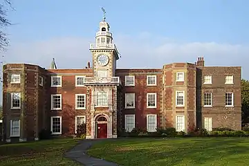
| Bruce Castle | Tottenham, Haringey | House | c. 1600 | 22 July 1949 | TQ3339690676 51°35′57″N 0°04′31″W |
1358861 | |
| Cromwell House | Highgate, Haringey | House | 1637–1638 | 19 March 1951 | TQ2879787290 51°34′11″N 0°08′35″W |
1079233 | 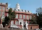 Cromwell House |
| Forecourt Walls to Cromwell House | Highgate, Haringey | Gate Pier | Later | 10 May 1974 | TQ2879087282 51°34′11″N 0°08′35″W |
1188817 | Forecourt Walls to Cromwell House |
| Highpoint I (A–D, G–I, K, 1–12, 12A, and 14– 48) | Highgate, Haringey | Flats | 1933–1935 | 10 May 1974 | TQ2825287841 51°34′29″N 0°09′02″W |
1358885 | 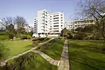 Highpoint I (A–D, G–I, K, 1–12, 12A, and 14– 48) |
| Highpoint II | Highgate, Haringey | Flats | 1936–1938 | 10 May 1974 | TQ2826987801 51°34′28″N 0°09′02″W |
1079183 | 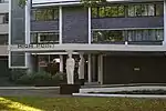 Highpoint II |
| Tower to South West of Bruce Castle | Tottenham, Haringey | Tower | 16th century | 22 July 1949 | TQ3337990652 51°35′56″N 0°04′32″W |
1294388 | 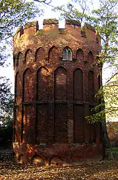 Tower to South West of Bruce Castle |
Grade II*
| Name | Location | Type | Completed [note 1] | Date designated | Grid ref.[note 2] Geo-coordinates |
Entry number [note 3] | Image |
|---|---|---|---|---|---|---|---|
| All Hallows Vicarage, the Priory | Tottenham, Haringey | House | 1620 | 22 July 1949 | TQ3330890796 51°36′01″N 0°04′36″W |
1079263 | 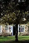 All Hallows Vicarage, the Priory |
| Byron House | Highgate, Haringey | House | Early 18th century | 19 March 1951 | TQ2827187543 51°34′20″N 0°09′02″W |
1358887 | 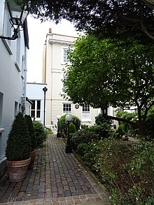 Byron House |
| Church of St Bartholomew | Stamford Hill, Haringey | Parish Church | 1904 | 10 May 1974 | TQ3386688160 51°34′35″N 0°04′11″W |
1079264 | 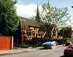 Church of St Bartholomew |
| Church of St John the Baptist (greek Orthodox) | Harringay, Haringey | Parish Church | 1896–1898 | 10 May 1974 | TQ3119889208 51°35′11″N 0°06′28″W |
1189472 | 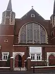 Church of St John the Baptist (greek Orthodox) |
| Dial House | Tottenham, Haringey | House | Late 17th century | 22 July 1949 | TQ3390091350 51°36′18″N 0°04′04″W |
1079241 |  |
| Forecourt Walls and Railings to Number 796 (Percy House) | Tottenham, Haringey | Gate | LATE 17th century OR EARLY 18th century | 22 July 1949 | TQ3389291382 51°36′19″N 0°04′05″W |
1079243 | |
| Front Wall and Gates to the Priory | Tottenham, Haringey | Gate | Early 18th century | 10 May 1974 | TQ3333390788 51°36′01″N 0°04′35″W |
1358844 | 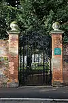 Front Wall and Gates to the Priory |
| Hornsey Town Hall | Crouch End, Haringey | Town Hall | 1935 | 16 January 1981 | TQ3020488316 51°34′43″N 0°07′20″W |
1263688 | 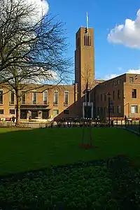 Hornsey Town Hall |
| Ireton House | Highgate, Haringey | House | 18th century | 19 March 1951 | TQ2878487300 51°34′12″N 0°08′36″W |
1079235 | 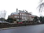 Ireton House |
| Ivy House and Northgate House | Highgate, Haringey | House | Post-1664 | 19 March 1951 | TQ2863987356 51°34′13″N 0°08′43″W |
1358831 | 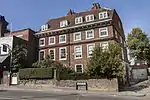 Ivy House and Northgate House |
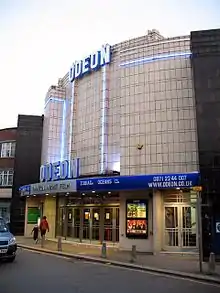
| Odeon Cinema | Muswell Hill, Haringey | Cinema | 1935–1936 | 6 March 1984 | TQ2850889490 51°35′23″N 0°08′47″W |
1079178 | |
| Parish Church of All Hallows | Tottenham, Haringey | Parish Church | 14th century | 22 July 1949 | TQ3331590854 51°36′03″N 0°04′35″W |
1188633 | 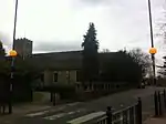 Parish Church of All Hallows |
| Parish Church of St Ann | St Ann's, Haringey | Parish Church | 1861 | 10 May 1974 | TQ3282488674 51°34′53″N 0°05′04″W |
1358852 | 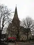 Parish Church of St Ann |
| Percy House | Tottenham, Haringey | House | Mid 18th century | 22 July 1949 | TQ3390491385 51°36′19″N 0°04′04″W |
1079242 | |
| The Queens Public House | Crouch End, Haringey | Hotel | 1899–1901 | 23 November 1973 | TQ3022888571 51°34′51″N 0°07′19″W |
1079170 | 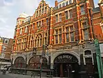 The Queens Public House |
| The Salisbury Public House | Harringay, Haringey | Restaurant | 1898–1899 | 10 May 1974 | TQ3178888753 51°34′56″N 0°05′58″W |
1358865 | 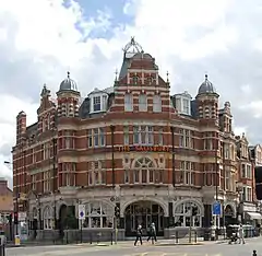 The Salisbury Public House |
| The Sycamores | Highgate, Haringey | House | Early 18th century | 19 March 1951 | TQ2828387560 51°34′20″N 0°09′01″W |
1079194 | 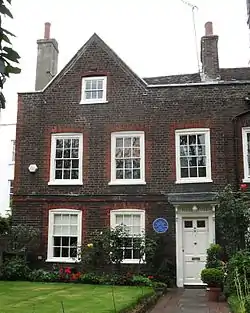 The Sycamores |
| Top Rank Club | Wood Green, Haringey | Bingo Hall | 1933–34 | 26 March 1990 | TQ3100090285 51°35′46″N 0°06′36″W |
1263635 | |
| Tower of Old Parish Church of St Mary | Hornsey, Haringey | Tower | 15th century | 19 March 1951 | TQ3063189290 51°35′14″N 0°06′57″W |
1189047 | 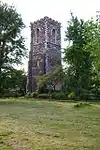 Tower of Old Parish Church of St Mary |
| No. 583 and 585 High Road | Tottenham, Haringey | House | Early to mid-18th century | 22 July 1949 | TQ3384590376 51°35′47″N 0°04′09″W |
1358855 | |
| No. 808 and 810 High Road | Tottenham, Haringey | House | Early 18th century | 22 July 1949 | TQ3390291452 51°36′22″N 0°04′04″W |
1358835 | |
Notes
- The date given is the date used by Historic England as significant for the initial building or that of an important part in the structure's description.
- Sometimes known as OSGB36, the grid reference is based on the British national grid reference system used by the Ordnance Survey.
- The "List Entry Number" is a unique number assigned to each listed building and scheduled monument by Historic England.
External links
 Media related to Grade I listed buildings in the London Borough of Haringey at Wikimedia Commons
- Media related to Grade II* listed buildings in the London Borough of Haringey at Wikimedia Commons
This article is issued from Wikipedia. The text is licensed under Creative Commons - Attribution - Sharealike. Additional terms may apply for the media files.