Grade I and II* listed buildings in the Royal Borough of Greenwich
There are over 9,000 Grade I listed buildings and 20,000 Grade II* listed buildings in England. This page is a list of these buildings in the Royal Borough of Greenwich.
Grade I
| Name | Location | Type | Completed [note 1] | Date designated | Grid ref.[note 2] Geo-coordinates |
Entry number [note 3] | Image |
|---|---|---|---|---|---|---|---|
| Charlton House | Charlton | Community Centre | At present | 19 October 1951 | TQ4155977692 51°28′50″N 0°02′14″E |
1218593 | |
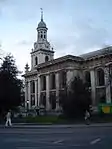
| Church of St Alfege | Greenwich | Church | 1711–14 | 19 October 1951 | TQ3830677605 51°28′50″N 0°00′35″W |
1358970 | |
| Eltham Lodge | Eltham | Steps | 1663–65 | 8 June 1973 | TQ4293473831 51°26′44″N 0°03′19″E |
1358953 |  |
| Garden House to North West of Charlton House | Charlton | Garden House | Mid-late 17th century | 19 October 1951 | TQ4148477773 51°28′52″N 0°02′10″E |
1291892 | 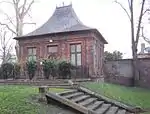 Garden House to North West of Charlton House |
| Gate Lodges at East Gate of Royal Naval College | Greenwich | Lodge | 8 June 1973 | TQ3869377970 51°29′01″N 0°00′14″W |
1358993 | Gate Lodges at East Gate of Royal Naval College | |
| Gateway at Axis to West of Charlton House | Charlton | Gate | Late 17th century | 19 October 1951 | TQ4148877701 51°28′50″N 0°02′10″E |
1358935 | 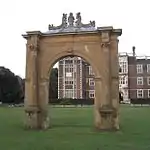 Gateway at Axis to West of Charlton House |
| Great Hall of Eltham Palace | Eltham | Great Hall | c. 1479 | 8 June 1973 | TQ4241173987 51°26′49″N 0°02′53″E |
1079041 | 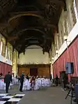 Great Hall of Eltham Palace |
| Morden College | Greenwich | Sundial | 1695 | 19 October 1951 | TQ4036776436 51°28′10″N 0°01′10″E |
1289879 | |
| National Maritime Museum | Greenwich | House | 1616–1637 | 8 June 1973 | TQ3871177697 51°28′52″N 0°00′14″W |
1211481 | |
| North Boundary Wall, Entrance Gateway and Spur Wall with Gateway in Grounds to North of House Called the Tilt Yard | Eltham | Gate | Early 16th century | 8 June 1973 | TQ4261174106 51°26′53″N 0°03′03″E |
1211999 |  North Boundary Wall, Entrance Gateway and Spur Wall with Gateway in Grounds to North of House Called the Tilt Yard |
| North Bridge Across Eltham Palace Moat | Eltham | Bridge | Late 15th century | 8 June 1973 | TQ4246174050 51°26′51″N 0°02′55″E |
1218925 | 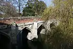 North Bridge Across Eltham Palace Moat |
| Numbers 1 to 14 (consecutive): the Paragon, and Paragon Cottage and Paragon Lodge | Blackheath | Apartment | Since the war | 19 October 1951 | TQ3996676408 51°28′10″N 0°00′49″E |
1211997 | 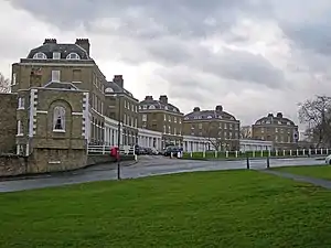 Numbers 1 to 14 (consecutive): the Paragon, and Paragon Cottage and Paragon Lodge |
| Remains of South Bridge Across Eltham Palace Moat | Eltham | Bridge | 16th century | 8 June 1973 | TQ4240673939 51°26′48″N 0°02′52″E |
1358958 | 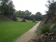 Remains of South Bridge Across Eltham Palace Moat |
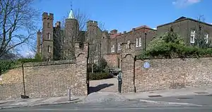
| Royal Arsenal, Royal Brass Foundry | Woolwich | Workshop | 1716–1717 | 8 June 1973 | TQ4373779063 51°29′32″N 0°04′09″E |
1078956 | 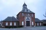 Royal Arsenal, Royal Brass Foundry |
| Royal Naval College, Gates, Gate Piers and Lodges to West Entrance | Greenwich | Gate | 8 June 1973 | TQ3836677798 51°28′56″N 0°00′32″W |
1078973 | 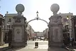 Royal Naval College, Gates, Gate Piers and Lodges to West Entrance | |
| Royal Naval College, North East Building: Queen Anne's Quarter | Greenwich | Naval College | 1699 | 8 June 1973 | TQ3862878007 51°29′03″N 0°00′18″W |
1290044 | 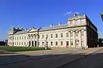 Royal Naval College, North East Building: Queen Anne's Quarter |
| Royal Naval College, North West Building: King Charles Quarters | Greenwich | Pavilion | 1712 | 8 June 1973 | TQ3848877924 51°29′00″N 0°00′25″W |
1211337 | Royal Naval College, North West Building: King Charles Quarters |
| Royal Naval College, Queen Mary's Quarter | Greenwich | Colonnade | 1699 | 8 June 1973 | TQ3867777909 51°28′59″N 0°00′15″W |
1211384 | 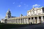 Royal Naval College, Queen Mary's Quarter |
| Royal Naval College, South West Building King William's Quarter | Greenwich | Colonnade | 1703 | 8 June 1973 | TQ3858977860 51°28′58″N 0°00′20″W |
1211426 | 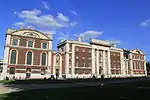 Royal Naval College, South West Building King William's Quarter |
| Royal Observatory, Flamsteed House | Greenwich Park, Greenwich | Pavilion | 18th century | 8 June 1973 | TQ3884777335 51°28′41″N 0°00′07″W |
1358976 | 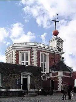 Royal Observatory, Flamsteed House |
| Royal Observatory, Former Great Equatorial Building | Greenwich Park, Greenwich | Observatory | Mid 19th century | 8 June 1973 | TQ3890677312 51°28′40″N 0°00′04″W |
1078998 | 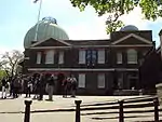 Royal Observatory, Former Great Equatorial Building |
| Royal Observatory, the Transit House | Greenwich Park, Greenwich | House | 17th century | 8 June 1973 | TQ3888877321 51°28′40″N 0°00′05″W |
1220877 | Royal Observatory, the Transit House |
| Royal Observatory, Wall and Clock to Right of Entrance Gates | Greenwich Park, Greenwich | Wall | 8 June 1973 | TQ3888577339 51°28′41″N 0°00′05″W |
1220888 | 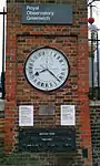 Royal Observatory, Wall and Clock to Right of Entrance Gates | |
| Stable Buildings to South West of Charlton House | Charlton | Stable | 17th century | 19 October 1951 | TQ4155677635 51°28′48″N 0°02′14″E |
1079066 | 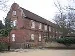 Stable Buildings to South West of Charlton House |
| The Cutty Sark | Greenwich | Museum | By 1973 | 8 June 1973 | TQ3830577866 51°28′58″N 0°00′35″W |
1079013 | 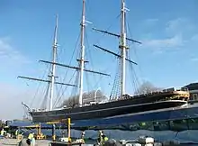 The Cutty Sark |
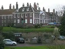
| The Ranger's House | Greenwich | House | c. 1690 | 19 October 1951 | TQ3888776832 51°28′24″N 0°00′06″W |
1218679 |  The Ranger's House |
| Vanbrugh Castle | Maze Hill, Greenwich | House | 1717 | 19 October 1951 | TQ3930877620 51°28′49″N 0°00′17″E |
1078943 | |
| Walls of Inner Courtyard to Eltham Palace, with Chambers Adjoining | Eltham | Bishops Palace | c. 1300 | 8 June 1973 | TQ4242874058 51°26′51″N 0°02′54″E |
1218900 |  Walls of Inner Courtyard to Eltham Palace, with Chambers Adjoining |
.JPG.webp)
Grade II*
| Name | Location | Type | Completed [note 1] | Date designated | Grid ref.[note 2] Geo-coordinates |
Entry number [note 3] | Image |
|---|---|---|---|---|---|---|---|
| Charnel House to Church of St Nicholas | Greenwich | Charnel House | 1697 | 19 October 1951 | TQ3739777722 51°28′54″N 0°01′22″W |
1289734 |  Charnel House to Church of St Nicholas |
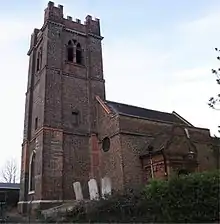
| Church of St Luke | Charlton | Church | Earlier church | 19 October 1951 | TQ4145777835 51°28′54″N 0°02′09″E |
1358934 | |
| Church of St Mary Magdalene | Woolwich | Church | 1727–39 | 26 March 1954 | TQ4306879124 51°29′35″N 0°03′34″E |
1358969 | |
| Church of St Michael and All Angels | Blackheath | Church | 1828–1830 | 8 June 1973 | TQ3996975896 51°27′53″N 0°00′49″E |
1079055 | 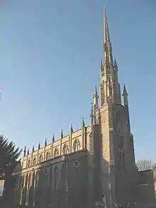 Church of St Michael and All Angels |
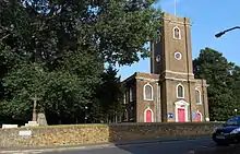
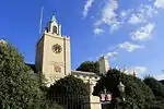
| Church of St Nicholas | Greenwich | Church | 13th century | 19 October 1951 | TQ3739677745 51°28′55″N 0°01′22″W |
1358943 | 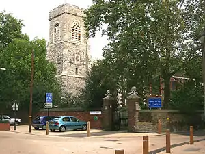 Church of St Nicholas |
| Church of St Nicholas (Plumstead) | Plumstead | Church | Medieval | 26 March 1954 | TQ4593178545 51°29′13″N 0°06′02″E |
1211745 | 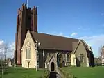 Church of St Nicholas (Plumstead) |
| Cliefden House | Eltham | House | Early 18th century | 26 March 1954 | TQ4282374437 51°27′03″N 0°03′15″E |
1358945 |  Cliefden House |
| Eltham Court (Eltham Palace) | Eltham | Royal Palace | Medieval | 6 July 1981 | TQ4245874010 51°26′50″N 0°02′55″E |
1212906 | 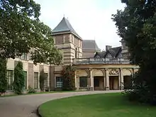 Eltham Court (Eltham Palace) |
| Garden Wall to South of Moat of Well Hall Art Gallery | Eltham | Garden Wall | 26 March 1954 | TQ4244475071 51°27′24″N 0°02′56″E |
1212111 |  Garden Wall to South of Moat of Well Hall Art Gallery | |
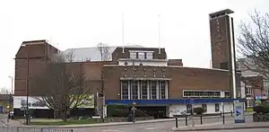
| Granada Cinema | Woolwich | Cinema | 1936–37 | 31 December 1973 | TQ4323679160 51°29′36″N 0°03′43″E |
1212651 | |
| Main Building, Royal Military Academy | Woolwich | Barracks | 1805–08 | 8 June 1973 | TQ4307877208 51°28′33″N 0°03′32″E |
1358936 | Main Building, Royal Military Academy |
| Manna Mead | Greenwich | House | c. 1800 | 19 October 1951 | TQ3844176812 51°28′24″N 0°00′29″W |
1212237 | 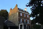 Manna Mead |
| Moat and Bridge to South of Well Hall Art Gallery | Eltham | Moat | 16th century | 26 March 1954 | TQ4243975110 51°27′25″N 0°02′56″E |
1212110 | 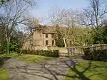 Moat and Bridge to South of Well Hall Art Gallery |
| North and East Walls to Churchyard of St Nicholas and Gate Piers on West Wall | Greenwich | Gate Pier | 1697 | 8 June 1973 | TQ3740077772 51°28′56″N 0°01′22″W |
1219793 | 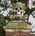 North and East Walls to Churchyard of St Nicholas and Gate Piers on West Wall |
| North Boundary Wall of No. 20 Court Road | Eltham | Boundary Wall | Early 16th century | 8 June 1973 | TQ4265174110 51°26′53″N 0°03′05″E |
1291771 | North Boundary Wall of No. 20 Court Road |
| No. 32 and 32A Court Yard | Eltham | Building | Late 16th century | 8 June 1973 | TQ4248474112 51°26′53″N 0°02′56″E |
1079040 | |
| No. 47 and 49 Maze Hill | Greenwich | House | Early 18th century | 5 April 1954 | TQ3916377773 51°28′54″N 0°00′10″E |
1078940 | 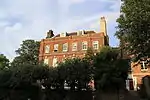 No. 47 and 49 Maze Hill |
| No. 20 Blackheath Park | Blackheath | Detached House | 1957-8 | 29 March 1988 | TQ3998875844 51°27′51″N 0°00′50″E |
1213442 | |
| No. 34, 36 and 38 Court Yard | Eltham | Timber Framed Building | 16th century | 8 June 1973 | TQ4247574106 51°26′53″N 0°02′56″E |
1218878 | |
| No. 6, 8, 10 and 12 Including Forecourt Piers in Front and Walls | Greenwich | Terrace | Early 18th century | 19 October 1951 | TQ3841977454 51°28′45″N 0°00′29″W |
1218993 | 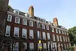 No. 6, 8, 10 and 12 Including Forecourt Piers in Front and Walls |
| No. 85-91 Genesta Road and Attached Walls Gates and Gatepiers | Woolwich | Garage | 1933 | 12 October 1978 | TQ4418277570 51°28′43″N 0°04′29″E |
1247069 | 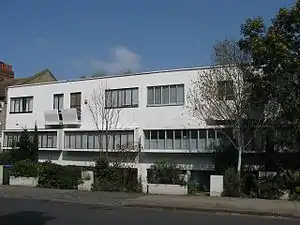 No. 85-91 Genesta Road and Attached Walls Gates and Gatepiers |
| Old brick wall between gardens in front of No. 34 and 36 Court Yard and along road frontage of these houses | Eltham | Wall | 16th century | 8 June 1973 | TQ4248174090 51°26′52″N 0°02′56″E |
1358957 | |
| Orangery to former Eltham House, now at north end of grounds of No. 113 Eltham High Street | Eltham | Orangery | Late 17th century | 26 March 1954 | TQ4284074575 51°27′08″N 0°03′16″E |
1079017 | |
| Outer Courtyard Walls to West and South of Vanbrugh Castle | Maze Hill, Greenwich | Gate Pier | Early 18th century | 8 June 1973 | TQ3930977582 51°28′48″N 0°00′17″E |
1078944 | 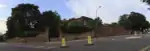 Outer Courtyard Walls to West and South of Vanbrugh Castle |
| Paragon House | Blackheath | House | Late 18th century | 19 October 1951 | TQ3990676436 51°28′11″N 0°00′46″E |
1289733 | .jpg.webp) Paragon House |
| Point House | Greenwich | House | 1701 | 8 June 1973 | TQ3841976821 51°28′24″N 0°00′30″W |
1289615 | 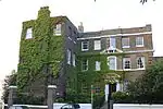 Point House |
| Royal Arsenal, Dial Square Entrance Range | Woolwich | Gate | 1717–1720 | 8 June 1973 | TQ4379479093 51°29′33″N 0°04′12″E |
1211005 | 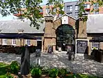 Royal Arsenal, Dial Square Entrance Range |
| Royal Arsenal, Board Room (Old Royal Military Academy) | Woolwich | Pattern Shop | After 1806 | 8 June 1973 | TQ4371279266 51°29′39″N 0°04′08″E |
1359015 | 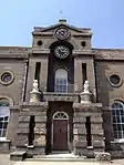 Royal Arsenal, Board Room (Old Royal Military Academy) |
| Royal Arsenal, the Grand Store (West and South Ranges: Buildings 36 37 and 46; E Range: building 49) | Woolwich | Arsenal | 1808–1813 | 8 June 1973 | TQ4404979312 51°29′40″N 0°04′25″E |
1078958 | 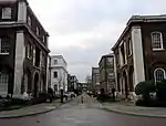 Royal Arsenal, the Grand Store (West and South Ranges: Buildings 36 37 and 46; E Range: building 49) |
| Royal Artillery Barracks, Main Building | Woolwich | Barracks | 1775–1782 | 8 June 1973 | TQ4310478322 51°29′09″N 0°03′35″E |
1078918 | Royal Artillery Barracks, Main Building |
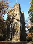
| Severndroog Castle | Castle Wood Park, Shooter's Hill | House | 1784 | 26 March 1954 | TQ4319076196 51°28′00″N 0°03′36″E |
1289792 | |
| Stretch of Old Wall Running East from South East Angle of Gate House Garden | Eltham | Wall | 16th century | 8 June 1973 | TQ4260773996 51°26′49″N 0°03′03″E |
1218860 | |
| The Borough Hall and Meridian House | Greenwich | 1939 | 13 November 1990 | TQ 38235 77334 | 1213855 | ||
| The Manor House | Eltham | House | 1695 | 19 October 1951 | TQ3864877075 51°28′32″N 0°00′18″W |
1358942 | 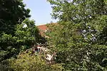 The Manor House |
| The Presbytery | Greenwich | Priests House | c. 1630 | 19 October 1951 | TQ3857477170 51°28′35″N 0°00′22″W |
1079011 | 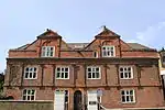 The Presbytery |
| The Rotunda | Woolwich | Garden Building | 1814 | 8 June 1973 | TQ4265078139 51°29′03″N 0°03′11″E |
1078987 | |
| The Standard Reservoir Conduit House | Greenwich Park, Greenwich | Conduit House | Late 17th century or early 18th century | 25 September 2009 | TQ3863277246 51°28′38″N 0°00′19″W |
1393455 | 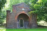 The Standard Reservoir Conduit House |
| The Woodlands | Westcombe Park | House | 1772 | 19 October 1951 | TQ4011277556 51°28′47″N 0°00′59″E |
1078946 | |
| Trinity Hospital | Greenwich | Courtyard | 1613–17 | 19 October 1951 | TQ3882978150 51°29′07″N 0°00′07″W |
1078961 | |
| Wall along frontage of No. 32 and 32a Court Yard, and along north boundary of garden from front to rear | Eltham | Wall | 16th century | 8 June 1973 | TQ4249474139 51°26′54″N 0°02′57″E |
1079039 | |
| Wall running 187 yards along west side of road from north east corner of No. 1 Court Yard to north east corner of Bramber House | Eltham | Wall | 16th century | 8 June 1973 | TQ4261774231 51°26′57″N 0°03′04″E |
1358956 | |
| Walls Surrounding Garden of the Gate House | Eltham | Gate Pier | Late 17th century | 8 June 1973 | TQ4251974077 51°26′52″N 0°02′58″E |
1079038 | |
| Walls to North of Front Garden of Bramber House and Along Road Front | Eltham | Wall | 16th century | 8 June 1973 | TQ4252974111 51°26′53″N 0°02′59″E |
1291744 | |
| Well Hall Art Gallery | Eltham | Restaurant | 1936 | 26 March 1954 | TQ4245675107 51°27′25″N 0°02′56″E |
1289673 | |
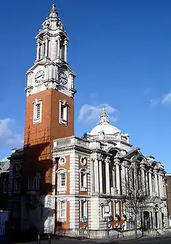
| Woolwich Town Hall | Woolwich | Town Hall | Built 1902–06 | 8 June 1973 | TQ4345278739 51°29′22″N 0°03′53″E |
1289668 |

.jpg.webp)
Notes
- The date given is the date used by Historic England as significant for the initial building or that of an important part in the structure's description.
- Sometimes known as OSGB36, the grid reference is based on the British national grid reference system used by the Ordnance Survey.
- The "List Entry Number" is a unique number assigned to each listed building and scheduled monument by Historic England.
External links
 Media related to Grade I listed buildings in the Royal Borough of Greenwich at Wikimedia Commons
- Media related to Grade II* listed buildings in the Royal Borough of Greenwich at Wikimedia Commons
This article is issued from Wikipedia. The text is licensed under Creative Commons - Attribution - Sharealike. Additional terms may apply for the media files.