Grade I listed buildings in Wrexham County Borough
In the United Kingdom, the term listed building refers to a building or other structure officially designated as being of special architectural, historical, or cultural significance; Grade I structures are those considered to be "buildings of exceptional interest".[1] Listing was begun by a provision in the Town and Country Planning Act 1947. Once listed, strict limitations are imposed on the modifications allowed to a building's structure or fittings. In Wales,[2] the authority for listing under the Planning (Listed Buildings and Conservation Areas) Act 1990[3] rests with Cadw.
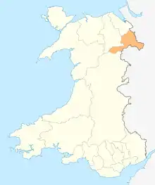
Wrexham County Borough shown within Wales
Buildings
| Name | Location | Date Listed | Grid Ref.[note 1] Geo-coordinates |
Function | Notes | Reference Number | Image |
|---|---|---|---|---|---|---|---|
| Chirk Castle | Chirk | 20 October 1952 | SJ2684838099 52°56′07″N 3°05′23″W |
Castle | The castle stands on a bluff overlooking and controlling the Ceiliog Valley. It is reached by Station Avenue running directly W from Chirk township.[4][5] | 598 | 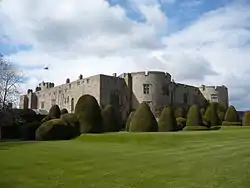 |
| Church of St Mary | Chirk | 4 January 1966 | SJ2914137636 52°55′53″N 3°03′20″W |
Church | The parish church stands at the S end of the main street of Chirk, within its own graveyard, on the N edge of the valley of the Afon Ceiriog.[6][7] | 615 |  |
| Chirk Castle Gates, Screen and Piers | Chirk | 4 January 1966 | SJ2810437681 52°55′54″N 3°04′16″W |
Gates | The screen stands on the skyline at the Llwyn-y-Cil entrance to Chirk Castle Park at the end of Station Avenue, and set back from the right-angled bend.[8][9] | 1315 | 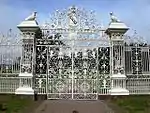 |
| Erddig | Marchwiel | 9 June 1952 | SJ3259248249 53°01′38″N 3°00′23″W |
House | Situated c.3km W of Marchwiel, reached from a series of by-roads running E from the A483. Set within an extremely fine landscaped park of C17 and C18 character.[10][11] | 1533 | .jpg.webp) |
| All Saints' Church, Gresford | Gresford | 7 June 1963 | SJ3464754980 53°05′17″N 2°58′38″W |
Church | Set in rectangular churchyard at the centre of the village.[12][13] | 1591 | 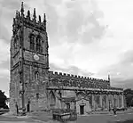 |
| St Chad's Church, Holt | Holt | 7 June 1963 | SJ4120854104 53°04′51″N 2°52′45″W |
Church | Set within a rectangular churchyard, at the end of a lane, and retaining good C19 monuments.[14][15] | 1596 | 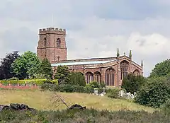 |
| Pontcysyllte Aqueduct | Llangollen Rural | 7 June 1963 | SJ2704241984 52°58′13″N 3°05′16″W |
Aqueduct | Located over the River Dee between Trevor and Froncysyllte.[16][17] | 1601 | 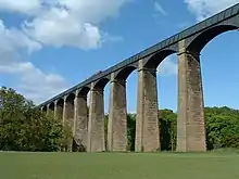 |
| Pont Cysylltau | Llangollen Rural | 7 June 1963 | SJ2680842043 52°58′15″N 3°05′29″W |
Bridge | Situated near a looping bend in River Dee between Trevor and Froncysyllte.[18][19] | 1602 |  |
| Church of St Mary, including churchyard walls and lychgate | Ruabon | 7 June 1963 | SJ3027643801 52°59′13″N 3°02′24″W |
Church | Situated in the church yard which is between Bridge Street and Church Street.[20][21] | 1622 | 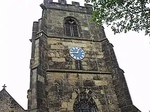 |
| Bangor Bridge (partly in Bangor-is-y-Coed Community) | Sesswick | 16 November 1962 | SJ3881045454 53°00′10″N 2°54′48″W |
Bridge | The corresponding number for the part of the bridge in the Bangor-is-y-Coed community is 1645.[22][23] | 1635 | 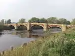 |
| Halghton Hall | Halghton, Hanmer | 17 March 1953 | SJ4156642431 52°58′34″N 2°52′18″W |
Country House | Reached by a minor road and farm road on the S side of the A525, 4km SE of Bangor-is-y-coed.[24][25] | 1641 |  |
| Bangor Bridge | Bangor is y Coed | 16 November 1962 | SJ3878545440 53°00′10″N 2°54′49″W |
Bridge | Situated at the end of the High Street crossing the River Dee.[26][27] | 1645 | |
| Parish Church of St Deiniol | Willington Worthenbury | 16 November 1962 | SJ4189346228 53°00′37″N 2°52′03″W |
Parish Church | Located to the west of the centre of the village, a short distance along Church Road, within a walled graveyard. Fine views of the church across open meadows on the approach to the village from the south on the B5069.[28][29] | 1705 | 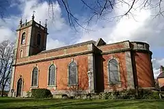 |
| Holt Bridge | Holt | 7 June 1963 | SJ4115854391 53°05′01″N 2°52′48″W |
Bridge | Spanning the broad River Dee which forms the boundary between Wales and England. Carries the main road, formerly the A 534, between Holt and Farndon.[30][31] | 1742 | 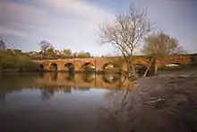 |
| St Giles' Church, Wrexham | Offa | 30 May 1951 | SJ3355350121 53°02′39″N 2°59′33″W |
Church | In enclosed churchyard, standing at southern boundary of town centre to rear of High Street, prominently sited above and valley of the River Gwenfro.[32][33] | 1769 |  |
| Newbridge Lodge | Cefn | 30 April 1996 | SJ2871941834 52°58′09″N 3°03′46″W |
Lodge | South-western entrance to the Park, on the W bank of the Dee immediately NW of New Bridge over the river.[34][35] | 16872 |  |
| Entrance Gates and Railings at Newbridge Lodge | Cefn | 30 April 1996 | SJ2872341824 52°58′09″N 3°03′46″W |
Gates | South-western entrance to the Park, on the W bank of the Dee immediately NW of New Bridge over the river.[36][37] | 16873 |  |
Notes
- Sometimes known as OSGB36, the grid reference is based on the British national grid reference system used by the Ordnance Survey.
References
- "Buildings & Conservation Areas". Cadw. Retrieved 18 June 2013.
- "Coflein". online database of RCAHMW. Royal Commission on the Ancient and Historical Monuments of Wales. Retrieved 28 November 2016.
- "Planning (Listed Buildings and Conservation Areas) Act 1990". The National Archives. Retrieved 18 June 2013.
- Cadw. "Chirk Castle (598)". National Historic Assets of Wales. Retrieved 7 April 2019.
- "Chirk Castle". British Listed Buildings. Retrieved 7 April 2019.
- Cadw. "Church of St Mary (615)". National Historic Assets of Wales. Retrieved 7 April 2019.
- "Church of St Mary". British Listed Buildings. Retrieved 7 April 2019.
- Cadw. "Chirk Castle Gates, Screen and Piers (1315)". National Historic Assets of Wales. Retrieved 7 April 2019.
- "Chirk Castle Gates, Screen and Piers". British Listed Buildings. Retrieved 7 April 2019.
- Cadw. "Erddig (1533)". National Historic Assets of Wales. Retrieved 7 April 2019.
- "Erddig". British Listed Buildings. Retrieved 7 April 2019.
- Cadw. "Parish Church of All Saints (1591)". National Historic Assets of Wales. Retrieved 7 April 2019.
- "Parish Church of All Saints". British Listed Buildings. Retrieved 7 April 2019.
- Cadw. "Parish Church of St Chad (1596)". National Historic Assets of Wales. Retrieved 7 April 2019.
- "Parish Church of St Chad". British Listed Buildings. Retrieved 7 April 2019.
- Cadw. "Pontcysyllte Aqueduct (1601)". National Historic Assets of Wales. Retrieved 7 April 2019.
- "Pontcysyllte Aqueduct". British Listed Buildings. Retrieved 7 April 2019.
- Cadw. "Pont Cysylltau (1602)". National Historic Assets of Wales. Retrieved 7 April 2019.
- "Pont Cysylltau". British Listed Buildings. Retrieved 7 April 2019.
- Cadw. "Church of St Mary, including churchyard walls and lych gate (1622)". National Historic Assets of Wales. Retrieved 7 April 2019.
- "Church of St Mary, including churchyard walls and lych gate". British Listed Buildings. Retrieved 7 April 2019.
- Cadw. "Bangor Bridge (Partly in Bangor-is-y-Coed Community) (1635)". National Historic Assets of Wales. Retrieved 7 April 2019.
- "Bangor Bridge (Partly in Bangor-is-y-Coed Community)". British Listed Buildings. Retrieved 7 April 2019.
- Cadw. "Halghton Hall (1641)". National Historic Assets of Wales. Retrieved 7 April 2019.
- "Halghton Hall". British Listed Buildings. Retrieved 7 April 2019.
- Cadw. "Bangor Bridge (Partly in the Sesswick community) (1645)". National Historic Assets of Wales. Retrieved 7 April 2019.
- "Bangor Bridge (Partly in the Sesswick community)". British Listed Buildings. Retrieved 7 April 2019.
- Cadw. "Parish Church of St Deiniol (1705)". National Historic Assets of Wales. Retrieved 7 April 2019.
- "Parish Church of St Deiniol". British Listed Buildings. Retrieved 7 April 2019.
- Cadw. "Holt Bridge (1742)". National Historic Assets of Wales. Retrieved 7 April 2019.
- "Holt Bridge". British Listed Buildings. Retrieved 7 April 2019.
- Cadw. "Parish Church of St Giles (1769)". National Historic Assets of Wales. Retrieved 7 April 2019.
- "Parish Church of St Giles". British Listed Buildings. Retrieved 7 April 2019.
- Cadw. "Newbridge Lodge (16872)". National Historic Assets of Wales. Retrieved 7 April 2019.
- "Newbridge Lodge". British Listed Buildings. Retrieved 7 April 2019.
- Cadw. "Entrance Gates and Railings at Newbridge Lodge (16873)". National Historic Assets of Wales. Retrieved 7 April 2019.
- "Entrance Gates and Railings at Newbridge Lodge". British Listed Buildings. Retrieved 7 April 2019.
External links
![]() Media related to Grade I listed buildings in Wrexham County Borough at Wikimedia Commons
Media related to Grade I listed buildings in Wrexham County Borough at Wikimedia Commons
| Principal settlements | | |
|---|---|---|
| Communities |
| |
| Other villages and areas |
| |
| Castles | ||
| Buildings and structures | ||
| Rivers | ||
| Geographical features | ||
| Topics | ||
This article is issued from Wikipedia. The text is licensed under Creative Commons - Attribution - Sharealike. Additional terms may apply for the media files.