Grade II* listed buildings in Wrexham County Borough
In the United Kingdom, the term listed building refers to a building or other structure officially designated as being of special architectural, historical, or cultural significance; Grade II* structures are those considered to be "particularly important buildings of more than special interest".[1] Listing was begun by a provision in the Town and Country Planning Act 1947. Once listed, strict limitations are imposed on the modifications allowed to a building's structure or fittings. In Wales, the authority for listing under the Planning (Listed Buildings and Conservation Areas) Act 1990[2] rests with Cadw.
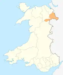
Wrexham County Borough shown within Wales
Buildings
| Name | Location | Date Listed | Grid Ref.[note 1] Geo-coordinates |
Function | Notes | Reference Number | Image |
|---|---|---|---|---|---|---|---|
| Brynkinallt Hall | Chirk | 20 October 1952 | SJ3031237867 52°56′01″N 3°02′18″W |
Hall | The Brynkinallt Estate lies to the E of Chirk town, and straddles the national boundary.[3][4] | 599 |  |
| Dolwen | Ceiriog Ucha | 20 October 1952 | SJ1443633896 52°53′45″N 3°16′24″W |
House | Located off a lane which runs W from the main crossroads in Llanarmon Dyffryn Ceiriog, following the River Ceiriog. The house is in a fine position on the N bank of the river with the hills rising behind. The front faces S.[5][6] | 602 | |
| Chirk Aqueduct (continued into England) | Chirk | 1 April 1966 | SJ2869937277 52°55′41″N 3°03′44″W |
Aqueduct | The aqueduct straddles the Ceiriog Valley, approximately 55m SW of the parish church, and can be reached by a footpath from Castle Road. The aqueduct passes into England (Weston Rhyn) at its S end.[7][8] | 618 | 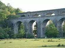 |
| Railway Viaduct over River Dee | Cefn | 1 April 1966 | SJ2852441231 52°57′49″N 3°03′56″W |
Viaduct | Carries the railway over the River Dee between Newbridge and Cefn-Bychan[9][10] | 619 | 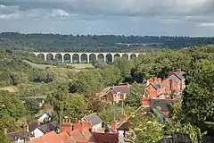 |
| Cefn (Newbridge) Viaduct (partly in Cefn Community) | Chirk | 1 April 1966 | SJ2853641173 52°57′47″N 3°03′55″W |
Viaduct | The viaduct carries the railway across the wide valley of the River Dee between Newbridge and Cefn-bychan.[11][12] | 628 | |
| Queen Anne's Cottage | Chirk | 12 March 1973 | SJ2874639985 52°57′09″N 3°03′43″W |
Cottage | The cottage is located within Whitehurst Gardens, which are accessed directly from the A5 200m N of the roundabout at the N end of Chirk.[13][14] | 1288 | |
| Trevalyn Hall (including former lodge) | Rossett | 6 September 1952 | SJ3649856798 53°06′17″N 2°57′00″W |
Hall | Situated in its own grounds set back, and to the south-east, of the Chester Road (B5102)[15][16] | 1528 | 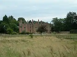 |
| Rossett Mill | Rossett | 6 September 1952 | SJ3646257035 53°06′24″N 2°57′02″W |
Mill | Situated slightly back from the north-west of the B 5102 Chester Road and to the north of the main village of Rossett. Stands in its own grounds with new stable developments to the rear south of the Alyn Bridge.[17][18] | 1530 |  |
| Manley Hall, Erbistock | Erbistock | 6 September 1952 | SJ3498341505 52°58′01″N 2°58′10″W |
Hall | Situated 600m NW of Erbistock reached from a track running SE off the A539.[19] | 1531 | |
| Esclusham Hall | Esclusham | 6 September 1952 | SJ2955748102 53°01′32″N 3°03′06″W |
Hall | Between the B5097 and the B5426 at Talwrn, S of the reservoir associated with the Legacy Waterworks.[20][21] | 1534 | |
| Borras Hall | Holt | 6 July 1963 | SJ3712152590 53°04′01″N 2°56′23″W |
House | Situated 0.5km N off the A534 on the by-road which runs N to Gresford.[22][23] | 1563 | 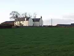 |
| Borras Head | Holt | 6 July 1963 | SJ3670953256 53°04′22″N 2°56′46″W |
House | Situated to the S of Borras Road, just before the turning for the by-road which runs from the A534 to Gresford.[24] | 1565 | |
| Berse vicarage with flanking walls to garden, Berse Drelincourt | Broughton | 6 July 1963 | SJ3160750856 53°03′02″N 3°01′18″W |
Vicarage | Set back from Berse Road down a drive opposite Berse Drelincourt Church.[25][26] | 1567 | |
| Dovecote at Erbistock Hall | Erbistock | 6 July 1963 | SJ3512042438 52°58′31″N 2°58′04″W |
Dovecote | Circular brick dovecote dated 1737.[27][28] | 1578 | |
| The Groves (also known as Grove Farm), Erbistock | Erbistock | 6 July 1963 | SJ3595041999 52°58′17″N 2°57′19″W |
Farmhouse | Situated at the end of a track running E off a by-road which runs S off the A528 to Erbistock.[29][30] | 1580 | |
| Manor Farmhouse, (also known as Eyton Manor Farmhouse), Eyton | Erbistock | 6 July 1963 | SJ3547344440 52°59′36″N 2°57′46″W |
Farmhouse | Situated on the W side of the A528 N of Overton Bridge.[31][32] | 1581 | |
| Stable Courtyard Range | Marchwiel | 6 July 1963 | SJ3260248158 53°01′35″N 3°00′23″W |
Stables | Situated immediately to the S of the kitchen block at Erddig.[33][34] | 1584 | |
| Octagonal Building at Bersham Ironworks Site | Esclusham | 6 July 1963 | SJ3071949234 53°02′09″N 3°02′05″W |
Ironworks | In the centre of Bersham Village, towards the E end of the Ironworks site.[35][36] | 1586 |  |
| Hafod-y-Bwch Hall | Esclusham | 6 July 1963 | SJ3100847863 53°01′25″N 3°01′48″W |
Hall | Between the A483 and the B5605, and approached via a drive from the B5605 immediately W of the roundabout at Croesfoel.[37][38] | 1587 | |
| Esless Hall | Esclusham | 6 July 1963 | SJ3190949259 53°02′11″N 3°01′01″W |
Hall | Set back down a drive on the NE side of the Old Hall Farm estate on the E side of Rhostyllen, and above the River Clywedog.[39][40] | 1590 | |
| Holt Castle | Holt | 6 July 1963 | SJ4113053770 53°04′41″N 2°52′49″W |
Castle | Situated at the end of a path to the S side of Deeside. The castle remains are situated on a sandstone boss around which a quarry was later dug out.[41] | 1595 | 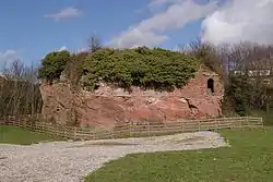 |
| Church of Saints Marcella and Deiniol, Marchwiel | Marchwiel | 6 July 1963 | SJ3572547723 53°01′23″N 2°57′35″W |
Church | Situated in the centre of the village set back from the road in a rectangular churchyard.[42][43] | 1614 |  |
| Wynn Hall | Penycae | 6 July 1963 | SJ2902044808 52°59′45″N 3°03′32″W |
Country house | On the corner of the B5097 Ruabon road and Plas Bennion Road, at the SE end of the village.[44][45] | 1620 | |
| Plas Newydd, Ruabon | Ruabon | 6 July 1963 | SJ2991843866 52°59′15″N 3°02′44″W |
Situated off Pont Adam to the NW of the town centre.[46][47] | 1626 | | |
| Wynnstay Hall | Ruabon | 6 July 1963 | SJ3088542607 52°58′35″N 3°01′51″W |
Country House | Set in an important landscaped park 1.3 km SE of Ruabon and reached by a private drive running S from Broth Lodge on A539.[48][49] | 1627 |  |
| The Bath House, Wynnstay | Ruabon | 6 July 1963 | SJ3053743422 52°59′01″N 3°02′10″W |
Bathhouse | Situated within Wynnstay Park.[50][51] | 1628 | |
| Bettisfield Hall | Maelor South | 17 March 1953 | SJ4623835974 52°55′07″N 2°48′04″W |
Hall | Set back from the main road through Bettisfield, opposite the parish church.[52][53] | 1639 |  |
| The Bryn | Hanmer | 17 March 1953 | SJ4294441012 52°57′48″N 2°51′03″W |
House | Reached by a short farm road on the E side of Bryn Lane, approximately 1.6km W of Horseman's Green hamlet.[54][55] | 1640 | |
| Willington Cross | Willington Worthenbury | 17 March 1953 | SJ4496642783 52°58′46″N 2°49′16″W |
Cross | Located off a lane from the cross-roads at Willington Cross, set in open fields and approached by a private drive.[56][57] | 1642 | 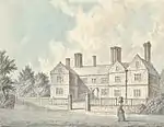 |
| Church of St. Dunawd | Bangor-is-y-Coed | 16 November 1962 | SJ3887645404 53°00′09″N 2°54′44″W |
Church | Situated in a rectangular churchyard set back from High Street.[58][59] | 1644 | 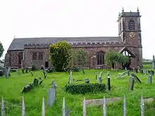 |
| Althrey Hall | Bangor-is-y-Coed | 16 November 1962 | SJ3790644093 52°59′26″N 2°55′35″W |
Hall | Situated c0.8km SW of Bangor Is-y-coed, reached from a drive running W from the B5069.[60][61] | 1647 | |
| The Ashes Farmhouse | Maelor South | 16 November 1962 | SJ4446636981 52°55′39″N 2°49′39″W |
Farmhouse | Reached by farm road on the NE side of a minor road between Breaden Heath and Penley, approximately 1.9km NW of Bettisfield church.[62][63] | 1651 | |
| Bettisfield Park, including attached garden walls | Hanmer | 16 November 1962 | SJ4606637500 52°55′56″N 2°48′14″W |
Country House | A restored 18th century country house.[64][65] | 1652 | |
| Church of St Chad | Hanmer | 16 November 1962 | SJ4546139734 52°57′08″N 2°48′48″W |
Church | In a large churchyard and the most prominent building in the village, W of The Square and N of Hanmer Mere.[66][67] | 1658 | _(St_Chad's_church).jpg.webp) |
| Wern Farmhouse | Hanmer | 16 November 1962 | SJ4442640112 52°57′20″N 2°49′43″W |
Farmhouse | Reached by farm road on the N side of the A539, approximately 1.1km W of Hanmer.[68][69] | 1664 | |
| Iscoyd Park | Bronington | 16 November 1962 | SJ5044941977 52°58′22″N 2°44′22″W |
Hall | In its own grounds on the N side of the A525 at Redbrook, and E of a minor road to Higher Wych.[70][71] | 1670 | .jpg.webp) |
| Maes-y-Groes Farmhouse | Bronington | 16 November 1962 | SJ4981843045 52°58′57″N 2°44′56″W |
Farmhouse | On the W side of a minor road between Higher Wych and Redbrook, approximately 550m S of Higher Wych hamlet.[72][73] | 1677 | |
| Pen-y-bryn | Bronington | 16 November 1962 | SJ4855843616 52°59′15″N 2°46′04″W |
House | Reached by private road on the W side of a minor road and approximately 1.1km W of Higher Wych.[74][75] | 1678 | |
| Church of Saint Mary | Overton | 16 November 1962 | SJ3733241817 52°58′12″N 2°56′05″W |
Church | At right-angles to High Street, in churchyard which runs between High Street and School Lane.[76][77] | 1679 |  |
| Knolton Hall, Knolton | Knolton, Overton-on-Dee | 16 November 1962 | SJ3526040573 52°57′31″N 2°57′55″W |
Hall | A 16th century house which has been successively extended and remodelled.[78][79] | 1691 | |
| Llan-y-Cefn, Knolton | Knolton, Overton-on-Dee | 16 November 1962 | SJ3560141081 52°57′48″N 2°57′37″W |
House | House with panelled interiors of the exceptional interest.[80][81] | 1692 | |
| Horseman's Green Farmhouse | Hanmer | 16 November 1962 | SJ4473541421 52°58′02″N 2°49′28″W |
Farmhouse | On the N side of the hamlet, set back on the W side of a minor road to the A525.[82][83] | 1704 | |
| Miners' Institute | Rhosllanerchrugog | 17 March 1987 | SJ2925246535 53°00′41″N 3°03′21″W |
Institute | An imposing public building above street level, up steps in a railed forecourt.[84][85] | 1721 | 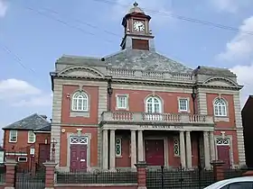 |
| Bryn-y-Grog Hall | Marchwiel | 19 July 1989 | SJ3484448398 53°01′44″N 2°58′23″W |
Hall | Situated c. 1km NW of Marchwiel in open countryside above the main road from Marchwiel to Wrexham.[86][87] | 1727 | |
| Former agent's house at site of Brymbo Ironworks | Brymbo | 25 October 1991 | SJ2947053475 53°04′26″N 3°03′15″W |
House | On the hillside to the S of the old ironworks site at Brymbo, adjacent to the rail line to Brymbo Colliery. Access by track and then steps from the main level of the ironworks.[88][89] | 1731 | 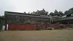 |
| Lower Berse Farmhouse, Berse Lane | Offa, Wrexham | 6 July 1963 | SJ3121950083 53°02′37″N 3°01′39″W |
Farmhouse | Farmhouse, remodelled in 1873 but incorporating the remains of an earlier timber framed hall.[90][91] | 1762 | |
| Tomb of Elihu Yale, west of Church of St. Giles, Church Street | Offa, Wrexham | 16 June 1980 | SJ3352150113 53°02′39″N 2°59′35″W |
Tomb | West of the tower of Saint Giles' church.[92][93] | 1770 | .jpg.webp)
|
| St. Giles' churchyard gates, Church Street | Offa, Wrexham | 30 May 1951 | SJ3353050168 53°02′41″N 2°59′35″W |
Gates | Main entrance gates to churchyard, erected in 1720.[94][95] | 1774 |  |
| Croesnewydd Hall, Rhyd Broughton Lane | Offa, Wrexham | 6 September 1952 | SJ3211150606 53°02′54″N 3°00′51″W |
Hall | In Wrexham Technology Park.[96][97] | 1806 | 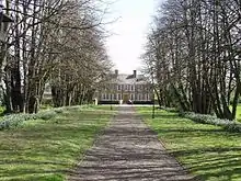 |
| No 7 Town Hill | Offa, Wrexham | 16 June 1980 | SJ3348050188 53°02′41″N 2°59′37″W |
House | Late-medieval timber framed building.[98][99] | 1817 | |
| Penrhos Engine House | Brymbo | 12 January 1995 | SJ2856953225 53°04′17″N 3°04′03″W |
Engine House | On the N side of the road running on the W side of the former Steel Works site, W of Pen-Rhos Farm.[100][101] | 14889 | 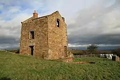 |
| Wynnstay Kennels (including valeting house and attached courtyard buildings and boundary walls), Pen-y | Ruabon | 22 February 1995 | SJ3256042952 52°58′47″N 3°00′21″W |
Kennels | Built in 1843.[102][103] | 15723 | |
| Vertical winding engine house at the former Wynnstay Colliery, Plas Madoc | Ruabon | 22 February 1995 | SJ2937243285 52°58′56″N 3°03′12″W |
Engine House | Built 1855-6 as one of the original structures of the Wynnstay Colliery.[104][105] | 15731 | 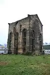 |
| The Dairy at Wynnstay Hall, Wynnstay | Ruabon | 22 February 1995 | SJ3116142635 52°58′36″N 3°01′36″W |
Dairy | Situated 200m E of Wynnstay Hall.[106][107] | 15742 | |
| Wynnstay Column, Wynnstay | Ruabon | 22 February 1995 | SJ3056843065 52°58′50″N 3°02′08″W |
Column | Erected in 1789 in memory of Sir Watkin Williams-Wynn who died in 1788.[108][109] | 15746 | |
| Cascade, Wynnstay | Ruabon | 22 February 1995 | SJ3036443128 52°58′52″N 3°02′19″W |
Cascade | Sited within Wynnstay Park, 230m east of Wynnstay Column.[110][111] | 15749 | |
| No 7, Church Street | Offa, Wrexham | 7 March 1974 | SJ3351350186 53°02′41″N 2°59′35″W |
Wine Bar | Chequers Wine Bar. Situated on west side of Church Street, in a prominent position on approach to the church.[112][113] | 1776 | .jpg.webp) |
| No 8 Church Street | Offa, Wrexham | 7 March 1974 | SJ3351250189 53°02′41″N 2°59′35″W |
Wine Bar | Chequers Wine Bar. Situated on west side of Church Street, in a prominent position on approach to the church.[114] | 16477 | |
| No 9 Church Street | Offa, Wrexham | 7 March 1974 | SJ3351050195 53°02′42″N 2°59′36″W |
Wine Bar | Chequers Wine Bar. Situated on west side of Church Street, in a prominent position on approach to the church.[115][116] | 16478 | |
| No 10 Church Street | Offa, Wrexham | 7 March 1974 | SJ3350850199 53°02′42″N 2°59′36″W |
House | Situated on west side of Church Street, in a prominent position on approach to the church.[117][118] | 16479 | |
| Single Storey Building to SE of Octagonal Building at Bersham Ironworks Site | Bersham, Esclusham | 6 July 1963 | SJ3073349229 53°02′09″N 3°02′04″W |
Ironworks | In the centre of Bersham Village, towards the E end of the Ironworks site.[119][120] | 16539 | |
| Church of Saint Mary | Bersham, Esclusham | 12 August 1995 | SJ3052149281 53°02′11″N 3°02′15″W |
Church | In a wooded churchyard on the W side of Bersham village.[121][122] | 16553 |  |
| Bersham Colliery No 2 Headframe | Bersham, Esclusham | 12 August 1995 | SJ3145948170 53°01′35″N 3°01′24″W |
Colliery headstock | On the SE side of the lane which leaves Wrexham Road opposite Church Street towards the W end of Rhostyllen.[123][124] | 16567 | 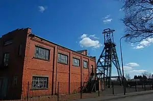 |
| Kitchen and attached laundries, bakehouse and scullery at Erddig | Marchwiel | 6 July 1963 | SJ3260048190 53°01′36″N 3°00′23″W |
Kitchen block | Situated immediately to the S of Erddig and attached to the house by a late C19 linking block.[125][126] | 17850 | |
| Screen and gates closing the formal garden at Erddig | Marchwiel | 12 March 1996 | SJ3288948265 53°01′39″N 3°00′08″W |
Screen and Gates | Situated at the far end of the ornamental canal in the formal garden to the E of Erddig.[127][128] | 17859 | 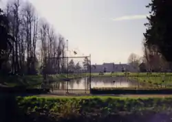 |
| Cup and Saucer | Marchwiel | 12 March 1996 | SJ3245648401 53°01′43″N 3°00′31″W |
Hydraulic system | Situated c0.2m NW of Erddig to the W of the carriage drive.[129][130] | 17869 |  |
| War Memorial | Chirk | 29 July 1998 | SJ2905137755 52°55′57″N 3°03′25″W |
War memorial | The war memorial is set on a traffic island at the junction of Station Avenue with Church Street, near the centre of Chirk[131][132] | 20202 |  |
| Chirk Tunnel, including the N and S portals, and Chirk Basin | Chirk | 29 July 1998 | SJ2864337451 52°55′47″N 3°03′47″W |
Tunnel | The Chirk tunnel continues the canal N from Chirk basin at the N end of the aqueduct, and is reached by a path from Castle Road.[133][134] | 20209 | 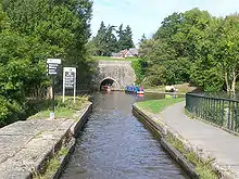 |
| Railway Viaduct over River Ceiriog | Chirk | 29 July 1998 | SJ2866837285 52°55′42″N 3°03′45″W |
Viaduct | The viaduct crosses the valley parallel to Chirk Aqueduct, 550m SW of the Church at the centre of the village.[135][136] | 20210 | 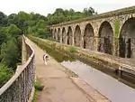 |
| Chirk Castle Stable Ranges | Chirk | 29 July 1998 | SJ2683238038 52°56′05″N 3°05′24″W |
Stables | The stables adjoin the castle to the S, forming two sides of the service courtyard[137][138] | 20248 | |
| Church of St John the Baptist | Maelor South | 17 October 2001 | SJ4613236021 52°55′08″N 2°48′09″W |
Church | In a large churchyard opposite Bettisfield Hall Farm, beyond the N end of the village.[139][140] | 25804 | 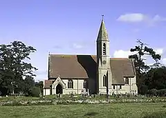 |
| Ceiriog Memorial Institute including retaining wall and railings | Llansantffraid Glyn Ceiriog | 7 August 2003 | SJ2021237848 52°55′56″N 3°11′19″W |
Institute | Located towards the S end of the High Street. The ground rises to the W and the building is slightly raised above road level.[141][142] | 81286 | |
| Fenn's Moss Peat Processing Works | Bronington | 20 October 2005 | SJ4780736656 52°55′29″N 2°46′40″W |
Peat works | An isolated building on the S side of a former railway, approximately 2.2km NE of Bettisfield.[143][144] | 85456 | |
| The Gelli | Bronington | 20 October 2005 | SJ4640943809 52°59′20″N 2°47′59″W |
Country house | Reached by private road on the N side of a minor road between Tallarn Green and Tybroughton, approximately 1.9km ESE of Tallarn Green church.[145][146] | 85502 | 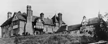 |
| Gates and gate piers at south entrance to Hanmer churchyard | Hanmer | 15 November 2005 | SJ4544239656 52°57′05″N 2°48′49″W |
Gates | On the S side of the churchyard opposite Hanmer Mere.[147][148] | 86936 |  |
| Hanmer churchyard cross | Hanmer | 15 November 2005 | SJ4546539721 52°57′08″N 2°48′47″W |
Cross | On the S side of the nave, and immediately S of the footpath leading from porch to The Square.[149][150] | 86940 |  |
| Hanmer war memorial | Hanmer | 15 November 2005 | SJ4542339661 52°57′06″N 2°48′50″W |
War memorial | Set into the S churchyard wall W of the main entrance and opposite Hanmer Mere.[151][152] | 86941 | 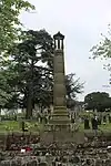 |
| The Stables at Bettisfield Park | Hanmer | 16 November 1962 | SJ4607937592 52°55′59″N 2°48′13″W |
Stables | On the N side of the house and reached by a separate entrance from New Road.[153][154] | 86950 | |
Notes
- Sometimes known as OSGB36, the grid reference is based on the British national grid reference system used by the Ordnance Survey.
References
- "Buildings & Conservation Areas". Cadw. Retrieved 18 June 2013.
- "Planning (Listed Buildings and Conservation Areas) Act 1990". The National Archives. Retrieved 18 June 2013.
- Cadw. "Brynkinallt Hall (599)". National Historic Assets of Wales. Retrieved 10 April 2019.
- "Brynkinallt Hall". British Listed Buildings.
- Cadw. "Dolwen (602)". National Historic Assets of Wales. Retrieved 10 April 2019.
- "Dolwen". British Listed Buildings.
- Cadw. "Chirk Aqueduct (continued into England) (618)". National Historic Assets of Wales. Retrieved 10 April 2019.
- "Chirk Aqueduct (continued into England)". British Listed Buildings.
- Cadw. "Railway Viaduct over River Dee (619)". National Historic Assets of Wales. Retrieved 10 April 2019.
- "Railway Viaduct over River Dee". British Listed Buildings.
- Cadw. "Cefn (Newbridge) Viaduct (partly in Cefn Community) (628)". National Historic Assets of Wales. Retrieved 10 April 2019.
- "Cefn (Newbridge) Viaduct (partly in Cefn Community)". British Listed Buildings.
- Cadw. "Queen Anne's Cottage (1288)". National Historic Assets of Wales. Retrieved 10 April 2019.
- "Queen Anne's Cottage". British Listed Buildings.
- Cadw. "Trevalyn Hall (including former lodge) (1528)". National Historic Assets of Wales. Retrieved 10 April 2019.
- "Trevalyn Hall (including former lodge)". British Listed Buildings.
- Cadw. "Rossett Mill (1530)". National Historic Assets of Wales. Retrieved 10 April 2019.
- "Rossett Mill". British Listed Buildings.
- Cadw. "Manley Hall (1531)". National Historic Assets of Wales. Retrieved 10 April 2019.
- Cadw. "Esclusham Hall (1534)". National Historic Assets of Wales. Retrieved 10 April 2019.
- "Esclusham Hall". British Listed Buildings.
- Cadw. "Borras Hall (1563)". National Historic Assets of Wales. Retrieved 10 April 2019.
- "Borras Hall". British Listed Buildings.
- Cadw. "Borras Head (1565)". National Historic Assets of Wales. Retrieved 10 April 2019.
- Cadw. "Berse Vicarage with Flanking Walls to Garden (1567)". National Historic Assets of Wales. Retrieved 10 April 2019.
- "Berse Vicarage with Flanking Walls to Garden". British Listed Buildings.
- Cadw. "Dovecote at Erbistock Hall (1578)". National Historic Assets of Wales. Retrieved 10 April 2019.
- "Dovecote at Erbistock Hall". British Listed Buildings.
- Cadw. "The Groves (Also Known as Grove Farm) (1580)". National Historic Assets of Wales. Retrieved 10 April 2019.
- "The Groves (Also Known as Grove Farm)". British Listed Buildings.
- Cadw. "Manor Farmhouse (Also Known As Eyton Manor Farmhouse) (1581)". National Historic Assets of Wales. Retrieved 10 April 2019.
- "Manor Farmhouse (Also Known As Eyton Manor Farmhouse)". British Listed Buildings.
- Cadw. "Stable Courtyard Range (1584)". National Historic Assets of Wales. Retrieved 10 April 2019.
- "Stable Courtyard Range". British Listed Buildings.
- Cadw. "Octagonal Building at Bersham Ironworks Site (1586)". National Historic Assets of Wales. Retrieved 10 April 2019.
- "Octagonal Building at Bersham Ironworks Site". British Listed Buildings.
- Cadw. "Hafod-y-Bwch Hall (1587)". National Historic Assets of Wales. Retrieved 10 April 2019.
- "Hafod-y-Bwch Hall". British Listed Buildings.
- Cadw. "Esless Hall (1590)". National Historic Assets of Wales. Retrieved 10 April 2019.
- "Esless Hall". British Listed Buildings.
- Cadw. "Holt Castle (1595)". National Historic Assets of Wales. Retrieved 10 April 2019.
- Cadw. "Church of SS Marcella and Deiniol (1614)". National Historic Assets of Wales. Retrieved 10 April 2019.
- "Church of SS Marcella and Deiniol". British Listed Buildings.
- Cadw. "Wynn Hall (1620)". National Historic Assets of Wales. Retrieved 10 April 2019.
- "Wynn Hall". British Listed Buildings.
- Cadw. "Plas Newydd (1626)". National Historic Assets of Wales. Retrieved 10 April 2019.
- "Plas Newydd". British Listed Buildings.
- Cadw. "Wynnstay Hall (1627)". National Historic Assets of Wales. Retrieved 10 April 2019.
- "Wynnstay Hall". British Listed Buildings.
- Cadw. "The Bath House Wynnstay (1628)". National Historic Assets of Wales. Retrieved 10 April 2019.
- "The Bath House Wynnstay". British Listed Buildings.
- Cadw. "Bettisfield Hall (1639)". National Historic Assets of Wales. Retrieved 10 April 2019.
- "Bettisfield Hall". British Listed Buildings.
- Cadw. "The Bryn (1640)". National Historic Assets of Wales. Retrieved 10 April 2019.
- "The Bryn". British Listed Buildings.
- Cadw. "Willington Cross (1642)". National Historic Assets of Wales. Retrieved 10 April 2019.
- "Willington Cross". British Listed Buildings.
- Cadw. "Church of St. Dunawd (1644)". National Historic Assets of Wales. Retrieved 10 April 2019.
- "Church of St. Dunawd". British Listed Buildings.
- Cadw. "Althrey Hall (1647)". National Historic Assets of Wales. Retrieved 10 April 2019.
- "Althrey Hall". British Listed Buildings.
- Cadw. "The Ashes Farmhouse (1651)". National Historic Assets of Wales. Retrieved 10 April 2019.
- "The Ashes Farmhouse". British Listed Buildings.
- Cadw. "Bettisfield Park, including attached garden walls (1652)". National Historic Assets of Wales. Retrieved 10 April 2019.
- "Bettisfield Park, including attached garden walls". British Listed Buildings.
- Cadw. "Church of St Chad (1658)". National Historic Assets of Wales. Retrieved 10 April 2019.
- "Church of St Chad". British Listed Buildings.
- Cadw. "The Wern (1664)". National Historic Assets of Wales. Retrieved 10 April 2019.
- "The Wern". British Listed Buildings.
- Cadw. "Iscoyd Park (1670)". National Historic Assets of Wales. Retrieved 10 April 2019.
- "Iscoyd Park". British Listed Buildings.
- Cadw. "Maes-y-Groes Farmhouse (1677)". National Historic Assets of Wales. Retrieved 10 April 2019.
- "Maes-y-Groes Farmhouse". British Listed Buildings.
- Cadw. "Pen-y-bryn (1678)". National Historic Assets of Wales. Retrieved 10 April 2019.
- "Pen-y-bryn". British Listed Buildings.
- Cadw. "Church of Saint Mary (1679)". National Historic Assets of Wales. Retrieved 10 April 2019.
- "Church of Saint Mary". British Listed Buildings.
- Cadw. "Knolton Hall (1691)". National Historic Assets of Wales. Retrieved 10 April 2019.
- "Knolton Hall". British Listed Buildings.
- Cadw. "Llan-y-Cefn (1692)". National Historic Assets of Wales. Retrieved 10 April 2019.
- "Llan-y-Cefn". British Listed Buildings.
- Cadw. "Horseman's Green Farmhouse (1704)". National Historic Assets of Wales. Retrieved 10 April 2019.
- "Horseman's Green Farmhouse". British Listed Buildings.
- Cadw. "Miners' Institute (1721)". National Historic Assets of Wales. Retrieved 10 April 2019.
- "Miners' Institute". British Listed Buildings.
- Cadw. "Bryn-y-Grog Hall (1727)". National Historic Assets of Wales. Retrieved 10 April 2019.
- "Bryn-y-Grog Hall". British Listed Buildings.
- Cadw. "Former Agent's House at site of Brymbo Ironworks (1731)". National Historic Assets of Wales. Retrieved 10 April 2019.
- "Former Agent's House at site of Brymbo Ironworks". British Listed Buildings.
- Cadw. "Lower Berse Farmhouse (1762)". National Historic Assets of Wales. Retrieved 10 April 2019.
- "Lower Berse Farmhouse". British Listed Buildings.
- Cadw. "Tomb of Elihu Yale, west of Church of St Giles (1770)". National Historic Assets of Wales. Retrieved 10 April 2019.
- "Tomb of Elihu Yale, west of Church of St Giles". British Listed Buildings.
- Cadw. "St. Giles' Churchyard Gates (1774)". National Historic Assets of Wales. Retrieved 10 April 2019.
- "St. Giles' Churchyard Gates". British Listed Buildings.
- Cadw. "Croesnewydd Hall (1806)". National Historic Assets of Wales. Retrieved 10 April 2019.
- "Croesnewydd Hall". British Listed Buildings.
- Cadw. "NO.7 TOWN HILL (S SIDE),,,,,CLWYD, (1817)". National Historic Assets of Wales. Retrieved 10 April 2019.
- "NO.7 TOWN HILL (S SIDE),,,,,CLWYD,". British Listed Buildings.
- Cadw. "Pen-Rhos Engine House (14889)". National Historic Assets of Wales. Retrieved 10 April 2019.
- "Pen-Rhos Engine House". British Listed Buildings.
- Cadw. "Wynnstay Kennels (Including Valeting House and Attached Courtyard Buildings and Boundary Walls) (15723)". National Historic Assets of Wales. Retrieved 10 April 2019.
- "Wynnstay Kennels (Including Valeting House and Attached Courtyard Buildings and Boundary Walls)". British Listed Buildings.
- Cadw. "Vertical Winding Engine House at the Former Wynnstay Colliery (15731)". National Historic Assets of Wales. Retrieved 10 April 2019.
- "Vertical Winding Engine House at the Former Wynnstay Colliery". British Listed Buildings.
- Cadw. "The Dairy at Wynnstay Hall (15742)". National Historic Assets of Wales. Retrieved 10 April 2019.
- "The Dairy at Wynnstay Hall". British Listed Buildings.
- Cadw. "Wynnstay Column (15746)". National Historic Assets of Wales. Retrieved 10 April 2019.
- "Wynnstay Column". British Listed Buildings.
- Cadw. "Cascade (15749)". National Historic Assets of Wales. Retrieved 10 April 2019.
- "Cascade". British Listed Buildings.
- Cadw. "NO 7, CHURCH STREET (W SIDE),,,,,CLWYD, (1776)". National Historic Assets of Wales. Retrieved 10 April 2019.
- "NO 7, CHURCH STREET (W SIDE),,,,,CLWYD,". British Listed Buildings.
- Cadw. ",8,CHURCH STREET,,,CLWYD, (16477)". National Historic Assets of Wales. Retrieved 10 April 2019.
- Cadw. "NO 9, CHURCH STREET (W SIDE),,,,,CLWYD, (16478)". National Historic Assets of Wales. Retrieved 10 April 2019.
- "NO 9, CHURCH STREET (W SIDE),,,,,CLWYD,". British Listed Buildings.
- Cadw. "NO 10, CHURCH STREET (W SIDE),,,,,CLWYD, (16479)". National Historic Assets of Wales. Retrieved 10 April 2019.
- "NO 10, CHURCH STREET (W SIDE),,,,,CLWYD,". British Listed Buildings.
- Cadw. "Single Storeyed Building to SE of Octagonal Building at Bersham Ironworks Site (16539)". National Historic Assets of Wales. Retrieved 10 April 2019.
- "Single Storeyed Building to SE of Octagonal Building at Bersham Ironworks Site". British Listed Buildings.
- Cadw. "Church of Saint Mary (16553)". National Historic Assets of Wales. Retrieved 10 April 2019.
- "Church of Saint Mary". British Listed Buildings.
- Cadw. "Bersham Colliery No 2 Headframe (16567)". National Historic Assets of Wales. Retrieved 10 April 2019.
- "Bersham Colliery No 2 Headframe". British Listed Buildings.
- Cadw. "Kitchen and attached laundries, bakehouse and scullery at Erddig (17850)". National Historic Assets of Wales. Retrieved 10 April 2019.
- "Kitchen and attached laundries, bakehouse and scullery at Erddig". British Listed Buildings.
- Cadw. "Screen and gates closing the formal garden at Erddig (17859)". National Historic Assets of Wales. Retrieved 10 April 2019.
- "Screen and gates closing the formal garden at Erddig". British Listed Buildings.
- Cadw. "Cup and Saucer (17869)". National Historic Assets of Wales. Retrieved 10 April 2019.
- "Cup and Saucer". British Listed Buildings.
- Cadw. "War Memorial (20202)". National Historic Assets of Wales. Retrieved 10 April 2019.
- "War Memorial". British Listed Buildings.
- Cadw. "Chirk Tunnel, including the N and S Portals, and Chirk Basin (20209)". National Historic Assets of Wales. Retrieved 10 April 2019.
- "Chirk Tunnel, including the N and S Portals, and Chirk Basin". British Listed Buildings.
- Cadw. "Railway Viaduct over River Ceiriog (20210)". National Historic Assets of Wales. Retrieved 10 April 2019.
- "Railway Viaduct over River Ceiriog". British Listed Buildings.
- Cadw. "Stable Ranges (20248)". National Historic Assets of Wales. Retrieved 10 April 2019.
- "Stable Ranges". British Listed Buildings.
- Cadw. "Church of St John the Baptist (25804)". National Historic Assets of Wales. Retrieved 10 April 2019.
- "Church of St John the Baptist". British Listed Buildings.
- Cadw. "Ceiriog Memorial Institute including retaining wall and railings (81286)". National Historic Assets of Wales. Retrieved 10 April 2019.
- "Ceiriog Memorial Institute including retaining wall and railings". British Listed Buildings.
- Cadw. "Fenn's Moss Peat Processing Works (85456)". National Historic Assets of Wales. Retrieved 10 April 2019.
- "Fenn's Moss Peat Processing Works". British Listed Buildings.
- Cadw. "The Gelli (85502)". National Historic Assets of Wales. Retrieved 10 April 2019.
- "The Gelli". British Listed Buildings.
- Cadw. "Gates and gate piers at S entrance to Hanmer churchyard (86936)". National Historic Assets of Wales. Retrieved 10 April 2019.
- "Gates and gate piers at S entrance to Hanmer churchyard". British Listed Buildings.
- Cadw. "Hanmer churchyard cross (86940)". National Historic Assets of Wales. Retrieved 10 April 2019.
- "Hanmer churchyard cross". British Listed Buildings.
- Cadw. "Hanmer war memorial (86941)". National Historic Assets of Wales. Retrieved 10 April 2019.
- "Hanmer war memorial". British Listed Buildings.
- Cadw. "The Stables at Bettisfield Park (86950)". National Historic Assets of Wales. Retrieved 10 April 2019.
- "The Stables at Bettisfield Park". British Listed Buildings.
External links
![]() Media related to Grade II* listed buildings in Wrexham County Borough at Wikimedia Commons
Media related to Grade II* listed buildings in Wrexham County Borough at Wikimedia Commons
| Principal settlements | | |
|---|---|---|
| Communities |
| |
| Other villages and areas |
| |
| Castles | ||
| Buildings and structures | ||
| Rivers | ||
| Geographical features | ||
| Topics | ||
This article is issued from Wikipedia. The text is licensed under Creative Commons - Attribution - Sharealike. Additional terms may apply for the media files.