Grassobbio
Grassobbio (Bergamasque: Grahòbe or Grassòbe) is a municipality (comune) in the Province of Bergamo, which consists of 6487[2] of inhabitants, in the Italian region of Lombardy. Grassobbio is located in the orographical right side of Serio river and around 8.5 km far from the main city of Bergamo
Grassobbio | |
|---|---|
| Comune di Grassobbio | |
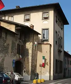 Belli Palace | |
Location of Grassobbio 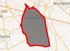
| |
 Grassobbio Location of Grassobbio in Italy 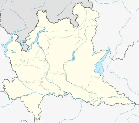 Grassobbio Grassobbio (Lombardy) | |
| Coordinates: 45°39′N 9°43′E | |
| Country | Italy |
| Region | Lombardy |
| Province | Bergamo (BG) |
| Frazioni | Capannelle |
| Government | |
| • Mayor | Manuel Bentoglio (Lega Salvini) |
| Area | |
| • Total | 8.74 km2 (3.37 sq mi) |
| Elevation | 225 m (738 ft) |
| Population | |
| • Total | 6,487 |
| • Density | 740/km2 (1,900/sq mi) |
| Demonym(s) | Grassobbiesi |
| Time zone | UTC+1 (CET) |
| • Summer (DST) | UTC+2 (CEST) |
| Postal code | 24050 |
| Dialing code | 035 |
| ISTAT code | 016117 |
| Patron saint | St. Alexander |
| Saint day | 26 August |
| Website | Official website |
Grassobbio borders the following municipalities: Cavernago, Orio al Serio, Seriate, Zanica.
The town coat of arms is divided into two parts, which represent the past and the present of Grassobbio. On one hand, the past is represented by a castle on fire (in the town center is possible to see and find some ruines of the castle: two towers and a wall). On the other hand, the present is symbolized by an industrial building. In 1961, the district had an industrial boom, which generated an important economic development, leading Grassobbio to become a highly industrialized place.[3]
History
Grassobbio's remote origines date back to the Roman Empire, when small campsites were installed because they were considered a sort of defensive outposts of the southern site of Bergamo province. To support this thesis, tehre are findings of gravestones, which make us think that these settlements interested the passage of a way to communicate between Seriana Valley (Val Seriana) and the level ground, which was a destination for workers.
It is thought that the origins of Grassobbio's name come from a diminutive of the word "grasso", that in the past meant something prolific especially in agricultural terms. To this word was added the suffix -ubulus[4]
At the end of the roman domination, it is thought that Grassobbio went through a depopulation phase, reason why there are no historical written finds or discoveries. The first document, which guarantees the existence of the little town, dates back to 1186, when it was mentioned in an official document edited by the emperor Federico Barbarossa.
It was during the medieval period that the district of Grassobbio knew an important demographic development, thanks to the better economic conditions too. Nevertheless, social and political fields saw the battles between Guelphes and Ghibellines, which interested almost the whole province of Bergamo. This is the reason why the town needed to provide reinforced buildings, such as castles, which were fundamental to protect the territory and the inhabitants.
The situation went back to the normality only at the beginning of the XV century, when the Republic of Venice bust into the province. Thanks to some specific actions it was able to restore the social balance, ending battles and getting up the economy to facilitate the agricultural development.
However, the population lived some other difficult moments, like plague epidemics (the most devastating happened in the XVII century), famines and Serio river floodings, which demolished part of the town center in 1646 and 1920.
The following centuries saw the french domination, until at the end of the XVIII century Austrians replaced them, so they passed definetly to the Kingdom of Italy in 1859, without relevant political facts in Grassobbio.
Only during the second part of the 20th century, the district of Grassobbio had been seeing a progressive economic transformation, to transform it in a little industrial centre. At the boarder of Grassobbio rising up to the Orio al Serio International Airport "Il Caravaggio", so it took to a huge demographic, building and industrial development.[5]
Places of Interest
In the naturalistic field, the eastern part of the country, where the River Serio flows, is inserted in the territory of the Parco del Serio, affected by numerous interventions aimed at upgrading the territory, including the realization of a cycle trackpedestrian and the recovery of the banks of the river.
Very important in the historical context is also what remains of the medieval castle, identified in a rustic building located south of the town, in which you can still recognise elements of life then.
Worthy of note is also the eighteenth-century Palazzo Belli, a large building commissioned by Count Giampaolo Belli, as his home, which now hosts the Municipal Library and the Museum Memories of World wars. Inside are preserved and exposed rooms with high artistic value and many of the most important testimonies of veterans of the fighters of the two world wars.
In the locality of Padergnone there is also an eighteenth-century building, at the time it was a renowned noble residence with works of great value and a large park.
Remarkable is the Sanctuary dedicated to Santa Maria Assunta, inside the oratory, built in 1250, containing valuable works of the Bergamo school.
Significant is the new Church dedicated to the Holy Family of Nazareth built in the vicinity of the sanctuary and consecrated in May 2010 by Monsignor Francesco Beschi, bishop of the province of Bergamo. Until today it is the only church in the province to be completely modern (see the altar, the Risen Christ or the cross on the external front facade).
Finally, it is worth mentioning the parish church of Sant'Alessandro: built in the XIII century and then rebuilt almost completely, following the overflow of Serio in 1646, inside it presents a series of paintings by locals artists of high artistic value.[6]
Infrastructure and transport
As far the road network is concerned, Grassobbio is crossed by SS 042 – del Tonale and della Mendola, SS 498 – Soncinese, and the A4 Torino-Trieste motorway accessible from the Seriate tollbooth, located at less than two kilometers.[7]
The municipality is eleven kilometers from Bergamo, the provincial capital, and it has activated the Public transport service ATB that connects Capannelle-Grassobbio to Bergamo and Città Alta, passing through Orio al Serio with the line 1 (1A Upper Town for the outward and 1C Grassobbio-Capannelle for the return).[8]
Moreover, it is only six kilometers from Bergamo-Orio al Serio International Airpot Il Caravaggio (BGY), reachable via ATB service getting off at the Orio Center stop.
Economy
In the mid 70s, the now multinational chemical manufacturer Sigma Chemicals Company built its second plant in Grassobbio, after starting in Mozzo.[9]
References
- "Superficie di Comuni Province e Regioni italiane al 9 ottobre 2011". Istat. Retrieved 16 March 2019.
- "Statistiche demografiche ISTAT". demo.istat.it. Retrieved 6 December 2020.
- "IL COMUNE – Comune di Grassobbio". www.comune.grassobbio.bg.it (in Italian). Retrieved 15 December 2020.
- "Grassobbio | COMUNE BERGAMO". www.paesi.bergamo.it. Retrieved 15 December 2020.
- "Grassobbio (BG)". www.radiocorriere.tv. Retrieved 15 December 2020.
- "Grassobbio | COMUNE BERGAMO". www.paesi.bergamo.it. Retrieved 15 December 2020.
- "Town of Grassobbio ZIP 24050 (BG) Lombardia, Italy. Full data and useful information also on COVID-19". italia.indettaglio.it. Retrieved 15 December 2020.
- "ATB – Azienda Trasporti Bergamo – Autobus, Orari, Parcheggi, Mobilità". ATB Bergamo (in Italian). Retrieved 15 December 2020.
- "Part of 3V Group – 3V Sigma". www.3vsigma.com. n.d. Retrieved 22 May 2020.
| Authority control |
|---|