Greater Tehran
Greater Tehran is the urban agglomeration around Tehran that covers central part of Tehran Province and eastern part of Alborz Province, that covers the contiguous cities of Tehran, Ray, Shemiranat, and other areas.
Greater Tehran
تهران بزرگ | |
|---|---|
| کلانشهر تهران · Tehran Metropol | |
 | |
 Greater Tehran | |
| Coordinates: 35°41′46″N 51°25′23″E | |
| Country | |
| Province | Tehran |
| Core city | Tehran |
| Area | |
| • Urban | 730 km2 (280 sq mi) |
| • Metro | 9,500 km2 (3,700 sq mi) |
| Elevation | 1,200 to 1,980 m (3,900 to 6,470 ft) |
| Population (2016)[2] | |
| • Density | 1,600/km2 (4,000/sq mi) |
| • Urban | 8,846,782 |
| • Metro | 15,000,000 |
| • Population Rank in Iran | 1st |
| Time zone | UTC+03:30 (IRST) |
| • Summer (DST) | UTC+04:30 (IRDT) |
| Area code(s) | 021 |
| Website | www.tehran.ir |
As of 2012, Greater Tehran had a population of close to 14 million residents.[3] The 2016 census had the population at 13.3 million in Tehran Province (only 200 thousands of them outside Tehran and the suburban counties) and 2.2 million in Karaj and Fardis combined. This allow to estimate that the population of the urban agglomeration was about 15 million people in 2016, and it is sinking 25 cm per year because of the accelerated influx and the overuse of natural resources.[4]
Since the 1960s, much of Greater Tehran's growth has been caused by an influx of urban poor into informal settlements on the fringe.[5]
Greater Tehran should not be confused with the following:
- Tehran Province (area 18814 km², population 13.27 m - 2016). Part of the province is too far from Tehran and has too low a population density to be classified as the part of agglomeration
- Tehran County (area 1300 km², population 8.85 million (2016) with 97.5% of the population living in Tehran City itself)
- Tehran City includes 22 districts, two of them fully and one partially are located outside of Tehran County. The city's area is about 730 km². The extension of the city to other counties began in 1973 to include the villages surrounding the city of Tajrish (Evin, Darakeh, Niyavaran, Rostan Abad, Gholhak, Zargandeh, Elahiyeh, Davoudiyeh, Zarrabkhaneh) and the cities of Vanak and Rey to which “Kooye Siman” had been annexed during the years 1956 to 1966.
Geographys
Tir
Abad
Jandarmeri
Bakhtari
Shemiran
Hosseyn
Abad
No
Ferdows
Sazman-e
Barnameh
Abad
Dastgah
Dastgah
Havayi
No
Chenar
Hassan
Morghi
Fallah
Abad
Niruz
Abad
Daru
Vali-Asr
Bari
Azari
Bokharaee
Abad
Abad
Aban
Qassab
Abad
Babaveyh
Abdol-Azim
Azadi
-Shahr
Haj-Seyf
Cheshmeh
Rah-Ahan
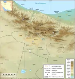
There is no exact definition of Tehran agglomeration borders and composition. Beside Tehran County, also Shemiranat County, Ray County, Eslamshahr County, Pakdasht County, Robat-Karim County, Varamin County, Shahriar County, Qods County, Malard County, Pishva County and Baharestan County in Tehran Province and also Karaj County and probably even Nazarabad County and Savojbolagh County in Alborz Province can be regarded as parts of the agglomeration.
References
- Approximate estimate. Includes ~40% of Tehran Province area and ~2000 km2 of Alborz Province
- Urban population: Data for Tehran County. ~97.5% of county population live in Tehran city
Metro population: Estimate on base of census data, includes central part of Tehran province and Karaj County and Fardis from Alborz province - PopulationData.net – Iran
- https://www.sciencealert.com/this-city-of-15-million-people-is-sinking-rapidly-and-it-could-be-irreversible
- Zebardast, E. (2006). Marginalization of the urban poor and the expansion of the spontaneous settlements on the Tehran metropolitan fringe. Cities, 23(6), 439-454.