Brazzaville
Brazzaville (French pronunciation: [bʁazavil], Kongo: Kintamo, Nkuna, Kintambo, Mavula; Teke: Mfwa, Mfoa, M'fa[3][4][5][6]) is the capital and largest city of the Republic of the Congo (Congo Republic). Constituting the financial and administrative centre of the country, it is located on the north side of the Congo River, opposite Kinshasa, the capital city of the Democratic Republic of the Congo (DR Congo).
Brazzaville
Kintamo, Mfoa | |
|---|---|
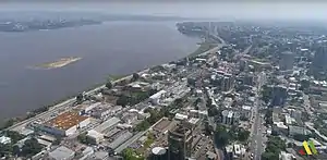 Brazzaville, bird's eye view | |
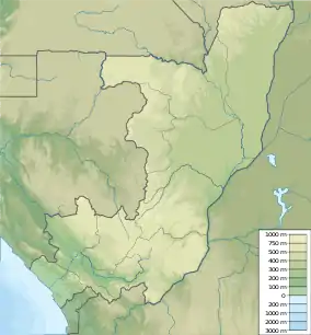 Brazzaville Map of the Republic of Congo showing Brazzaville. 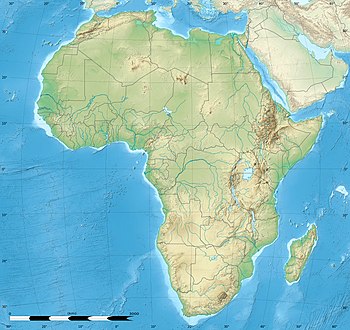 Brazzaville Brazzaville (Africa) | |
| Coordinates: 4°16′4″S 15°17′31″E | |
| Country | Republic of the Congo |
| Capital district | Brazzaville |
| Founded | 1883 |
| Founded by | Pierre Savorgnan de Brazza |
| Government | |
| • Mayor | Christian Roger Okemba (PCT) |
| Area | |
| • Total | 263.9 km2 (101.9 sq mi) |
| Elevation | 320 m (1,050 ft) |
| Population (2015)[1] | |
| • Total | 1,696,392 |
| • Estimate (2019) | 2,308,000 |
| • Density | 6,400/km2 (17,000/sq mi) |
| Area code(s) | 242 |
| HDI (2018) | 0.662[2] medium · 1st of 12 |
| Website | www |
The population of the capital is estimated to exceed 1.8 million residents, comprising more than a third of the national populace. Some 40% are employed in non-agricultural professions. During World War II, Brazzaville was also the capital of Free France between 1940 and 1942.
In 2013, Brazzaville was designated a City of Music by UNESCO; since then it has also been a member of the Creative Cities Network.[7]
Geography
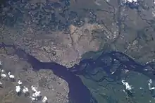
Brazzaville covers a large area to the north of the Congo River, just below the Pool Malebo. Mbamu, a large island within the Pool, is part of the Republic of Congo's territory.
Brazzaville is 506 kilometres (314 miles) inland from the Atlantic Ocean and approximately 474 kilometres (295 miles) south of the equator. The city is a commune that is separated from the other regions of the republic; it is surrounded by the Pool Department. Around the city are large plains. The town is relatively flat, and situated at an altitude of 317 metres (1,040 feet). Downriver the Congo has numerous rapids, known as Livingston Falls, preventing navigation upriver to this point from its mouth at the Atlantic.
Kinshasa, the capital of the Democratic Republic of the Congo, is located on the southern bank of the Congo, directly across from Brazzaville. To distinguish between the two African countries that have "Congo" in their names, the Republic of the Congo is sometimes called Congo-Brazzaville, as opposed to Congo-Kinshasa. Kinshasa is more than five times larger than Brazzaville in population. This is the only place in the world where two national capital cities developed on opposite banks of a river, within sight of each other.[8]
In March 2018, the "Brazzaville Declaration" was signed to promote better management and conservation of the Cuvette Centrale, a region in Congo basin and primarily in DRC. It is the world's largest tropical peatland, made up of swamp forests. Conservation of this area is important for the survival of megafauna, and also critical to the world's climate. Burning the peat would release too much carbon and raise the earth's temperature. The declaration to save peatlands as the world's largest terrestrial organic carbon stock was signed by Democratic Republic of Congo, the Republic of Congo, and Indonesia, which also has peatlands.[9]
History
Brazzaville was founded by the French colonial empire upon an existing indigenous Bateke settlement called Ncuna, during the Scramble for Africa when European nations established spheres of influence on the continent.[10] The Italian-born explorer Pierre Savorgnan de Brazza, who was granted French citizenship in 1874, officially founded the settlement on 10 September 1880; it commemorates his name .[11][10]
The local King, Makoko of the Téké, signed a treaty of protection with de Brazza, which subjugated his lands to the French Empire.[10] From October 1880 until May 1882, a small squad of troops led by Senegalese Sergeant Malamine Camara occupied the site, in order to prevent the land from falling into Belgian hands. Their forces were active on the south side of the river, where King Leopold II ruled the Belgian Congo for a period as a private holding. The first large-scale building work of the city began four years later, as the French competed with Léopoldville (now Kinshasa) which Belgian colonists were developing on the south side of the river.[10]
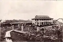
The Berlin Conference of 1884 placed French control over this area on an official footing. The city became the capital of the French Congo in 1904.[12] It continued as capital when French Equatorial Africa was founded in 1910, as a federation of French colonial states: it included Gabon, the Central African Republic, and Chad until 1960.[12] From 1910–1915 the major municipal buildings were constructed, including a courthouse and headquarters for the Banque de l'AEF and Institut Pasteur.[13]
In 1934 the Congo–Ocean Railway opened, linking Brazzaville with the Atlantic port of Pointe-Noire and bypassing the rapids on the Congo River. Construction of the railway resulted in the deaths of more than 17,000 Africans, and the people revolted against the French in 1928.[14]
During World War II Brazzaville and the rest of French Equatorial Africa remained beyond the control of Vichy France, which served the Nazi occupation. The city served as the capital of France Libre from 1940–1943.[13] In 1944, Brazzaville hosted a meeting of the French resistance forces and representatives of France's African colonies. The resulting Brazzaville Declaration represented an attempt to redefine the relationship between France and its African colonies.[12]
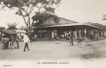
Until the 1960s, the city was divided into European (the centre of the city) and African sections (Poto-Poto, Bacongo, and Makélékélé). In 1980 it became a "commune," separated from the surrounding Pool Department and divided into nine "arrondissements" (boroughs) along the French model of administration.
Since the late 20th century, the city has frequently been a staging ground for wars, including internal conflicts between rebel and government forces. It has been a base of conflicts between forces of the Republic of the Congo, the Democratic Republic of the Congo (DRC), and Angola. During the 1990s, civil wars resulted in thousands of civilian deaths here and forced hundreds of thousands of refugees to flee the city.
More recently thousands of people leaving the DRC have made their way to Brazzaville; the local United Nations force and the DRC government have accused the city of deporting thousands of these refugees.[15][16]
In April 2016 fighting occurred between police and local militia units, with at least 18 people killed.[17]
Demographics
| Year | Pop. | ±% |
|---|---|---|
| 1984 | 585,812 | — |
| 1996 | 856,410 | +46.2% |
| 2007 | 1,373,382 | +60.4% |
| 2019 | 2,175,000 | +58.4% |
As of the 2007 census, the city had a population of 1.37 million. The projection of the CNSEE (national statistics centre) estimated an increase to 1.7 million by 2015,[18] but the projection was made before 2007 and was based on a lower estimate of the population (1.26 million) than that recorded in the census.
The United Nations Population Division estimate for 2014 is 1.83 million. Kinshasa, DRC, had more than 10 million inhabitants in 2014.[19]
Together with Kinshasa, the combined conurbation of Kinshasa-Brazzaville has about 12 million inhabitants. Significant political and infrastructure challenges prevent the two cities from functioning with any meaningful connection.[20] [21]
Since the mid-19th century, the two cities have been rivals in trade, sports and power.[8] There have been proposals to connect the two capitals by a Brazzaville–Kinshasa Bridge. In 2018, with relative peace re-established in the region, the African Development Bank and Africa50 signed a deal with both governments to develop the project.[22]
Government
Brazzaville, like Pointe-Noire, has the status of both a commune (municipality) and a department. It is governed by a municipal council and a departmental council. The mayor is the president of the municipal council.[23]
The city is divided into nine arrondissements (boroughs):[24]
Economy
The location of Brazzaville near the pool of the Congo River enabled it to grow as an industrial, trading and port settlement. It was connected through trade by ships and boats traveling upriver to inland areas, which produced raw materials from the beginning of the colonial period.[12] Construction of the railway connecting to Pointe-Noire increased the ability of city businessmen to get their products to the port for export. Industries present in Brazzaville include machine shops, textiles, tanning, and manufacturing. As a key port on the Congo River, Brazzaville still takes deliveries of raw materials, such as rubber, wood, and agricultural products. From here they are generally sent onward to Pointe-Noire for export.
Many companies, government organizations and NGOs have regional offices in the capital city, where they can work with government officials. The World Health Organization has its regional office for Africa located in Brazzaville.[25] Companies headquartered in Brazzaville include Equatorial Congo Airlines[26] and the mobile operator Warid Congo.[27]
Culture
Erell, a highly regarded architect, also designed a house in the city for Charles de Gaulle when he was the leader of Free France here. Other buildings include the Pierre Savorgnan de Brazza Mausoleum, the Nabemba Tower, and the Congressional Palace (Brazzaville).
The Marien Ngouabi Mausoleum, Brazzaville Zoo, and the Poto-Poto School of Painting are also destinations for visitors and city residents.
Places of worship
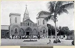
Many Congolese converted to Catholicism during the French colonial period. Christian churches are most prevalent in the city, where the Roman Catholic Church has an Archdiocese. Since then, churches have been established by new immigrants and by local adoption of evangelical Protestantism. Examples include the Greek Orthodox Archdiocese of Brazzaville and Gabon (Patriarchate of Alexandria and All Africa), Evangelical Church of Congo (World Communion of Reformed Churches), and Assemblies of God.[28]
Education
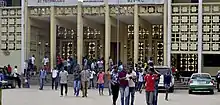
The Marien Ngouabi University is a public university in Brazzaville, named after a former leader.[29] The university was founded in December 1971 after independence. Today it has approximately 26,000 students.[29]
International schools:
- Lycée Français Saint-Exupéry de Brazzaville (French)
- American International School of Brazzaville
Climate
Brazzaville features a tropical wet and dry climate. Its wet season, which runs from October–May, is longer than its dry season, which covers the remaining months. Brazzaville's driest months, July and August, on average have no significant precipitation. Since Brazzaville is south of the equator, its dry season begins at around its "winter" solstice, which is the month of June. The city has relatively consistent temperatures throughout the course of the year.
| Climate data for Brazzaville (Maya-Maya Airport) 1961–1990, extremes 1932–present | |||||||||||||
|---|---|---|---|---|---|---|---|---|---|---|---|---|---|
| Month | Jan | Feb | Mar | Apr | May | Jun | Jul | Aug | Sep | Oct | Nov | Dec | Year |
| Record high °C (°F) | 37.5 (99.5) |
36.3 (97.3) |
37.5 (99.5) |
36.8 (98.2) |
37.3 (99.1) |
34.3 (93.7) |
33.8 (92.8) |
40.2 (104.4) |
39.5 (103.1) |
38.9 (102.0) |
35.8 (96.4) |
40.2 (104.4) |
40.2 (104.4) |
| Average high °C (°F) | 30.5 (86.9) |
31.3 (88.3) |
31.7 (89.1) |
31.8 (89.2) |
30.9 (87.6) |
28.4 (83.1) |
27.0 (80.6) |
28.5 (83.3) |
30.4 (86.7) |
30.8 (87.4) |
30.4 (86.7) |
30.2 (86.4) |
30.2 (86.4) |
| Daily mean °C (°F) | 26.0 (78.8) |
26.4 (79.5) |
26.7 (80.1) |
26.8 (80.2) |
26.2 (79.2) |
23.8 (74.8) |
22.4 (72.3) |
23.6 (74.5) |
25.5 (77.9) |
26.1 (79.0) |
25.9 (78.6) |
25.8 (78.4) |
25.4 (77.7) |
| Average low °C (°F) | 21.4 (70.5) |
21.5 (70.7) |
21.7 (71.1) |
21.9 (71.4) |
21.6 (70.9) |
19.3 (66.7) |
17.8 (64.0) |
18.8 (65.8) |
20.6 (69.1) |
21.4 (70.5) |
21.4 (70.5) |
21.5 (70.7) |
20.7 (69.3) |
| Record low °C (°F) | 17.0 (62.6) |
14.5 (58.1) |
17.7 (63.9) |
18.6 (65.5) |
17.0 (62.6) |
12.7 (54.9) |
10.5 (50.9) |
10.3 (50.5) |
15.2 (59.4) |
13.7 (56.7) |
18.2 (64.8) |
17.7 (63.9) |
10.3 (50.5) |
| Average precipitation mm (inches) | 160 (6.3) |
137 (5.4) |
167 (6.6) |
191 (7.5) |
118 (4.6) |
8 (0.3) |
3 (0.1) |
4 (0.2) |
34 (1.3) |
139 (5.5) |
261 (10.3) |
172 (6.8) |
1,394 (54.9) |
| Average precipitation days (≥ 1.0 mm) | 10 | 8 | 11 | 12 | 8 | 1 | 0 | 0 | 4 | 9 | 14 | 12 | 89 |
| Average relative humidity (%) | 81 | 80 | 79 | 81 | 81 | 79 | 77 | 73 | 71 | 76 | 81 | 82 | 78 |
| Mean monthly sunshine hours | 171 | 167 | 192 | 181 | 177 | 141 | 127 | 133 | 145 | 152 | 157 | 154 | 1,897 |
| Source 1: Deutscher Wetterdienst (humidity, 1951–1990)[30][31][lower-alpha 1] | |||||||||||||
| Source 2: Meteo Climat (record highs and lows)[32] | |||||||||||||
Transport
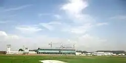
The city is home to Maya-Maya Airport, which lies in the centre of the city and which has regular flights to Pointe-Noire as well as international destinations in Africa, Europe and the Middle East. A flight operates twice weekly between Brazzaville and Kinshasa, but the flight time is only five minutes.[8]
.jpg.webp)
The Congo-Ocean Railway has a station in the city and in 2014 was operating the La Gazelle train service every other day to Pointe-Noire and intermediate destinations.[33]
The city is an important river port, with ferries sailing to Kinshasa and to Bangui via Impfondo.[8] Ferries and fast private boats serve as the primary means of connection between Kinshasa and Brazzaville.[8] The Livingstone Falls lie on the outskirts of the city, where the Djoué River meets the Congo, rendering river transport to the coast impossible, qualifying the railway as a portage railway.
Although there is no organised public transport system, privately owned buses are available in the capital.[34]
Taxis are available on every street and are easily recognized, being painted with a green body and white top, and the fare for a short trip is CF700. About twenty percent of the vehicles in Brazzaville are taxis. There are also collective taxis that drive certain routes and charge CF150.
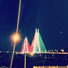
A road-rail bridge is proposed to connect Brazzaville with Kinshasa. The rail gauge on both sides is the same at 1067mm. [35]
Notable people
- Gaitana, Ukrainian singer who lived in Brazzaville for five years.
- Serge Ibaka, professional basketball player born in Brazzaville.
- Cyril Kongo, a French painter and graffiti artist, lived in Brazzaville in the 80s.
- Verone Mankou, a congolese entrepreneur who launched the first ever African tab smartphone
Twin towns and sister cities
See also
- Avenue Matsoua
Notes
- Station ID for Brazzaville/ Maya–Maya is 64450 Use this station ID to locate the sunshine duration
References
- "Répartition de la population par". cnsee.org. Retrieved 31 March 2020.
- "Sub-national HDI - Area Database - Global Data Lab". hdi.globaldatalab.org. Retrieved 13 September 2018.
- Roman Adrian Cybriwsky, Capital Cities around the World: An Encyclopedia of Geography, History, and Culture, ABC-CLIO, USA, 2013, p. 60
- Sylvie Ayimpam, Vie matérielle, échanges et capitalisme sur la rive méridionale du Pool du fleuve Congo (1815-1930), Centre d’Étude des Mondes Africains (CEMAf), 2006, p. 4 and p. 9
- Joseph ZIDI, Brazzaville : Les enjeux de la géographie des migrations (1800-2010), Université Marien Ngouabi de Brazzaville, 2016
- MARTIN Phyllis M., Loisirs et société à Brazzaville pendant l'ère coloniale, KARTHALA Editions, 2006, p. 31
- "Brazzaville, Zahlé, Kraków and Fabriano designated UNESCO Creative Cities". UN News. 21 October 2013. Retrieved 3 October 2018.
- "Face-off over the Congo: the long rivalry between Kinshasa and Brazzaville". Retrieved 15 July 2017.
- "Historic agreement signed to protect the world's largest tropical peatland". UNEP - UN Environment Programme.
- Pakenham, Thomas (1991). The Scramble for Africa. Abacus. p. 150.
- Roman Adrian Cybriwsky, Capital Cities around the World: An Encyclopedia of Geography, History, and Culture, ABC-CLIO, USA, 2013, p. 60
- Thomas, Dominic (2005). Encyclopedia of Twentieth-Century African History. Routledge.
- Jean-Jacques Youlou & Scholastique Dianzinga, "Une capitale dans l'histoire"; Chapter 1 in Ziavoula (2006).
- "Republic of Congo profile". BBC. 11 April 2017.
- "Deportation comments anger Congo", Independent Online (SAPA-AFP), 28 May 2014.
- James Butty, "DRC Threatens Legal Action over Deportations from Congo-Brazzaville", VOA News, 27 May 2014.
- "Heavy gunfire in Congo-Brazzaville capital as police battle militia". The Guardian. Retrieved 15 July 2017.
- "Répartition de la population par Départements et Communes en 1984 et projetée de 2000 à 2015" (in French). Centre National de la Statistique et des Études Économiques (CNSEE), Republic of the Congo. Retrieved 27 October 2013.
- "Monographie de la Ville de Kinshasa" (in French). Unité de Pilotage du Processus d'Elaboration et de mise œuvre de la Stratégie pour la Réduction de la Pauvreté (UPPE-SRP). Archived from the original (SWF) on 9 February 2007. Retrieved 19 January 2007.
- "Congo (Rep.): Departments, Major Cities & Towns - Population Statistics in Maps and Charts". citypopulation.de.
- "Major Agglomerations of the World - Population Statistics and Maps". www.citypopulation.de.
- Siphelele Dludla, "DRC, Congo sign $500m deal to build Kinshasa-Brazzaville connecting bridge", IOL, 8 November 2018
- Brazzaville.cg (site officiel de la commune de Brazzaville), "L'administration municipale"; accessed 16 July 2017.
- "Les arrondissements". Brazzaville.cg (in French). Commune de Brazzaville, Congo. Archived from the original on 12 September 2017. Retrieved 12 September 2017.
- "WHO | Regional Office for Africa". WHO.
- "ECAir Fleet Details and History". www.planespotters.net. Retrieved 5 June 2016.
- "Company Overview of Warid Congo S.A."
- J. Gordon Melton, Martin Baumann, Religions of the World: A Comprehensive Encyclopedia of Beliefs and Practices, ABC-CLIO, USA, 2010, p. 773
- "Quick Facts". Archived from the original on 4 September 2018. Retrieved 15 July 2017.
- "Klimatafel von Brazzaville (Flugh.) / Kongo" (PDF). Baseline climate means (1961–1990) from stations all over the world (in German). Deutscher Wetterdienst. Retrieved 24 October 2016.
- "Station 64450 Brazzaville/ Maya–Maya". Global station data 1961–1990—Sunshine Duration. Deutscher Wetterdienst. Archived from the original on 17 October 2017. Retrieved 24 October 2016.
- "Station Brazzaville" (in French). Meteo Climat. Retrieved 24 October 2016.
- Planet, Lonely. "La Gazelle train Brazzaville to Pointe Noire".
- "Archived copy". Archived from the original on 25 January 2010. Retrieved 27 September 2014.CS1 maint: archived copy as title (link)
- Road-Rail Bridge
- "Coopération". Brazzaville.cg (in French). Commune de Brazzaville, Congo. Archived from the original on 5 September 2017. Retrieved 12 September 2017.
Bibliography
- Ziavoula, Robert Edmond, ed. (2006). Brazzaville, une ville à reconstruire. Paris: Karthala. ISBN 2-84586-825-1.
Notes
- Chavannes, Charles de. (1929) "Le Sergent Sénégalais Malamine." Annales de l'Académie des Sciences Coloniales, vol. 3:159–187.
- Petringa, Maria. (2006) Brazza, A Life for Africa (2006) ISBN 978-1-4259-1198-0
- Tiepolo, M. (1996) "City Profile: Brazzaville" in Cities v. 13, pp. 117–124
- Brisset-Guibert, Hervé (2007) Brazzaville petit guide historique, in the site www.presidence.cg ("palais presidentiel")
- Cultural reference: In the final scene of the 1942 film, Casablanca, it is to Brazzaville that Captain Renault (Claude Rains) suggests he and Rick (Humphrey Bogart) might escape to together for "vacation" and, as Rick counters, "the beginning of a beautiful friendship."
- Whitehouse, Bruce (2012). Migrants and Strangers in an African City: Exile, Dignity, Belonging. Bloomington: Indiana University Press. ISBN 9780253000811.
External links
| Wikimedia Commons has media related to Brazzaville. |
- BRAKIN, the fusion city of Brazzaville and Kinshasa, urban analysis seminar with vectorised maps of the agglomeration by TU Darmstadt, 2009
- Maria Petringa's 1997 biographical article on Savorgnan de Brazza, describing events leading to the founding of Brazzaville
 Brazzaville travel guide from Wikivoyage
African Games host cities | |
|---|---|
| Authority control |
|---|