Gypsite, California
Gypsite is an unincorporated community in Kern County, California.[1]
Gypsite | |
|---|---|
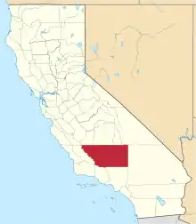
 Gypsite Location in California  Gypsite Gypsite (the United States) | |
| Coordinates: 35°19′52″N 117°55′52″W | |
| Country | United States |
| State | California |
| County | Kern County |
| Elevation | 1,959 ft (597 m) |
It is located 3 miles (4.8 km) southwest of Saltdale, in the Fremont Valley of the Mojave Desert [2] at an elevation of 1,959 feet (597 m).[1] It is located near Koehn Lake south-southwest of Ridgecrest near Garlock, California.
In late 1909[3] Charles Koehn found a large deposit of gypsite (a mixture of gypsum and clay) in the bed of Koehn Lake. In 1910[4] or 1911, the California Crown Plaster & Gypsite Company leased Koehn's claims and built a mill at Kane (Cane) Spring,[5] located just north of Gypsite.[6][7] A post office operated at Gypsite from June 1911 to March 1912.[2][5] During the summer of 1912, 12 men produced 30 tons of plaster per day.[5] In 1913, a 3 mile narrow-gauge railroad was built on the lake bed. The company also built a hotel, houses, a depot and a post office (which was never reopened).[5]
In 1915, the operation failed and Koehn took over the mill. Production was intermittent until 1928, when Koehn was convicted of attempted murder of a San Bernardino judge and Koehn lost control of the site. George Abel took over production until his death in the early 1930s. Intermittent production again continued until the 1950s.[5]
References
- U.S. Geological Survey Geographic Names Information System: Gypsite, California
- Durham, David L. (1998). California's Geographic Names: A Gazetteer of Historic and Modern Names of the State. Clovis, Calif.: Word Dancer Press. p. 1043. ISBN 1-884995-14-4.
- Hess, Frank L. (1909). Gypsum Deposits near Cane Springs, Kern County, California (Report). US Geological Survey. pp. 417–418. Retrieved December 29, 2020.
- Hess, F.L. (1920). Stone, R.W. (ed.). Gypsum Deposits of the United States (PDF) (Report). US Geological Survey. p. 73. Retrieved December 29, 2020.
- Hensher, Alan. "Gypsite: A Humble Product from a Humble Camp" (PDF). SBCMA Quarterly. Vol. 45 no. 1, 2. San Bernardino County Museum. Retrieved December 29, 2020.
- Searles Lake (Map) (1915 ed.). 1:250,000. 1915. Shown as Cane Spring.
- Searles Lake (Map) (1922 ed.). 1:250,000. 1915. Shown as Koehn Spring.
External links
- "Kane Springs/Gypsite". Rand Desert Museum. Retrieved December 29, 2020. - Newspaper articles about Gypsite