Rosamond, California
Rosamond is a census-designated place (CDP) in Kern County, California, USA, near the Los Angeles county line. Rosamond is part of Greater Los Angeles and is located in the Mojave Desert just north of Lancaster and Palmdale, two of the largest cities in Antelope Valley. As of the 2010 Census, Rosamond's population was 18,150.[3]
Rosamond | |
|---|---|
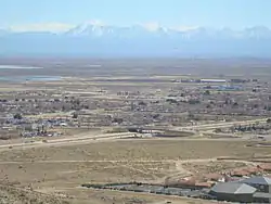 View of part of Rosamond, CA | |
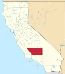
 Location in Kern County and the state of California | |
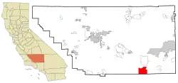
 Rosamond Location in the United States | |
| Coordinates: 34°51′51″N 118°09′48″W | |
| Country | |
| State | |
| County | Kern |
| Government | |
| • Senate | Jean Fuller (R) |
| • Assembly | Tom Lackey (R) |
| • U. S. Congress | Kevin McCarthy (R) |
| Area | |
| • Total | 52.336 sq mi (135.550 km2) |
| • Land | 52.121 sq mi (134.993 km2) |
| • Water | 0.215 sq mi (0.557 km2) 0.41% |
| Elevation | 2,517 ft (767 m) |
| Population (2010) | |
| • Total | 18,150 |
| • Density | 350/sq mi (130/km2) |
| Time zone | UTC-8 (PST) |
| • Summer (DST) | UTC-7 (PDT) |
| ZIP code | 93560 |
| Area code(s) | 661 |
| FIPS code | 06-62826 |
| GNIS feature ID | 1661329 |
Rosamond is a suburban bedroom community with many residents employed by nearby Edwards Air Force Base or commuting to Los Angeles, Lancaster, and Palmdale for work. The town is about 15 minutes north of the Lancaster Metrolink station providing direct access to Los Angeles Union Station in just two hours.
History
Rosamond was established in 1877 as a townsite owned by the Southern Pacific Railroad; it was named for the daughter of one of the railroad's officials.[4][5] The first local industries were mining and cattle. During the 1890s, gold was discovered in the area, quickly drawing miners and prospectors. After the initial boom, gold mining gradually declined, though it had a second, smaller boom during the 1930s. In 1933, Muroc Army Air Field was established some 20 miles away; it was later renamed Edwards Air Force Base in honor of fallen test pilot Glenn Edwards.
The Rosamond post office opened in 1885, closed in 1887, and re-opened in 1888.[4]
Geography
Rosamond sits in the northern end of the Antelope Valley, the westernmost valley of the Mojave Desert. Because the elevation is 2,000 to 3,000 feet (610 to 910 m) above sea level, the area, like the other parts of the Mojave Desert region, is referred to as the High Desert. Some cities and communities within the trading area of Rosamond include Lancaster, Palmdale, Hi Vista, Roosevelt, Redman, Lake Los Angeles, Quartz Hill, Ridgecrest, and Santa Clarita. Residents of these desert cities and unincorporated communities share Sierra Highway, Angeles Forest Highway, Angeles Crest Highway (State Route 2), and the Antelope Valley Freeway (State Route 14) for commutes to the San Fernando Valley and Los Angeles Basin in order to get to work.
Willow Springs lies west of central Rosamond and was a watering hole for stagecoach travelers for generations, though its springs have dried up. Willow Springs Raceway is nearby, which hosts a variety of motor racing events, attracting people from all over Southern California and beyond.
Rosamond is located at 34°51′51″N 118°09′48″W.[2]
According to the United States Census Bureau, the CDP has a total area of 52.336 square miles (135.550 km2), of which, 52.121 square miles (134.993 km2) of it is land and 0.215 square miles (0.557 km2) of it (0.41%) is water.
Demographics
2010
At the 2010 census Rosamond had a population of 18,150. The population density was 346.8 people per square mile (133.9/km2). The racial makeup of Rosamond was 11,294 (62.2%) White, 1,476 (8.1%) African American, 221 (1.2%) Native American, 658 (3.6%) Asian, 66 (0.4%) Pacific Islander, 3,258 (18.0%) from other races, and 1,177 (6.5%) from two or more races. Hispanic or Latino of any race were 6,230 persons (34.3%)[6]
The census reported that 18,145 people (100% of the population) lived in households, 5 (0%) lived in non-institutionalized group quarters, and no one was institutionalized.
There were 6,197 households, 2,603 (42.0%) had children under the age of 18 living in them, 3,254 (52.5%) were opposite-sex married couples living together, 843 (13.6%) had a female householder with no husband present, 390 (6.3%) had a male householder with no wife present. There were 432 (7.0%) unmarried opposite-sex partnerships, and 40 (0.6%) same-sex married couples or partnerships. 1,317 households (21.3%) were one person and 342 (5.5%) had someone living alone who was 65 or older. The average household size was 2.93. There were 4,487 families (72.4% of households); the average family size was 3.43.
The age distribution was 5,290 people (29.1%) under the age of 18, 1,956 people (10.8%) aged 18 to 24, 4,708 people (25.9%) aged 25 to 44, 4,716 people (26.0%) aged 45 to 64, and 1,480 people (8.2%) who were 65 or older. The median age was 32.0 years. For every 100 females, there were 100.6 males. For every 100 females age 18 and over, there were 100.2 males.
There were 6,968 housing units at an average density of 133.1 per square mile, of the occupied units 4,202 (67.8%) were owner-occupied and 1,995 (32.2%) were rented. The homeowner vacancy rate was 4.5%; the rental vacancy rate was 12.7%. 12,388 people (68.3% of the population) lived in owner-occupied housing units and 5,757 people (31.7%) lived in rental housing units.
2000
At the 2000 census there were 14,349 people, 4,988 households, and 3,626 families in the CDP. The population density was 274.7 people per square mile (106.1/km2). There were 5,597 housing units at an average density of 107.2 per square mile (41.4/km2). The racial makeup of the CDP was 72.01% White, 6.62% Black or African American, 1.32% Native American, 3.01% Asian, 0.23% Pacific Islander, 11.65% from other races, and 5.16% from two or more races.[7] Of the 4,988 households 41.2% had children under the age of 18 living with them, 54.7% were married couples living together, 12.5% had a female householder with no husband present, and 27.3% were non-families. 21.9% of households were one person and 6.2% were one person aged 65 or older. The average household size was 2.88 and the average family size was 3.38.
The age distribution was 32.9% under the age of 18, 7.9% from 18 to 24, 32.0% from 25 to 44, 19.3% from 45 to 64, and 7.9% 65 or older. The median age was 33 years. For every 100 females, there were 102.4 males. For every 100 females age 18 and over, there were 101.5 males.
The median household income was $42,307 and the median family income was $46,918. Males had a median income of $42,484 versus $26,745 for females. The per capita income for the CDP was $17,440. About 11.6% of families and 14.1% of the population were below the poverty line, including 19.2% of those under age 18 and 12.0% of those age 65 or over.
Education
There are five schools in Rosamond: Rosamond Elementary School, West Park Elementary School, Tropico Middle School, Rosamond High School and Rare Earth High School (alternative education).[8]
Transportation
Rosamond sits along the California State Route 14, also known as the Antelope Highway, providing direct access to Los Angeles to the south and Mojave to the north.
Bus service from Rosamond to Bakersfield and Lancaster is provided by Kern Transit. The nearest Metrolink station is located about 15 minutes south in Lancaster. Expansion of the Metrolink train north to Rosamond has been discussed in a 2012 Kern County Council of Governments report.[9][10][11]
References
| Wikivoyage has a travel guide for Rosamond. |
- U.S. Census Archived 2012-01-25 at the Wayback Machine
- U.S. Geological Survey Geographic Names Information System: Rosamond, California
- "U.S. Census Bureau QuickFacts: Rosamond CDP, California". www.census.gov. Retrieved 25 October 2020.
- Durham, David L. (1998). California's Geographic Names: A Gazetteer of Historic and Modern Names of the State. Clovis, Calif.: Word Dancer Press. p. 1098. ISBN 1-884995-14-4.
- Capace, Nancy (1999). Encyclopedia of California. North American Book Dist LLC. Page 393. ISBN 9780403093182.
- "2010 Census Interactive Population Search: CA - Rosamond CDP". U.S. Census Bureau. Archived from the original on July 15, 2014. Retrieved July 12, 2014.
- "U.S. Census website". United States Census Bureau. Retrieved 2008-01-31.
- District Schools, Southern Kern Unified School District, retrieved April 18, 2014.
- "Draft report" (PDF). kerncog.org. 2010. Retrieved 2019-11-13.
- "Commuter Rail Report" (PDF). www.kerncog.org. 2012. Retrieved 2019-09-28.
- "Rail System Plan" (PDF). scagrtpscs.net. 2016. Retrieved 2019-09-28.
- Fay, Sarah. "Paris Review – The Art of Poetry No. 94, Kay Ryan". The Paris Review. Retrieved 2010-09-16.