Hå
Hå is a municipality in Rogaland county, Norway. It is the southernmost municipality in the traditional district of Jæren. The administrative centre of the municipality is the village of Varhaug. Other villages in Hå include Brusand, Hæen, Nærbø, Obrestad, Ogna, Sirevåg, and Vigrestad.
Hå kommune | |
|---|---|
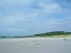
 View of the Brusandstrand beach in Hå | |
 Rogaland within Norway | |
 Hå within Rogaland | |
| Coordinates: 58°36′23″N 05°43′29″E | |
| Country | Norway |
| County | Rogaland |
| District | Jæren |
| Established | 1838-1894 |
| Re-established | 1 Jan 1964 |
| Administrative centre | Varhaug |
| Government | |
| • Mayor (2015) | Jonas Skrettingland (KrF) |
| Area | |
| • Total | 257.99 km2 (99.61 sq mi) |
| • Land | 247.78 km2 (95.67 sq mi) |
| • Water | 10.21 km2 (3.94 sq mi) 4% |
| Area rank | 281 in Norway |
| Population (2020) | |
| • Total | 18,991 |
| • Rank | 66 in Norway |
| • Density | 76.6/km2 (198/sq mi) |
| • Change (10 years) | 16.2% |
| Demonym(s) | Håbu[1] |
| Time zone | UTC+01:00 (CET) |
| • Summer (DST) | UTC+02:00 (CEST) |
| ISO 3166 code | NO-1119 |
| Official language form | Neutral[2] |
| Website | ha |

The 258-square-kilometre (100 sq mi) municipality is the 281st largest by area out of the 356 municipalities in Norway. Hå is the 66th most populous municipality in Norway with a population of 18,991. The municipality's population density is 76.6 inhabitants per square kilometre (198/sq mi) and its population has increased by 16.2% over the previous 10-year period.[3][4]
General information

| Year | Pop. | ±% |
|---|---|---|
| 1971 | 10,607 | — |
| 1981 | 12,327 | +16.2% |
| 1991 | 13,022 | +5.6% |
| 2001 | 14,017 | +7.6% |
| 2011 | 16,822 | +20.0% |
| 2020 | 18,991 | +12.9% |
| Source: Statistics Norway.[5] | ||
The parish of Haa was established as a municipality on 1 January 1838 (see formannskapsdistrikt law). In 1894, the municipality of Haa was dissolved and divided into two new municipalities: Nærbø (population: 1,806) and Varhaug (population: 1,801). During the 1960s, there were many municipal mergers across Norway due to the work of the Schei Committee. On 1 January 1964, the municipality of Hå was recreated by merging of the neighboring municipalities of Nærbø (population: 3,926), Varhaug (population: 3,454), and Ogna (population: 1,470).[6] In local politics, the divisions between the three previous municipalities are very visible.
Name
The municipality is named after the old Hå farm (Old Norse: Háar) where the local church priest's parsonage was located. The meaning of the name is unknown. The river running past this farm is similarly named the Hååna, meaning the "Hå river". It is not known if the river is named after the farm or vice versa.[7]
Coat of arms
The coat of arms was granted on 5 July 1991. The arms are black with a silver/white winch in the centre. It is a special type of winch that has historically been used in this area to remove stones from the many farm fields. The arms were chosen to symbolize the hard living on the rocky soils of the municipality.[8]
Churches
The Church of Norway has three parishes (sokn) within the municipality of Hå. It is part of the Jæren prosti (deanery) in the Diocese of Stavanger.
| Parish (sokn) | Church name | Location of the church | Year built |
|---|---|---|---|
| Nærbø | Nærbø Church | Nærbø | 2005 |
| Old Nærbø Church | Nærbø | 1834 | |
| Ogna | Ogna Church | Ogna | 1250 |
| Varhaug | Varhaug Church | Varhaug | 1904 |
Government
All municipalities in Norway, including Hå, are responsible for primary education (through 10th grade), outpatient health services, senior citizen services, unemployment and other social services, zoning, economic development, and municipal roads. The municipality is governed by a municipal council of elected representatives, which in turn elect a mayor.[9] The municipality falls under the Jæren District Court and the Gulating Court of Appeal.
Municipal council
The municipal council (Kommunestyre) of Hå is made up of 33 representatives that are elected to four year terms. Currently, the party breakdown is as follows:
| Party Name (in Norwegian) | Number of representatives | |
|---|---|---|
| Labour Party (Arbeiderpartiet) | 3 | |
| Progress Party (Fremskrittspartiet) | 3 | |
| Conservative Party (Høyre) | 5 | |
| Christian Democratic Party (Kristelig Folkeparti) | 7 | |
| Centre Party (Senterpartiet) | 5 | |
| Socialist Left Party (Sosialistisk Venstreparti) | 1 | |
| Hå List (Hå-lista) | 9 | |
| Total number of members: | 33 | |
| Party Name (in Norwegian) | Number of representatives | |
|---|---|---|
| Labour Party (Arbeiderpartiet) | 3 | |
| Progress Party (Fremskrittspartiet) | 3 | |
| Conservative Party (Høyre) | 6 | |
| Christian Democratic Party (Kristelig Folkeparti) | 7 | |
| Centre Party (Senterpartiet) | 3 | |
| Nærbø List (Nærbølista) | 10 | |
| Common list for southern Hå (Samlingsliste for søre Hå) | 1 | |
| Total number of members: | 33 | |
| Party Name (in Norwegian) | Number of representatives | |
|---|---|---|
| Labour Party (Arbeiderpartiet) | 3 | |
| Progress Party (Fremskrittspartiet) | 3 | |
| Conservative Party (Høyre) | 7 | |
| Christian Democratic Party (Kristelig Folkeparti) | 6 | |
| Centre Party (Senterpartiet) | 3 | |
| Nærbø List (Nærbølista) | 11 | |
| Total number of members: | 33 | |
| Party Name (in Norwegian) | Number of representatives | |
|---|---|---|
| Labour Party (Arbeiderpartiet) | 2 | |
| Progress Party (Fremskrittspartiet) | 4 | |
| Conservative Party (Høyre) | 3 | |
| Christian Democratic Party (Kristelig Folkeparti) | 7 | |
| Centre Party (Senterpartiet) | 4 | |
| Socialist Left Party (Sosialistisk Venstreparti) | 1 | |
| Nærbø List (Nærbølista) | 12 | |
| Total number of members: | 33 | |
| Party Name (in Norwegian) | Number of representatives | |
|---|---|---|
| Labour Party (Arbeiderpartiet) | 3 | |
| Progress Party (Fremskrittspartiet) | 5 | |
| Conservative Party (Høyre) | 4 | |
| Christian Democratic Party (Kristelig Folkeparti) | 7 | |
| Centre Party (Senterpartiet) | 6 | |
| Socialist Left Party (Sosialistisk Venstreparti) | 2 | |
| Nærbø List (Nærbølista) | 6 | |
| Total number of members: | 33 | |
| Party Name (in Norwegian) | Number of representatives | |
|---|---|---|
| Labour Party (Arbeiderpartiet) | 3 | |
| Progress Party (Fremskrittspartiet) | 5 | |
| Conservative Party (Høyre) | 6 | |
| Christian Democratic Party (Kristelig Folkeparti) | 8 | |
| Centre Party (Senterpartiet) | 7 | |
| Socialist Left Party (Sosialistisk Venstreparti) | 2 | |
| Nærbø List (Nærbølista) | 6 | |
| Total number of members: | 37 | |
| Party Name (in Norwegian) | Number of representatives | |
|---|---|---|
| Labour Party (Arbeiderpartiet) | 3 | |
| Progress Party (Fremskrittspartiet) | 2 | |
| Conservative Party (Høyre) | 4 | |
| Christian Democratic Party (Kristelig Folkeparti) | 9 | |
| Centre Party (Senterpartiet) | 10 | |
| Socialist Left Party (Sosialistisk Venstreparti) | 1 | |
| Nærbø List (Nærbølisten) | 8 | |
| Total number of members: | 37 | |
| Party Name (in Norwegian) | Number of representatives | |
|---|---|---|
| Labour Party (Arbeiderpartiet) | 3 | |
| Progress Party (Fremskrittspartiet) | 1 | |
| Conservative Party (Høyre) | 3 | |
| Christian Democratic Party (Kristelig Folkeparti) | 8 | |
| Centre Party (Senterpartiet) | 7 | |
| Socialist Left Party (Sosialistisk Venstreparti) | 2 | |
| Nærbø List (Nærbølisten) | 9 | |
| Varhaug local list (Varhaug bygdeliste) | 2 | |
| Vigrestad local list (Vigrestad bygdeliste) | 1 | |
| Ogna local list (Ogna bygdeliste) | 1 | |
| Total number of members: | 37 | |
| Party Name (in Norwegian) | Number of representatives | |
|---|---|---|
| Labour Party (Arbeiderpartiet) | 3 | |
| Progress Party (Fremskrittspartiet) | 1 | |
| Conservative Party (Høyre) | 2 | |
| Christian Democratic Party (Kristelig Folkeparti) | 7 | |
| Centre Party (Senterpartiet) | 3 | |
| Socialist Left Party (Sosialistisk Venstreparti) | 1 | |
| Joint list of the Liberal Party (Venstre) and Liberal People's Party (Liberale Folkepartiet) | 1 | |
| Nærbø List (Nærbølisten) | 10 | |
| Varhaug local list (Varhaug bygdeliste) | 4 | |
| Vigrestad local list (Vigrestad bygdeliste) | 2 | |
| Ogna local list (Ogna bygdeliste) | 2 | |
| Nærbø Non-partisan Common List (Nærbø Upolitiske Samlingsliste) | 1 | |
| Total number of members: | 37 | |
| Party Name (in Norwegian) | Number of representatives | |
|---|---|---|
| Labour Party (Arbeiderpartiet) | 3 | |
| Conservative Party (Høyre) | 2 | |
| Christian Democratic Party (Kristelig Folkeparti) | 6 | |
| Liberal People's Party (Liberale Folkepartiet) | 1 | |
| Socialist Left Party (Sosialistisk Venstreparti) | 1 | |
| Nærbø List (Nærbølisten) | 10 | |
| Varhaug local list (Varhaug bygdeliste) | 7 | |
| Vigrestad local list (Vigrestad bygdeliste) | 4 | |
| Ogna local list (Ogna bygdeliste) | 3 | |
| Total number of members: | 37 | |
| Party Name (in Norwegian) | Number of representatives | |
|---|---|---|
| Labour Party (Arbeiderpartiet) | 3 | |
| Conservative Party (Høyre) | 5 | |
| Christian Democratic Party (Kristelig Folkeparti) | 7 | |
| Nærbø List (Nærbølisten) | 11 | |
| Varhaug local list (Varhaug bygdeliste) | 5 | |
| Vigrestad local list (Vigrestad bygdeliste) | 3 | |
| Ogna local list (Ogna bygdeliste) | 3 | |
| Total number of members: | 37 | |
| Party Name (in Norwegian) | Number of representatives | |
|---|---|---|
| Labour Party (Arbeiderpartiet) | 1 | |
| Conservative Party (Høyre) | 1 | |
| Christian Democratic Party (Kristelig Folkeparti) | 5 | |
| Nærbø List (Nærbølisten) | 14 | |
| Varhaug local list (Varhaug bygdeliste) | 8 | |
| Vigrestad local list (Vigrestad bygdeliste) | 5 | |
| Ogna local list (Ogna bygdeliste) | 3 | |
| Total number of members: | 37 | |
| Party Name (in Norwegian) | Number of representatives | |
|---|---|---|
| Labour Party (Arbeiderpartiet) | 5 | |
| Conservative Party (Høyre) | 1 | |
| Christian Democratic Party (Kristelig Folkeparti) | 7 | |
| Centre Party (Senterpartiet) | 9 | |
| Liberal Party (Venstre) | 2 | |
| Local List(s) (Lokale lister) | 13 | |
| Total number of members: | 37 | |
| Party Name (in Norwegian) | Number of representatives | |
|---|---|---|
| Labour Party (Arbeiderpartiet) | 3 | |
| Christian Democratic Party (Kristelig Folkeparti) | 4 | |
| Liberal Party (Venstre) | 4 | |
| Local List(s) (Lokale lister) | 26 | |
| Total number of members: | 37 | |
| Party Name (in Norwegian) | Number of representatives | |
|---|---|---|
| Labour Party (Arbeiderpartiet) | 4 | |
| Local List(s) (Lokale lister) | 33 | |
| Total number of members: | 37 | |
Geography
Hå municipality is located on the southwestern shore of Norway, along the North Sea. The municipality is located mostly in the very flat, coastal Jæren district. The southeastern part of the municipality begins to get a little hilly and rocky and it marks the border of the Dalane district (located to the south and east). Much of the land in Hå is used for agriculture because of its flat landscape. The river Hååna runs through the municipality. The shoreline of the municipality is marked by the Kvassheim Lighthouse and Obrestad Lighthouse.[22]
Settlements
| Name | Population | Area (km2) | Population density per km2 |
|---|---|---|---|
| Brusand | 428 | 0.2 | 2,140 |
| Hæen | 588 | 0.43 | 1,367 |
| Nærbø | 6,995 | 3.28 | 2,133 |
| Ogna | 360 | 0.31 | 1,161 |
| Sirevåg | 627 | 0.7 | 896 |
| Varhaug | 3,114 | 1.57 | 1,983 |
| Vigrestad | 2,116 | 1.18 | 1,793 |
Weather
| Climate data for Obrestad Lighthouse, Hå | |||||||||||||
|---|---|---|---|---|---|---|---|---|---|---|---|---|---|
| Month | Jan | Feb | Mar | Apr | May | Jun | Jul | Aug | Sep | Oct | Nov | Dec | Year |
| Average high °C (°F) | 3.1 (37.6) |
2.9 (37.2) |
4.5 (40.1) |
7.1 (44.8) |
11.3 (52.3) |
13.8 (56.8) |
15.1 (59.2) |
15.9 (60.6) |
13.8 (56.8) |
11.1 (52.0) |
7.4 (45.3) |
4.8 (40.6) |
9.2 (48.6) |
| Daily mean °C (°F) | 1.1 (34.0) |
0.7 (33.3) |
2.3 (36.1) |
4.5 (40.1) |
8.4 (47.1) |
11.3 (52.3) |
12.8 (55.0) |
13.5 (56.3) |
11.6 (52.9) |
9.0 (48.2) |
5.1 (41.2) |
2.7 (36.9) |
6.9 (44.4) |
| Average low °C (°F) | −1.4 (29.5) |
−1.8 (28.8) |
−0.2 (31.6) |
1.8 (35.2) |
5.8 (42.4) |
8.8 (47.8) |
10.6 (51.1) |
10.9 (51.6) |
9.1 (48.4) |
6.5 (43.7) |
2.6 (36.7) |
0.0 (32.0) |
4.4 (39.9) |
| Average precipitation mm (inches) | 114 (4.5) |
77 (3.0) |
88 (3.5) |
64 (2.5) |
77 (3.0) |
77 (3.0) |
97 (3.8) |
117 (4.6) |
156 (6.1) |
160 (6.3) |
156 (6.1) |
126 (5.0) |
1,309 (51.5) |
| Average precipitation days (≥ 1 mm) | 15.0 | 11.2 | 13.3 | 11.2 | 11.5 | 10.7 | 11.4 | 13.9 | 16.6 | 17.5 | 18.3 | 16.6 | 167.2 |
| Source: Norwegian Meteorological Institute[24] | |||||||||||||
Transportation
The Sørlandet Line runs through the municipality, making several stops. The stations in Hå include Brusand Station, Nærbø Station, Ogna Station, Sirevåg Station, Varhaug Station, and Vigrestad Station.
References
- "Navn på steder og personer: Innbyggjarnamn" (in Norwegian). Språkrådet.
- "Forskrift om målvedtak i kommunar og fylkeskommunar" (in Norwegian). Lovdata.no.
- Statistisk sentralbyrå (2020). "Table: 06913: Population 1 January and population changes during the calendar year (M)" (in Norwegian).
- Statistisk sentralbyrå (2020). "09280: Area of land and fresh water (km²) (M)" (in Norwegian).
- "Projected population". Statistics Norway. Archived from the original on 26 May 2012.
- Jukvam, Dag (1999). "Historisk oversikt over endringer i kommune- og fylkesinndelingen" (PDF) (in Norwegian). Statistisk sentralbyrå.
- Rygh, Oluf (1915). Norske gaardnavne: Stavanger amt (in Norwegian) (10 ed.). Kristiania, Norge: W. C. Fabritius & sønners bogtrikkeri. p. 104.
- "Civic heraldry of Norway - Norske Kommunevåpen". Heraldry of the World. Retrieved 23 June 2016.
- Hansen, Tore, ed. (12 May 2016). "kommunestyre". Store norske leksikon (in Norwegian). Kunnskapsforlaget. Retrieved 28 June 2020.
- "Tall for Norge: Kommunestyrevalg 2019 - Rogaland". Valg Direktoratet. Retrieved 5 July 2020.
- "Table: 04813: Members of the local councils, by party/electoral list at the Municipal Council election (M)" (in Norwegian). Statistics Norway.
- "Tall for Norge: Kommunestyrevalg 2011 - Rogaland". Valg Direktoratet. Retrieved 5 July 2020.
- "Kommunestyrevalget 1995" (PDF) (in Norwegian). Oslo-Kongsvinger: Statistisk sentralbyrå. 1996. Retrieved 5 July 2020.
- "Kommunestyrevalget 1991" (PDF) (in Norwegian). Oslo-Kongsvinger: Statistisk sentralbyrå. 1993. Retrieved 5 July 2020.
- "Kommunestyrevalget 1987" (PDF) (in Norwegian). Oslo-Kongsvinger: Statistisk sentralbyrå. 1988. Retrieved 5 July 2020.
- "Kommunestyrevalget 1983" (PDF) (in Norwegian). Oslo-Kongsvinger: Statistisk sentralbyrå. 1984. Retrieved 5 July 2020.
- "Kommunestyrevalget 1979" (PDF) (in Norwegian). Oslo: Statistisk sentralbyrå. 1979. Retrieved 5 July 2020.
- "Kommunevalgene 1975" (PDF) (in Norwegian). Oslo: Statistisk sentralbyrå. 1977. Retrieved 5 July 2020.
- "Kommunevalgene 1972" (PDF) (in Norwegian). Oslo: Statistisk sentralbyrå. 1973. Retrieved 5 July 2020.
- "Kommunevalgene 1967" (PDF) (in Norwegian). Oslo: Statistisk sentralbyrå. 1967. Retrieved 5 July 2020.
- "Kommunevalgene 1963" (PDF) (in Norwegian). Oslo: Statistisk sentralbyrå. 1964. Retrieved 5 July 2020.
- Store norske leksikon. "Hå" (in Norwegian). Retrieved 23 June 2016.
- Statistisk sentralbyrå (1 January 2015). "Urban settlements. Population and area, by municipality".
- "eKlima Web Portal". Norwegian Meteorological Institute. Archived from the original on 14 June 2004.
External links
 Media related to Hå at Wikimedia Commons
 The dictionary definition of Hå at Wiktionary
 Rogaland travel guide from Wikivoyage
- Municipal fact sheet from Statistics Norway (in Norwegian)
 |
|  | |||||||||||||||||||||||||
||
| Authority control |
|---|
