Vindafjord
Vindafjord is a municipality in Rogaland county, Norway. It is part of the traditional district of Haugaland. Since 2005, the administrative centre of the municipality has been the village of Ølensjøen (prior to that time it was the village of Sandeid). Other villages in the municipality include Bjoa, Imslandsjøen, Ølensvåg, Skjold, Vats, Vikebygd, and Vikedal. The municipality is centered on the Vindafjorden and Sandeidfjorden in the east and it lies north and east of the Skjoldafjorden in the west.
Vindafjord kommune | |
|---|---|
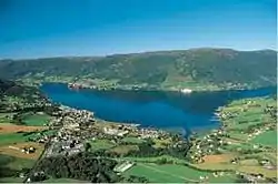 View of the municipal centre of Ølensjøen | |
 Rogaland within Norway | |
 Vindafjord within Rogaland | |
| Coordinates: 59°32′44″N 05°49′05″E | |
| Country | Norway |
| County | Rogaland |
| District | Haugaland |
| Established | 1 Jan 1965 |
| Administrative centre | Ølensjøen |
| Government | |
| • Mayor (2011) | Ole Johan Vierdal (Sp) |
| Area | |
| • Total | 620.59 km2 (239.61 sq mi) |
| • Land | 598.73 km2 (231.17 sq mi) |
| • Water | 21.86 km2 (8.44 sq mi) 3.5% |
| Area rank | 186 in Norway |
| Population (2020) | |
| • Total | 8,714 |
| • Rank | 123 in Norway |
| • Density | 14.6/km2 (38/sq mi) |
| • Change (10 years) | 6.3% |
| Demonym(s) | Vindafjording[1] |
| Time zone | UTC+01:00 (CET) |
| • Summer (DST) | UTC+02:00 (CEST) |
| ISO 3166 code | NO-1160 |
| Official language form | Nynorsk[2] |
| Website | vindafjord |
The 621-square-kilometre (240 sq mi) municipality is the 186th largest by area out of the 356 municipalities in Norway. Vindafjord is the 123rd most populous municipality in Norway with a population of 8,714. The municipality's population density is 14.6 inhabitants per square kilometre (38/sq mi) and its population has increased by 6.3% over the previous 10-year period.[3][4]
General information
During the 1960s, there were many municipal mergers across Norway due to the work of the Schei Committee. On 1 January 1965, the new municipality of Vindafjord was created from several areas in northern Rogaland county:
- all of Sandeid municipality (population: 876)
- the Liarheim og Langeland areas of Skjold municipality on the north side of the Skjoldafjorden (population: 1,262)
- all of Vats municipality except for the Breidal and Stølsvik farms (population: 1,128)
- all of Imsland municipality located north of the Vindafjorden (population: 372)
- all of Vikedal municipality except for the Hapnes and Dokskar farms (population: 978)
Initially, Vindafjord had 4,616 residents. On 1 January 1969, the Sponevik farm (population: 6) was transferred from Vindafjord to the neighboring municipality of Tysvær. Then on 1 January 1978, the Vormestrand area along the southern shore of the Vindafjorden (population: 13) was transferred to neighboring Suldal municipality.[5]
On 1 January 2006, Vindafjord merged with the neighboring municipality of Ølen (population: 3,420). Ølen had transferred from Hordaland county to Rogaland county 2002. After the merger, the municipal centre of Vindafjord was moved from Sandeid to the village of Ølensjøen, which had been the administrative centre of Ølen.[6]
Name
The municipality (created in 1965) is named after the Vindafjorden, a fjord that runs through the eastern part of the municipality. The first element is probably derived from the verb vinda which means "turn" or "twist" referring to the sharp turn of the fjord at Dragneset.[7]
Coat of arms
The coat of arms were granted on 10 March 2006, shortly after the merger of Ølen with Vindafjord. The new arms are a mix of the old arms of the two municipalities before the merger. The swirling design is taken from the old coat-of-arms of Ølen and the colours (red and silver/white) are from the old arms of Vindafjord. The swirling design of the arms show in a symbolized way all the roads that come together in the municipality. The municipality thus is an important centre of trade.[7][8]
 Current arms since 2006.
 Arms from 1986 until 2005.
 Arms of Ølen (used from 1986 to 2005 when it merged with Vindafjord)
Churches
The Church of Norway has eight parishes (sokn) within the municipality of Vindafjord. It is part of the Haugaland prosti (deanery) in the Diocese of Stavanger.
| Parish (sokn) | Church name | Location of the church | Year built |
|---|---|---|---|
| Bjoa | Bjoa Church | Bjoa | 1895 |
| Imsland | Imsland Church | Imslandsjøen | 1861 |
| Sandeid | Sandeid Church | Sandeid | 1904 |
| Skjold | Skjold Church | Skjold | 1999 |
| Vats | Vats Church | Vats | 1855 |
| Vikebygd | Vikebygd Church | Vikebygd | 1937 |
| Vikedal | Vikedal Church | Vikedal | 1881 |
| Ølen | Ølen Church | Ølensjøen | 1874 |
Government
All municipalities in Norway, including Vindafjord, are responsible for primary education (through 10th grade), outpatient health services, senior citizen services, unemployment and other social services, zoning, economic development, and municipal roads. The municipality is governed by a municipal council of elected representatives, which in turn elect a mayor.[9] The municipality falls under the Haugaland District Court and the Gulating Court of Appeal.
Municipal council
The municipal council (Kommunestyre) of Vindafjord is made up of 25 representatives that are elected to four year terms. Currently, the party breakdown is as follows:
| Party Name (in Nynorsk) | Number of representatives | |
|---|---|---|
| Labour Party (Arbeidarpartiet) | 3 | |
| Progress Party (Framstegspartiet) | 2 | |
| Green Party (Miljøpartiet Dei Grøne) | 1 | |
| Conservative Party (Høgre) | 5 | |
| Christian Democratic Party (Kristeleg Folkeparti) | 3 | |
| Centre Party (Senterpartiet) | 9 | |
| Socialist Left Party (Sosialistisk Venstreparti) | 1 | |
| Bjoa local list (Bjoa bygdeliste) | 1 | |
| Total number of members: | 25 | |
| Party Name (in Nynorsk) | Number of representatives | |
|---|---|---|
| Labour Party (Arbeidarpartiet) | 3 | |
| Progress Party (Framstegspartiet) | 2 | |
| Conservative Party (Høgre) | 3 | |
| Christian Democratic Party (Kristeleg Folkeparti) | 3 | |
| Centre Party (Senterpartiet) | 10 | |
| Socialist Left Party (Sosialistisk Venstreparti) | 1 | |
| Liberal Party (Venstre) | 2 | |
| Bjoa local list (Bjoa bygdeliste) | 1 | |
| Total number of members: | 25 | |
| Party Name (in Nynorsk) | Number of representatives | |
|---|---|---|
| Labour Party (Arbeidarpartiet) | 4 | |
| Progress Party (Framstegspartiet) | 3 | |
| Conservative Party (Høgre) | 5 | |
| Christian Democratic Party (Kristeleg Folkeparti) | 3 | |
| Centre Party (Senterpartiet) | 8 | |
| Socialist Left Party (Sosialistisk Venstreparti) | 1 | |
| Bjoa local list (Bjoa bygdeliste) | 1 | |
| Total number of members: | 25 | |
| Party Name (in Nynorsk) | Number of representatives | |
|---|---|---|
| Labour Party (Arbeidarpartiet) | 5 | |
| Progress Party (Framstegspartiet) | 3 | |
| Conservative Party (Høgre) | 4 | |
| Christian Democratic Party (Kristeleg Folkeparti) | 3 | |
| Centre Party (Senterpartiet) | 9 | |
| Bjoa local list (Bjoa bygdeliste) | 1 | |
| Total number of members: | 25 | |
| Party Name (in Nynorsk) | Number of representatives | |
|---|---|---|
| Labour Party (Arbeidarpartiet) | 4 | |
| Conservative Party (Høgre) | 4 | |
| Christian Democratic Party (Kristeleg Folkeparti) | 2 | |
| Centre Party (Senterpartiet) | 6 | |
| Skold and Vats cross-party list (Skjold og Vats tverrpolitisk liste) | 3 | |
| Total number of members: | 19 | |
| Party Name (in Nynorsk) | Number of representatives | |
|---|---|---|
| Labour Party (Arbeidarpartiet) | 4 | |
| Conservative Party (Høgre) | 4 | |
| Christian Democratic Party (Kristeleg Folkeparti) | 4 | |
| Centre Party (Senterpartiet) | 6 | |
| Vikedal and Imsland local list (Vikedal og Imsland bygdeliste) | 2 | |
| Cross-party list for Skjold/Vats and Sandeid/Ilsvåg (Tverrpolitisk liste for Skjold/Vats og Sandeid/Ilsvåg) | 9 | |
| Total number of members: | 29 | |
| Party Name (in Nynorsk) | Number of representatives | |
|---|---|---|
| Labour Party (Arbeidarpartiet) | 3 | |
| Conservative Party (Høgre) | 3 | |
| Christian Democratic Party (Kristeleg Folkeparti) | 4 | |
| Centre Party (Senterpartiet) | 10 | |
| Vikedal and Imsland local list (Skjold og Vats bygdeliste) | 6 | |
| Sandeid and Ilsvåg local list (Sandeid og Ilsvåg bygdeliste) | 3 | |
| Total number of members: | 29 | |
| Party Name (in Nynorsk) | Number of representatives | |
|---|---|---|
| Labour Party (Arbeidarpartiet) | 2 | |
| Conservative Party (Høgre) | 3 | |
| Christian Democratic Party (Kristeleg Folkeparti) | 3 | |
| Centre Party (Senterpartiet) | 8 | |
| Skjold and Vats local list (Skjold og Vats bygdeliste) | 8 | |
| Sandeid and Ilsvåg local list (Sandeid og Ilsvåg bygdeliste) | 3 | |
| Local list for Skjold (Bygdeliste for Skjold) | 1 | |
| Left wind (Venstrevind) | 1 | |
| Total number of members: | 29 | |
| Party Name (in Nynorsk) | Number of representatives | |
|---|---|---|
| Labour Party (Arbeidarpartiet) | 2 | |
| Conservative Party (Høgre) | 3 | |
| Christian Democratic Party (Kristeleg Folkeparti) | 2 | |
| Skjold and Vats local list (Skjold og Vats bygdeliste) | 11 | |
| Sandeid and Ilsvåg local list (Sandeid og Ilsvåg bygdeliste) | 4 | |
| Vikedal and Imsland local list (Vikedal og Imsland bygdeliste) | 6 | |
| Left wind (Venstrevind) | 1 | |
| Total number of members: | 29 | |
| Party Name (in Nynorsk) | Number of representatives | |
|---|---|---|
| Labour Party (Arbeidarpartiet) | 4 | |
| Conservative Party (Høgre) | 6 | |
| Christian Democratic Party (Kristeleg Folkeparti) | 5 | |
| Centre Party (Senterpartiet) | 10 | |
| Sandeid and Ilsvåg local list (Sandeid og Ilsvåg bygdeliste) | 3 | |
| Left wind (Venstrevind) | 1 | |
| Total number of members: | 29 | |
| Party Name (in Nynorsk) | Number of representatives | |
|---|---|---|
| Labour Party (Arbeidarpartiet) | 2 | |
| Conservative Party (Høgre) | 7 | |
| Christian Democratic Party (Kristeleg Folkeparti) | 5 | |
| Centre Party (Senterpartiet) | 8 | |
| Vindafjord non-partisan women's list (Vindafjord upolitisk kvinneliste) | 1 | |
| Sandeid and Ilsvåg local list (Sandeid og Ilsvåg bygdeliste) | 3 | |
| Vikedal and Imsland local list (Vikedal og Imsland bygdeliste) | 3 | |
| Total number of members: | 29 | |
| Party Name (in Nynorsk) | Number of representatives | |
|---|---|---|
| Labour Party (Arbeidarpartiet) | 3 | |
| Conservative Party (Høgre) | 6 | |
| Christian Democratic Party (Kristeleg Folkeparti) | 6 | |
| Centre Party (Senterpartiet) | 11 | |
| Skjold local list (Skjold Bygdeliste) | 1 | |
| Non-partisan list for Skjold and Vats (Upolitisk liste for Skjold og Vats) | 2 | |
| Total number of members: | 29 | |
| Party Name (in Nynorsk) | Number of representatives | |
|---|---|---|
| Labour Party (Arbeidarpartiet) | 2 | |
| Local List(s) (Lokale lister) | 27 | |
| Total number of members: | 29 | |
| Party Name (in Nynorsk) | Number of representatives | |
|---|---|---|
| Labour Party (Arbeidarpartiet) | 2 | |
| Christian Democratic Party (Kristeleg Folkeparti) | 4 | |
| Local List(s) (Lokale lister) | 23 | |
| Total number of members: | 29 | |
Geography
The municipality of Vindafjord lies south of the Hardangerfjorden and north of the Skjoldafjorden and Vindafjorden. The Sandeidfjorden flows through the municipality also. The lake Vatsvatnet lies in the central part of the municipality. The municipality sits near the base of the Haugalandet peninsula, connecting the mainland to the city of Haugesund on the western end of the peninsula. The European route E134 highway runs through the municipality.
Notable people
- Knud Baade (1808 in Skjold - 1879) a Norwegian painter of portraits and landscapes, particularly moonlight paintings
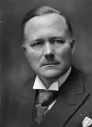
- Jens Hundseid (1883 in Vikedal – 1965) a Norwegian politician, Prime Minister of Norway 1932 to 1933; joined Nasjonal Samling in 1940
- Thormod Næs (1930 in Skjold – 1997) a sport shooter, competed at the 1964 Summer Olympics
- Per Øyvind Heradstveit (1932 in Skjold – 2004) a Norwegian TV journalist and non-fiction writer
- Agnes Ravatn (born 1983 in Ølen) a Norwegian novelist, columnist and journalist
References
- "Navn på steder og personer: Innbyggjarnamn" (in Norwegian). Språkrådet.
- "Forskrift om målvedtak i kommunar og fylkeskommunar" (in Norwegian). Lovdata.no.
- Statistisk sentralbyrå (2020). "Table: 06913: Population 1 January and population changes during the calendar year (M)" (in Norwegian).
- Statistisk sentralbyrå (2020). "09280: Area of land and fresh water (km²) (M)" (in Norwegian).
- Jukvam, Dag (1999). "Historisk oversikt over endringer i kommune- og fylkesinndelingen" (PDF) (in Norwegian). Statistisk sentralbyrå.
- Store norske leksikon. "Ølen" (in Norwegian). Retrieved 19 August 2015.
- Store norske leksikon. "Vindafjord" (in Norwegian). Retrieved 19 August 2015.
- "Civic heraldry of Norway - Norske Kommunevåpen". Heraldry of the World. Retrieved 19 August 2015.
- Hansen, Tore, ed. (12 May 2016). "kommunestyre". Store norske leksikon (in Norwegian). Kunnskapsforlaget. Retrieved 28 June 2020.
- "Tall for Norge: Kommunestyrevalg 2019 - Rogaland". Valg Direktoratet. Retrieved 2 July 2020.
- "Table: 04813: Members of the local councils, by party/electoral list at the Municipal Council election (M)" (in Norwegian). Statistics Norway.
- "Tall for Norge: Kommunestyrevalg 2011 - Rogaland". Valg Direktoratet. Retrieved 2 July 2020.
- "Kommunestyrevalget 1995" (PDF) (in Norwegian). Oslo-Kongsvinger: Statistisk sentralbyrå. 1996. Retrieved 2 July 2020.
- "Kommunestyrevalget 1991" (PDF) (in Norwegian). Oslo-Kongsvinger: Statistisk sentralbyrå. 1993. Retrieved 2 July 2020.
- "Kommunestyrevalget 1987" (PDF) (in Norwegian). Oslo-Kongsvinger: Statistisk sentralbyrå. 1988. Retrieved 2 July 2020.
- "Kommunestyrevalget 1983" (PDF) (in Norwegian). Oslo-Kongsvinger: Statistisk sentralbyrå. 1984. Retrieved 2 July 2020.
- "Kommunestyrevalget 1979" (PDF) (in Norwegian). Oslo: Statistisk sentralbyrå. 1979. Retrieved 2 July 2020.
- "Kommunevalgene 1975" (PDF) (in Norwegian). Oslo: Statistisk sentralbyrå. 1977. Retrieved 2 July 2020.
- "Kommunevalgene 1972" (PDF) (in Norwegian). Oslo: Statistisk sentralbyrå. 1973. Retrieved 2 July 2020.
- "Kommunevalgene 1967" (PDF) (in Norwegian). Oslo: Statistisk sentralbyrå. 1967. Retrieved 2 July 2020.
External links
- Municipal fact sheet from Statistics Norway (in Norwegian)
 Media related to Vindafjord at Wikimedia Commons
 The dictionary definition of Vindafjord at Wiktionary
 Rogaland travel guide from Wikivoyage
 |
|  | |||||||||||||||||||||||||
||