Halbe
Halbe (Lower Sorbian Łobje) is a municipality in the Dahme-Spreewald district of Brandenburg, Germany. It is situated near the capital city Berlin and the Spreewald. Four other villages are part of Halbe: Briesen/Brand with the Tropical Islands resorts of Dom, Teurow, Freidorf and Oderin. Halbe was the site of the Battle of Halbe during the final days of the Second World War.
Halbe | |
|---|---|
 Coat of arms | |
Location of Halbe within Dahme-Spreewald district 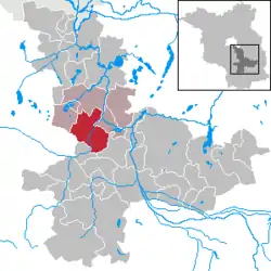 | |
 Halbe  Halbe | |
| Coordinates: 52°6′31″N 13°42′3″E | |
| Country | Germany |
| State | Brandenburg |
| District | Dahme-Spreewald |
| Municipal assoc. | Schenkenländchen |
| Subdivisions | 3 Ortsteile und 4 Gemeindeteile |
| Government | |
| • Mayor | Ralf Kunze (Ind.) |
| Area | |
| • Total | 78.08 km2 (30.15 sq mi) |
| Elevation | 35 m (115 ft) |
| Population (2019-12-31)[1] | |
| • Total | 2,331 |
| • Density | 30/km2 (77/sq mi) |
| Time zone | UTC+01:00 (CET) |
| • Summer (DST) | UTC+02:00 (CEST) |
| Postal codes | 15757 |
| Dialling codes | 033765 |
| Vehicle registration | LDS |
| Website | gemeinde-halbe.de |
Demography
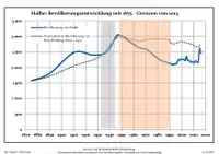
Development of population since 1875 within the current boundaries (Blue line: Population; Dotted line: Comparison to population development of Brandenburg state; Grey background: Time of Nazi rule; Red background: Time of communist rule)
|
|
|
See also
- The Battle of Halbe, which was fought in the last days of the Second World War.
- The Kaiserbahnhof Halbe, which was built for Kaiser Wilhelm I
References
- "Bevölkerung im Land Brandenburg nach amtsfreien Gemeinden, Ämtern und Gemeinden 31. Dezember 2019". Amt für Statistik Berlin-Brandenburg (in German). July 2020.
- Detailed data sources are to be found in the Wikimedia Commons.Population Projection Brandenburg at Wikimedia Commons
| Authority control |
|---|
This article is issued from Wikipedia. The text is licensed under Creative Commons - Attribution - Sharealike. Additional terms may apply for the media files.
