Märkisch Buchholz
Märkisch Buchholz is a small town in the Dahme-Spreewald district, in Brandenburg, Germany. It is situated on the Dahme River, 20 km northwest of Lübben (Spreewald) and resp. 50 km southeast of Berlin.
Märkisch Buchholz | |
|---|---|
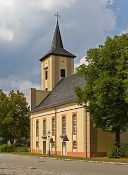 Church | |
 Coat of arms | |
Location of Märkisch Buchholz within Dahme-Spreewald district  | |
 Märkisch Buchholz  Märkisch Buchholz | |
| Coordinates: 52°06′N 13°45′E | |
| Country | Germany |
| State | Brandenburg |
| District | Dahme-Spreewald |
| Municipal assoc. | Schenkenländchen |
| Subdivisions | 3 Ortsteile |
| Government | |
| • Mayor | Bianca Urban (FW) |
| Area | |
| • Total | 24.65 km2 (9.52 sq mi) |
| Elevation | 42 m (138 ft) |
| Population (2019-12-31)[1] | |
| • Total | 830 |
| • Density | 34/km2 (87/sq mi) |
| Time zone | UTC+01:00 (CET) |
| • Summer (DST) | UTC+02:00 (CEST) |
| Postal codes | 15748 |
| Dialling codes | 033765 |
| Vehicle registration | LDS |
| Website | www.maerkischbuchholz.de |
Overview
The town is the smallest one in Brandenburg with town status. Founded in the 12th or 13th century the town's first historical mention dated on 13 August 1301, described as castrum et oppidum Buchholt. The town was heavily destroyed during the last day of World War II, due to strategic position at the Dahme river in Battle of Halbe. The federal highway B179 connect the town direct with Berlin.
Demography
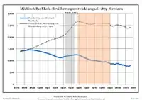
Development of population since 1875 within the current boundaries (Blue line: Population; Dotted line: Comparison to population development of Brandenburg state; Grey background: Time of Nazi rule; Red background: Time of communist rule)
|
|
|
See also
References
- "Bevölkerung im Land Brandenburg nach amtsfreien Gemeinden, Ämtern und Gemeinden 31. Dezember 2019". Amt für Statistik Berlin-Brandenburg (in German). July 2020.
- Detailed data sources are to be found in the Wikimedia Commons.Population Projection Brandenburg at Wikimedia Commons
 Märkisch Buchholz travel guide from Wikivoyage
| Authority control |
|---|
This article is issued from Wikipedia. The text is licensed under Creative Commons - Attribution - Sharealike. Additional terms may apply for the media files.