Krausnick-Groß Wasserburg
Krausnick-Groß Wasserburg (Lower sorbian: Kšušwica-Wódowy Grod) is a municipality in the district of Dahme-Spreewald in Brandenburg in Germany.
Krausnick-Groß Wasserburg | |
|---|---|
Location of Krausnick-Groß Wasserburg within Dahme-Spreewald district 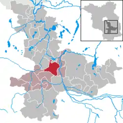 | |
 Krausnick-Groß Wasserburg  Krausnick-Groß Wasserburg | |
| Coordinates: 52°02′00″N 13°51′00″E | |
| Country | Germany |
| State | Brandenburg |
| District | Dahme-Spreewald |
| Municipal assoc. | Unterspreewald |
| Government | |
| • Mayor | Toni Schoan |
| Area | |
| • Total | 54.54 km2 (21.06 sq mi) |
| Elevation | 50 m (160 ft) |
| Population (2019-12-31)[1] | |
| • Total | 582 |
| • Density | 11/km2 (28/sq mi) |
| Time zone | UTC+01:00 (CET) |
| • Summer (DST) | UTC+02:00 (CEST) |
| Postal codes | 15910 |
| Dialling codes | 035472, 035473 |
| Vehicle registration | LDS |
| Website | www.unterspreewald.de |
Geography
In the middle of the heavily wooded municipality of Krausnick-Groß Wasserburg rise the Krausnick hills (also called the Bergspreewald or Bergspree Woods), which reach a maximum elevation of 144 m above sea level at the summit of the Wehlaberg, and rise about 100 metres above the adjacent Lower Spreewald woods. In the north of the area (in Groß Wasserburg) the Rand Canal branches off the River Spree (Wasserburger Spree) and runs along the Baruth Urstromtal to the Köthener See, which is linked to the River Dahme by the Dahme Flood Relief Canal. The municipality lies ca. 60 km southeast of Berlin.
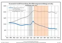
Demography
|
|
|
|
Detailed data sources are to be found in the Wikimedia Commons.[3]
See also
References
- "Bevölkerung im Land Brandenburg nach amtsfreien Gemeinden, Ämtern und Gemeinden 31. Dezember 2019". Amt für Statistik Berlin-Brandenburg (in German). July 2020.
- Boundaries as of 2013
- Population Projection Brandenburg at Wikimedia Commons