Hampton Township, New Jersey
Hampton Township is a township in Sussex County, New Jersey, United States. As of the 2010 United States Census, the township's population was 5,196,[7][8][9] reflecting an increase of 253 (+5.1%) from the 4,943 counted in the 2000 Census, which had in turn increased by 505 (+11.4%) from the 4,438 counted in the 1990 Census.[17]
- See Hampton, New Jersey for the borough in Hunterdon County.
Hampton Township, New Jersey | |
|---|---|
| Township of Hampton | |
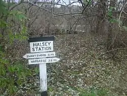 Halsey Station | |
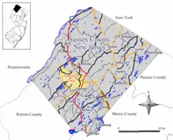 Map of Hampton Township in Sussex County. Inset: Location of Sussex County highlighted in the State of New Jersey. | |
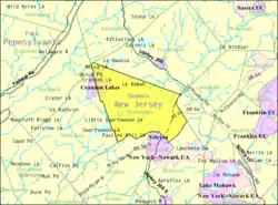 Census Bureau map of Hampton Township, New Jersey | |
 Hampton Township Location in Sussex County  Hampton Township Location in New Jersey  Hampton Township Location in the United States | |
| Coordinates: 41.091701°N 74.789608°W[1][2] | |
| Country | |
| State | |
| County | |
| Incorporated | April 11, 1864 |
| Named for | Jonathan Hampton |
| Government | |
| • Type | Township |
| • Body | Township Committee |
| • Mayor | Philip L. Yetter (R, term ends December 31, 2020)[4][5] |
| • Administrator | Jessica Caruso[4] |
| • Municipal clerk | Kathleen Armstrong[4] |
| Area | |
| • Total | 25.48 sq mi (66.00 km2) |
| • Land | 24.57 sq mi (63.63 km2) |
| • Water | 0.91 sq mi (2.36 km2) 3.58% |
| Area rank | 104th of 565 in state 9th of 24 in county[1] |
| Elevation | 594 ft (181 m) |
| Population | |
| • Total | 5,196 |
| • Estimate (2019)[10] | 4,842 |
| • Rank | 370th of 566 in state 10th of 24 in county[11] |
| • Density | 213.2/sq mi (82.3/km2) |
| • Density rank | 500th of 566 in state 16th of 24 in county[11] |
| Time zone | UTC−05:00 (Eastern (EST)) |
| • Summer (DST) | UTC−04:00 (Eastern (EDT)) |
| ZIP Code | 07860 - Newton, New Jersey[12] |
| Area code(s) | 973[13] |
| FIPS code | 3403729490[1][14][15] |
| GNIS feature ID | 0882261[1][16] |
| Website | www |
Hampton Township was formed from portions of Sussex County by an act of the New Jersey Legislature on April 11, 1864.[18] The township was named for Jonathan Hampton, who donated land in 1769 to the Episcopal Church of Newton.[19] State legislator Robert Hamilton, an Episcopalian, appreciated Hampton's generosity, and gave the township its name.[20] Portions of the township were taken on February 24, 1904, to form Fredon Township.[18]
Geography
According to the United States Census Bureau, Hampton township had a total area of 25.48 square miles (66.00 km2), including 24.57 square miles (63.63 km2) of land and 0.91 square miles (2.36 km2) of water (3.58%).[1][2] The township is located in the Kittatinny Valley, a section of the Great Appalachian Valley that stretches 700 miles (1,100 km) from Canada to Alabama.
Crandon Lakes (with a 2010 Census population of 682 in Hampton Township, out of a CDP total of 1,178[21]) is an unincorporated community and census-designated place (CDP) split between Hampton Township and Stillwater Township.[22][23][24] Other unincorporated communities, localities and place names located partially or completely within the township include Balesville, Emmons Station, Halsey, Lake Kemah, Little Swartswood Lake, Mecca Lake, Myrtle Grove, Paulins Kill Lake, Smiths Hill, Spring Lake and Washingtonville.[25]
Smiths Hill is a hill located at 41.0825969°N 74.7468316°W in the Kittatinny Valley of the Appalachian Mountains. The summit rises to 863 feet (263 m).[26]
The township borders the Sussex County municipalities of Frankford Township, Fredon Township, Lafayette Township, Newton and Stillwater Township.[27][28]
Demographics
| Historical population | |||
|---|---|---|---|
| Census | Pop. | %± | |
| 1870 | 1,023 | — | |
| 1880 | 895 | −12.5% | |
| 1890 | 866 | −3.2% | |
| 1900 | 775 | −10.5% | |
| 1910 | 671 | * | −13.4% |
| 1920 | 592 | −11.8% | |
| 1930 | 581 | −1.9% | |
| 1940 | 611 | 5.2% | |
| 1950 | 668 | 9.3% | |
| 1960 | 1,174 | 75.7% | |
| 1970 | 2,091 | 78.1% | |
| 1980 | 3,916 | 87.3% | |
| 1990 | 4,438 | 13.3% | |
| 2000 | 4,943 | 11.4% | |
| 2010 | 5,196 | 5.1% | |
| 2019 (est.) | 4,842 | [10][29] | −6.8% |
| Population sources: 1870-1920[30] 1870[31][32] 1880-1890[33] 1890-1910[34] 1910-1930[35] 1930-1990[36] 2000[37][38] 2010[7][8][9] * = Lost territory in previous decade.[18] | |||
Census 2010
The 2010 United States Census counted 5,196 people, 2,021 households, and 1,445 families in the township. The population density was 213.2 per square mile (82.3/km2). There were 2,200 housing units at an average density of 90.3 per square mile (34.9/km2). The racial makeup was 96.44% (5,011) White, 0.83% (43) Black or African American, 0.08% (4) Native American, 1.19% (62) Asian, 0.02% (1) Pacific Islander, 0.44% (23) from other races, and 1.00% (52) from two or more races. Hispanic or Latino of any race were 3.85% (200) of the population.[7]
Of the 2,021 households, 28.1% had children under the age of 18; 60.0% were married couples living together; 8.3% had a female householder with no husband present and 28.5% were non-families. Of all households, 23.6% were made up of individuals and 9.6% had someone living alone who was 65 years of age or older. The average household size was 2.55 and the average family size was 3.03.[7]
21.0% of the population were under the age of 18, 7.7% from 18 to 24, 21.3% from 25 to 44, 35.1% from 45 to 64, and 14.8% who were 65 years of age or older. The median age was 44.9 years. For every 100 females, the population had 95.8 males. For every 100 females ages 18 and older there were 93.9 males.[7]
The Census Bureau's 2006-2010 American Community Survey showed that (in 2010 inflation-adjusted dollars) median household income was $77,639 (with a margin of error of +/- $5,453) and the median family income was $86,795 (+/- $7,981). Males had a median income of $63,168 (+/- $9,682) versus $37,682 (+/- $3,054) for females. The per capita income for the borough was $32,953 (+/- $3,286). About 3.0% of families and 7.1% of the population were below the poverty line, including 4.4% of those under age 18 and 6.1% of those age 65 or over.[39]
Census 2000
As of the 2000 United States Census[14] there were 4,943 people, 1,857 households, and 1,413 families residing in the township. The population density was 200.7 people per square mile (77.5/km2). There were 2,026 housing units at an average density of 82.3 per square mile (31.8/km2). The racial makeup of the township was 97.29% White, 0.97% African American, 0.02% Native American, 0.67% Asian, 0.02% Pacific Islander, 0.30% from other races, and 0.73% from two or more races. 1.90% of the population were Hispanic or Latino of any race.[37][38]
There were 1,857 households, out of which 36.9% had children under the age of 18 living with them, 64.2% were married couples living together, 8.9% had a female householder with no husband present, and 23.9% were non-families. 20.7% of all households were made up of individuals, and 7.7% had someone living alone who was 65 years of age or older. The average household size was 2.65 and the average family size was 3.10.[37][38]
In the township the population was spread out, with 26.5% under the age of 18, 5.5% from 18 to 24, 28.5% from 25 to 44, 28.4% from 45 to 64, and 11.1% who were 65 years of age or older. The median age was 40 years. For every 100 females, there were 95.4 males. For every 100 females age 18 and over, there were 91.3 males.[37][38]
The median income for a household in the township was $60,698, and the median income for a family was $67,386. Males had a median income of $48,882 versus $36,500 for females. The per capita income for the township was $25,353. 2.0% of the population and 1.2% of families were below the poverty line. Out of the total population, 2.0% of those under the age of 18 and 2.2% of those 65 and older were living below the poverty line.[37][38]
Government
Local government
Hampton Township is governed under the Township form of New Jersey municipal government, one of 141 municipalities (of the 565) statewide that use this form, the second-most commonly used form of government in the state.[40] The Township Committee is comprised of five members, who are elected directly by the voters at-large in partisan elections to serve three-year terms of office on a staggered basis, with either one or two seats coming up for election each year as part of the November general election in a three-year cycle.[3][41] At an annual reorganization meeting, the Township Committee selects one of its members to serve as Mayor.
As of 2020, members of the Hampton Township Committee are Mayor Philip L. Yetter (R, term on committee and as mayor ends December 31, 2020), Timothy S. Dooley (R, 2021), Keith Gourlay (R, 2021), David S. Hansen (R, 2020) and Eileen Klose (R, 2022).[4][42][43][44][45]
In January 2015, the township committee selected Scott MacKenzie to fill the vacant seat of Keith Gourlay expiring in December 2016.[46] MacKenzie served on an interim basis until the November 2015 general election, when he was elected to serve the one year remaining on the term of office, while Keith Gourlay—who had left office earlier—was elected to a term expiring in December 2018.[47]
Federal, state and county representation
Hampton Township is located in the 5th Congressional District[48] and is part of New Jersey's 24th state legislative district.[8][49][50]
For the 116th United States Congress, New Jersey's Fifth Congressional District is represented by Josh Gottheimer (D, Wyckoff).[51][52] New Jersey is represented in the United States Senate by Democrats Cory Booker (Newark, term ends 2021)[53] and Bob Menendez (Paramus, term ends 2025).[54][55]
For the 2018–2019 session (Senate, General Assembly), the 24th Legislative District of the New Jersey Legislature is represented in the State Senate by Steve Oroho (R, Franklin) and in the General Assembly by Parker Space (R, Wantage Township) and Harold J. Wirths (R, Hardyston Township).[56][57]
Sussex County is governed by a Board of Chosen Freeholders whose five members are elected at-large in partisan elections on a staggered basis, with either one or two seats coming up for election each year. At an annual reorganization meeting held in the beginning of January, the board selects a Freeholder Director and Deputy Director from among its members, with day-to-day supervision of the operation of the county delegated to a County Administrator.[58] As of 2014, Sussex County's Freeholders are Freeholder Director Richard Vohden (R, Green Township, 2016),[59] Deputy Director Dennis J. Mudrick (R, Sparta Township, 2015),[60] Phillip R. Crabb (R, Franklin, 2014),[61] George Graham (R, Stanhope, 2016)[62] and Gail Phoebus (R, Andover Township, 2015).[63][58] Graham was chosen in April 2013 to fill the seat vacated by Parker Space, who had been chosen to fill a vacancy in the New Jersey General Assembly.[64] Constitutional officers elected on a countywide basis are County Clerk Jeff Parrott (R, 2016),[65] Sheriff Michael F. Strada (R, 2016)[66] and Surrogate Gary R. Chiusano (R, filling the vacancy after the resignation of Nancy Fitzgibbons).[67][64] The County Administrator is John Eskilson.[68][69]
Politics
As of March 23, 2011, there were a total of 3,600 registered voters in Hampton Township, of which 615 (17.1% vs. 16.5% countywide) were registered as Democrats, 1,565 (43.5% vs. 39.3%) were registered as Republicans and 1,418 (39.4% vs. 44.1%) were registered as Unaffiliated. There were 2 voters registered to other parties.[70] Among the township's 2010 Census population, 69.3% (vs. 65.8% in Sussex County) were registered to vote, including 87.7% of those ages 18 and over (vs. 86.5% countywide).[70][71]
In the 2012 presidential election, Republican Mitt Romney received 1,479 votes (58.3% vs. 59.4% countywide), ahead of Democrat Barack Obama with 989 votes (39.0% vs. 38.2%) and other candidates with 55 votes (2.2% vs. 2.1%), among the 2,535 ballots cast by the township's 3,676 registered voters, for a turnout of 69.0% (vs. 68.3% in Sussex County).[72] In the 2008 presidential election, Republican John McCain received 1,636 votes (58.3% vs. 59.2% countywide), ahead of Democrat Barack Obama with 1,109 votes (39.6% vs. 38.7%) and other candidates with 32 votes (1.1% vs. 1.5%), among the 2,804 ballots cast by the township's 3,517 registered voters, for a turnout of 79.7% (vs. 76.9% in Sussex County).[73] In the 2004 presidential election, Republican George W. Bush received 1,641 votes (63.6% vs. 63.9% countywide), ahead of Democrat John Kerry with 887 votes (34.4% vs. 34.4%) and other candidates with 45 votes (1.7% vs. 1.3%), among the 2,579 ballots cast by the township's 3,257 registered voters, for a turnout of 79.2% (vs. 77.7% in the whole county).[74]
In the 2013 gubernatorial election, Republican Chris Christie received 71.7% of the vote (1,100 cast), ahead of Democrat Barbara Buono with 25.1% (385 votes), and other candidates with 3.3% (50 votes), among the 1,550 ballots cast by the township's 3,684 registered voters (15 ballots were spoiled), for a turnout of 42.1%.[75][76] In the 2009 gubernatorial election, Republican Chris Christie received 1,226 votes (61.9% vs. 63.3% countywide), ahead of Democrat Jon Corzine with 538 votes (27.1% vs. 25.7%), Independent Chris Daggett with 184 votes (9.3% vs. 9.1%) and other candidates with 21 votes (1.1% vs. 1.3%), among the 1,982 ballots cast by the township's 3,547 registered voters, yielding a 55.9% turnout (vs. 52.3% in the county).[77]
Education
The Hampton Township School District serves students in kindergarten through sixth grade public school at McKeown School. As of the 2018–19 school year, the district, comprised of one school, had an enrollment of 286 students and 38.1 classroom teachers (on an FTE basis), for a student–teacher ratio of 7.5:1.[78]
Students in seventh through twelfth grade for public school attend Kittatinny Regional High School located in Hampton Township, which serves students who reside in Fredon Township, Hampton Township, Sandyston Township, Stillwater Township and Walpack Township.[79] The high school is located on a 96-acre (39 ha) campus in Hampton Township, about seven minutes outside of the county seat of Newton. As of the 2018–19 school year, the high school had an enrollment of 941 students and 97.5 classroom teachers (on an FTE basis), for a student–teacher ratio of 9.7:1.[80] Kittatinny Regional High School was recognized as a National Blue Ribbon School of Excellence in 1997–98.[81]
Transportation
_between_Park_Drive_and_Cherry_Lane_in_Hampton_Township%252C_Sussex_County%252C_New_Jersey.jpg.webp)
As of May 2010, the township had a total of 51.51 miles (82.90 km) of roadways, of which 25.99 miles (41.83 km) were maintained by the municipality, 21.24 miles (34.18 km) by Sussex County and 4.28 miles (6.89 km) by the New Jersey Department of Transportation.[82]
U.S. Route 206 is the primary highway serving Hampton Township. Much of the section of US 206 in Hampton Township is concurrent with New Jersey Route 94. Other significant roads traversing the township include County Route 519 and County Route 521.
References
- 2019 Census Gazetteer Files: New Jersey Places, United States Census Bureau. Accessed July 1, 2020.
- US Gazetteer files: 2010, 2000, and 1990, United States Census Bureau. Accessed September 4, 2014.
- 2012 New Jersey Legislative District Data Book, Rutgers University Edward J. Bloustein School of Planning and Public Policy, March 2013, p. 110.
- Township Committee, Hampton Township. Accessed April 13, 2020.
- 2020 New Jersey Mayors Directory, New Jersey Department of Community Affairs. Accessed February 1, 2020.
- U.S. Geological Survey Geographic Names Information System: Township of Hampton, Geographic Names Information System. Accessed March 5, 2013.
- DP-1 - Profile of General Population and Housing Characteristics: 2010 for Hampton township, Sussex County, New Jersey Archived 2020-02-12 at Archive.today, United States Census Bureau. Accessed February 20, 2013.
- Municipalities Sorted by 2011-2020 Legislative District, New Jersey Department of State. Accessed February 1, 2020.
- Profile of General Demographic Characteristics: 2010 for Hampton township Archived 2015-05-30 at the Wayback Machine, New Jersey Department of Labor and Workforce Development. Accessed February 20, 2013.
- Annual Estimates of the Resident Population for Minor Civil Divisions in New Jersey: April 1, 2010 to July 1, 2019, United States Census Bureau. Accessed May 21, 2020.
- GCT-PH1 Population, Housing Units, Area, and Density: 2010 - State -- County Subdivision from the 2010 Census Summary File 1 for New Jersey Archived 2020-02-12 at Archive.today, United States Census Bureau. Accessed February 20, 2013.
- Look Up a ZIP Code for Newton, NJ, United States Postal Service. Accessed February 20, 2013.
- Area Code Lookup - NPA NXX for Hampton, NJ, Area-Codes.com. Accessed January 18, 2015.
- U.S. Census website , United States Census Bureau. Accessed September 4, 2014.
- Geographic codes for New Jersey, Missouri Census Data Center. Accessed September 1, 2019.
- US Board on Geographic Names, United States Geological Survey. Accessed September 4, 2014.
- Table 7. Population for the Counties and Municipalities in New Jersey: 1990, 2000 and 2010, New Jersey Department of Labor and Workforce Development, February 2011. Accessed February 20, 2013.
- Snyder, John P. The Story of New Jersey's Civil Boundaries: 1606-1968, Bureau of Geology and Topography; Trenton, New Jersey; 1969. p. 230. Accessed February 20, 2013.
- Staff. "Hampton Township named for possible Loyalist" Archived 2016-03-04 at the Wayback Machine, KWWL (TV), May 31, 2012. Accessed August 31, 2015. "When Hampton Township was authorized by the state legislators on March 10, 1864, it acquired its name from Robert Hamilton, who named the newly formed township in honor of Capt. Jonathan Hampton.... In 1769, Hampton gave 27 acres of land to the Christ Episcopal Church in Newton for a rectory and parsonage."
- Snell, James P. (1881) History of Sussex and Warren Counties, New Jersey, With Illustrations and Biographical Sketches of Its Prominent Men and Pioneers. (Centennial ed., Harmony, NJ: Harmony Press, 1981) p. 454.
- DP-1 - Profile of General Population and Housing Characteristics: 2010 Demographic Profile Data for Crandon Lakes CDP, New Jersey Archived 2020-02-12 at Archive.today, United States Census Bureau. Accessed February 20, 2013.
- GCT-PH1 - Population, Housing Units, Area, and Density: 2010 - County -- County Subdivision and Place from the 2010 Census Summary File 1 for Sussex County, New Jersey Archived 2020-02-12 at Archive.today, United States Census Bureau. Accessed February 20, 2013.
- 2006-2010 American Community Survey Geography for New Jersey, United States Census Bureau. Accessed February 20, 2013.
- New Jersey: 2010 - Population and Housing Unit Counts - 2010 Census of Population and Housing (CPH-2-32), United States Census Bureau, August 2012. Accessed February 20, 2013.
- Locality Search, State of New Jersey. Accessed March 18, 2015.
- Smiths Hill, Geographic Names Information System. Accessed July 6, 2015.
- Sussex County Map, Sussex County, New Jersey. Accessed February 23, 2020.
- New Jersey Municipal Boundaries, New Jersey Department of Transportation. Accessed November 15, 2019.
- Census Estimates for New Jersey April 1, 2010 to July 1, 2019, United States Census Bureau. Accessed May 21, 2020.
- Compendium of censuses 1726-1905: together with the tabulated returns of 1905, New Jersey Department of State, 1906. Accessed September 10, 2013.
- Raum, John O. The History of New Jersey: From Its Earliest Settlement to the Present Time, Volume 1, p. 271, J. E. Potter and company, 1877. Accessed February 20, 2013. "Hampton contains a population of 1,023."
- Staff. A compendium of the ninth census, 1870, p. 261. United States Census Bureau, 1872. Accessed February 20, 2013.
- Porter, Robert Percival. Preliminary Results as Contained in the Eleventh Census Bulletins: Volume III - 51 to 75, p. 99. United States Census Bureau, 1890. Accessed February 20, 2013.
- Thirteenth Census of the United States, 1910: Population by Counties and Minor Civil Divisions, 1910, 1900, 1890, United States Census Bureau, p. 338. Accessed February 20, 2013.
- Fifteenth Census of the United States : 1930 - Population Volume I, United States Census Bureau, p. 719. Accessed February 20, 2013.
- Table 6. New Jersey Resident Population by Municipality: 1930 - 1990, New Jersey Department of Labor and Workforce Development. Accessed June 28, 2015.
- Census 2000 Profiles of Demographic / Social / Economic / Housing Characteristics for Hampton township, New Jersey Archived 2016-10-31 at the Wayback Machine, United States Census Bureau. Accessed October 31, 2016.
- DP-1: Profile of General Demographic Characteristics: 2000 - Census 2000 Summary File 1 (SF 1) 100-Percent Data for Hampton township, Sussex County, New Jersey Archived 2020-02-12 at Archive.today, United States Census Bureau. Accessed February 20, 2013.
- DP03: Selected Economic Characteristics from the 2006-2010 American Community Survey 5-Year Estimates for Hampton township, Sussex County, New Jersey Archived 2020-02-12 at Archive.today, United States Census Bureau. Accessed February 20, 2013.
- Inventory of Municipal Forms of Government in New Jersey, Rutgers University Center for Government Studies, July 1, 2011. Accessed November 18, 2019.
- "Forms of Municipal Government in New Jersey", p. 7. Rutgers University Center for Government Studies. Accessed June 3, 2015.
- 2019 Municipal User Friendly Budget, Hampton Township. Accessed April 13, 2020.
- Sussex County, New Jersey General Election November 5, 2019, Official Results Summary Report, Sussex County, New Jersey, dated November 8, 2019. Accessed January 1, 2020.
- Sussex County, New Jersey General Election November 6, 2018, Official Results Summary Report, Sussex County, New Jersey, dated November 9, 2018. Accessed January 1, 2019.
- Sussex County, New Jersey General Election November 7, 2017, Official Results Summary Report, Sussex County, New Jersey, dated November 9, 2017. Accessed January 1, 2018.
- Staff. "Assembly, freeholder top June primary races as candidates file" Archived 2015-06-23 at the Wayback Machine, KWWL (TV), March 30, 2015, updated May 31, 2015. Accessed June 23, 2015. "Republican Scott McKenzie filed petitions for the unexpired term (through Dec. 31, 2016) of Keith Gourlay. McKenzie was appointed to fill the vacancy on the committee pending the November election."
- Sussex County General Election November 3, 2015 Summary Report Official Results, Sussex County, New Jersey Clerk, updated November 6, 2015. Accessed August 1, 2016.
- Plan Components Report, New Jersey Redistricting Commission, December 23, 2011. Accessed February 1, 2020.
- 2019 New Jersey Citizen's Guide to Government, New Jersey League of Women Voters. Accessed October 30, 2019.
- Districts by Number for 2011-2020, New Jersey Legislature. Accessed January 6, 2013.
- Directory of Representatives: New Jersey, United States House of Representatives. Accessed January 3, 2019.
- Biography, Congressman Josh Gottheimer. Accessed January 3, 2019. "Josh now lives in Wyckoff, New Jersey with Marla, his wife who was a federal prosecutor, and their two young children, Ellie and Ben."
- About Cory Booker, United States Senate. Accessed January 26, 2015. "He now owns a home and lives in Newark's Central Ward community."
- Biography of Bob Menendez, United States Senate, January 26, 2015. "He currently lives in Paramus and has two children, Alicia and Robert."
- Senators of the 116th Congress from New Jersey. United States Senate. Accessed April 17, 2019. "Booker, Cory A. - (D - NJ) Class II; Menendez, Robert - (D - NJ) Class I"
- Legislative Roster 2018-2019 Session, New Jersey Legislature. Accessed January 22, 2018.
- District 24 Legislators, New Jersey Legislature. Accessed January 22, 2018.
- Sussex County Board of Chosen Freeholders, Sussex County, New Jersey. Accessed July 28, 2014.
- Richard A. Vohden, Sussex County, New Jersey. Accessed July 28, 2014.
- Dennis J. Mudrick, Sussex County, New Jersey. Accessed July 28, 2014.
- Phillip R. Crabb, Sussex County, New Jersey. Accessed July 28, 2014.
- George Graham, Sussex County, New Jersey. Accessed July 28, 2014.
- Gail Phoebus, Sussex County, New Jersey. Accessed July 28, 2014.
- Miller, Jennifer Jean. "George Graham Chosen as Freeholder at Sussex County Republican Convention", TheAlternativePress.com, April 13, 2013. Accessed April 25, 2013. "Graham will fill the freeholder seat that New Jersey Assemblyman Parker Space left to take his new position. Space recently took the seat, which formerly belonged to Gary Chiusano, who in turn, was appointed to the spot of Sussex County Surrogate, following the retirement of Surrogate Nancy Fitzgibbons."
- Home Page, Sussex County Clerk's Office. Accessed July 28, 2014.
- Sheriff's Office, Sussex County, New Jersey. Accessed July 28, 2014.
- Home Page, Sussex County Surrogate. Accessed July 28, 2014.
- County Administrator, Sussex County, New Jersey. Accessed July 28, 2014.
- Sussex County Official Directory 2014, Sussex County, New Jersey. Accessed July 28, 2014.
- Voter Registration Summary - Sussex, New Jersey Department of State Division of Elections, March 23, 2011. Accessed February 20, 2013.
- GCT-P7: Selected Age Groups: 2010 - State -- County Subdivision; 2010 Census Summary File 1 for New Jersey Archived 2020-02-12 at Archive.today, United States Census Bureau. Accessed February 20, 2013.
- General Election November 6, 2012: District Report - Group Detail Archived June 6, 2013, at the Wayback Machine, Sussex County, New Jersey Clerk, run date November 30, 2012. Accessed February 26, 2013.
- 2008 Presidential General Election Results: Sussex County, New Jersey Department of State Division of Elections, December 23, 2008. Accessed February 20, 2013.
- 2004 Presidential Election: Sussex County, New Jersey Department of State Division of Elections, December 13, 2004. Accessed February 20, 2013.
- "Governor - Sussex County" (PDF). New Jersey Department of Elections. January 29, 2014. Retrieved December 24, 2014.
- "Number of Registered Voters and Ballots Cast - November 5, 2013 - General Election Results - Sussex County" (PDF). New Jersey Department of Elections. January 29, 2014. Retrieved December 24, 2014.
- 2009 Governor: Sussex County Archived 2013-06-06 at the Wayback Machine, New Jersey Department of State Division of Elections, December 31, 2009. Accessed February 20, 2013.
- District information for Marian Mckeown School District, National Center for Education Statistics. Accessed April 1, 2020.
- Kittatiny Regional School District 2015 Report Card Narrative, New Jersey Department of Education. Accessed May 28, 2016. "Located in beautiful, rural Sussex County in northwest New Jersey, Kittatinny Regional School District serves the five municipalities of Fredon Township, Hampton Township, Sandyston Township, Stillwater Township and the Township of Walpack. The District is comprised of 125 square miles and has a school population of approximately 1100 students."
- School data for Kittatinny Regional High School, National Center for Education Statistics. Accessed April 1, 2020.
- Blue Ribbon Schools Program: Schools Recognized 1982-1983 through 1999-2002 (PDF), United States Department of Education. Accessed February 20, 2013.
- Sussex County Mileage by Municipality and Jurisdiction, New Jersey Department of Transportation, May 2010. Accessed July 18, 2014.
External links
| Wikimedia Commons has media related to Hampton Township, New Jersey. |
- Township website
- Hampton Township informational web pages
- Hampton Township School District - McKeown School
- Hampton Township School District's 2015–16 School Report Card from the New Jersey Department of Education
- School Data for the Hampton Township School District, National Center for Education Statistics
- Kittatinny Regional High School
- Hampton Township Volunteer Fire Department
Municipalities and communities of Sussex County, New Jersey, United States | ||
|---|---|---|
| Boroughs | 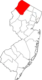 Map of New Jersey highlighting Sussex County | |
| Town | ||
| Townships | ||
| CDPs | ||
| Other unincorporated communities | ||
| ||