Sussex, New Jersey
Sussex is a borough in Sussex County, New Jersey, United States. As of the 2010 United States Census, the borough's population was 2,130,[8][9][10] reflecting a decline of 15 (-0.7%) from the 2,145 counted in the 2000 Census, which had in turn declined by 56 (-2.5%) from the 2,201 counted in the 1990 Census.[19]
Sussex, New Jersey | |
|---|---|
| Borough of Sussex | |
 | |
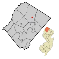 Map of Sussex County highlighting Sussex Borough. Inset: Location of Sussex County in the State of New Jersey. | |
 Census Bureau map of Sussex, New Jersey | |
 Sussex Location in Sussex County  Sussex Location in New Jersey  Sussex Location in the United States | |
| Coordinates: 41.208771°N 74.608241°W[1][2] | |
| Country | |
| State | |
| County | |
| Incorporated | October 14, 1891 as Deckertown |
| Renamed | March 2, 1902 as Sussex |
| Named for | Sussex, England |
| Government | |
| • Type | Borough |
| • Body | Borough Council |
| • Mayor | Edward J. Meyer (R, term ends December 31, 2023)[4][5] |
| • Administrator / Municipal clerk | Antoinette Smith[6] |
| Area | |
| • Total | 0.62 sq mi (1.62 km2) |
| • Land | 0.59 sq mi (1.54 km2) |
| • Water | 0.03 sq mi (0.08 km2) 5.00% |
| Area rank | 536th of 565 in state 23rd of 24 in county[1] |
| Elevation | 449 ft (137 m) |
| Population | |
| • Total | 2,130 |
| • Estimate (2019)[11] | 1,985 |
| • Rank | 481st of 566 in state 20th of 24 in county[12] |
| • Density | 3,615.9/sq mi (1,396.1/km2) |
| • Density rank | 176th of 566 in state 1st of 24 in county[12] |
| Time zone | UTC−05:00 (Eastern (EST)) |
| • Summer (DST) | UTC−04:00 (Eastern (EDT)) |
| ZIP Code | |
| Area code(s) | 973 exchanges: 702, 875[15] |
| FIPS code | 3403771670[1][16][17] |
| GNIS feature ID | 0885414[1][18] |
| Website | www |
Sussex was incorporated as a borough by an act of the New Jersey Legislature on October 14, 1891, as Deckertown, from portions of Wantage Township.[20] The borough's original name was for settler Peter Decker.[21] The borough was renamed Sussex on March 2, 1902.[20] The county and borough are named for the historic county of Sussex in England.[22][23]
A joint commission of residents of both Sussex and Wantage had recommended that the two communities should be consolidated to form what would be called the Township of Sussex-Wantage, which would operate within the Faulkner Act under the council-manager form of government, with a mayor and a six-member township council, and that voters in both municipalities should approve a referendum to be held on November 3, 2009. The committee noted that the two municipalities share common issues, schools, library and community services and that the artificial nature of the octagonal Sussex border often made it hard to distinguish between the two.[24] The efforts at consolidation with surrounding Wantage Township ended in November 2009 after Wantage voters rejected the merger despite support from Sussex borough residents.[25]
Geography
According to the United States Census Bureau, Sussex borough had a total area of 0.62 square miles (1.62 km2), including 0.59 square miles (1.54 km2) of land and 0.03 square miles (0.08 km2) of water (5.00%).[1][2] It is approximately 400 to 450 feet (120 to 140 m) above sea level.[26]
The borough is completely surrounded by Wantage Township,[27][28] making it part of 21 pairs of "doughnut towns" in the state, where one municipality entirely surrounds another.[29]
The borough is in the watershed of the Wallkill River (which flows north, and empties into the Rondout Creek, which flows into the Hudson River near Kingston, New York) and its tributary Glen Brook, which near Sussex forms a small body of water called Clove Lake, part of which is within the borough.
Climate
Due to its inland location and elevation, Sussex has a climate much cooler than most of the state, classified as humid continental (Köppen Dfb), with cold, moderately snowy winters, and very warm, humid summers. It is part of USDA Plant Hardiness Zone 6.[30] The monthly daily average temperature ranges from 25.0 °F (−3.9 °C) in January to 71.1 °F (21.7 °C) in July. Temperatures reach 90 °F (32 °C) on 12.6 days and fall to 0 °F (−18 °C) on 6 nights annually. Snowfall averages 42 inches (107 cm) per season, although this usually varies widely from year to year. Extremes in temperature range from −29 °F (−34 °C) on January 21, 1994 up to 106 °F (41 °C) on July 10, 1936.
| Climate data for Sussex, New Jersey (Sussex County Airport) 1981–2010 normals | |||||||||||||
|---|---|---|---|---|---|---|---|---|---|---|---|---|---|
| Month | Jan | Feb | Mar | Apr | May | Jun | Jul | Aug | Sep | Oct | Nov | Dec | Year |
| Record high °F (°C) | 71 (22) |
77 (25) |
90 (32) |
95 (35) |
97 (36) |
98 (37) |
106 (41) |
102 (39) |
102 (39) |
92 (33) |
84 (29) |
75 (24) |
106 (41) |
| Average high °F (°C) | 34.1 (1.2) |
37.9 (3.3) |
46.8 (8.2) |
58.9 (14.9) |
69.8 (21.0) |
77.8 (25.4) |
82.3 (27.9) |
80.8 (27.1) |
73.1 (22.8) |
62.2 (16.8) |
50.9 (10.5) |
38.7 (3.7) |
59.4 (15.2) |
| Average low °F (°C) | 15.8 (−9.0) |
17.9 (−7.8) |
25.7 (−3.5) |
36.1 (2.3) |
45.4 (7.4) |
55.1 (12.8) |
60.0 (15.6) |
58.0 (14.4) |
50.1 (10.1) |
38.4 (3.6) |
31.0 (−0.6) |
21.6 (−5.8) |
37.9 (3.3) |
| Record low °F (°C) | −29 (−34) |
−23 (−31) |
−10 (−23) |
9 (−13) |
24 (−4) |
33 (1) |
40 (4) |
34 (1) |
27 (−3) |
13 (−11) |
6 (−14) |
−13 (−25) |
−29 (−34) |
| Average precipitation inches (mm) | 3.19 (81) |
2.83 (72) |
3.69 (94) |
4.27 (108) |
4.10 (104) |
4.41 (112) |
4.02 (102) |
4.18 (106) |
4.23 (107) |
4.52 (115) |
3.47 (88) |
3.74 (95) |
46.65 (1,184) |
| Average snowfall inches (cm) | 13.8 (35) |
9.4 (24) |
6.5 (17) |
2.0 (5.1) |
0 (0) |
0 (0) |
0 (0) |
0 (0) |
0 (0) |
0 (0) |
1.3 (3.3) |
9.2 (23) |
42.2 (107.4) |
| Average precipitation days (≥ 0.01 in) | 10.6 | 8.6 | 11.1 | 12.4 | 12.6 | 11.0 | 10.9 | 10.7 | 9.1 | 10.1 | 9.9 | 10.7 | 127.7 |
| Average snowy days (≥ 0.1 in) | 5.4 | 3.7 | 2.6 | .5 | 0 | 0 | 0 | 0 | 0 | .1 | .6 | 3.2 | 16.1 |
| Source: NOAA (extremes 1893–present)[31] | |||||||||||||
Demographics
| Historical population | |||
|---|---|---|---|
| Census | Pop. | %± | |
| 1880 | 370 | — | |
| 1890 | 993 | 168.4% | |
| 1900 | 1,306 | 31.5% | |
| 1910 | 1,212 | −7.2% | |
| 1920 | 1,318 | 8.7% | |
| 1930 | 1,415 | 7.4% | |
| 1940 | 1,478 | 4.5% | |
| 1950 | 1,541 | 4.3% | |
| 1960 | 1,656 | 7.5% | |
| 1970 | 2,038 | 23.1% | |
| 1980 | 2,418 | 18.6% | |
| 1990 | 2,201 | −9.0% | |
| 2000 | 2,145 | −2.5% | |
| 2010 | 2,130 | −0.7% | |
| 2019 (est.) | 1,985 | [11][32] | −6.8% |
| Population sources: 1880-1890[33] 1890-1920[34] 1890-1910[35] 1910-1930[36] 1930-1990[37] 2000[38][39] 2010[8][9][10] | |||
2010 Census
The 2010 United States Census counted 2,130 people, 899 households, and 525 families in the borough. The population density was 3,615.9 per square mile (1,396.1/km2). There were 1,005 housing units at an average density of 1,706.1 per square mile (658.7/km2). The racial makeup was 91.03% (1,939) White, 1.92% (41) Black or African American, 0.33% (7) Native American, 2.30% (49) Asian, 0.42% (9) Pacific Islander, 1.36% (29) from other races, and 2.63% (56) from two or more races. Hispanic or Latino of any race were 7.93% (169) of the population.[8]
Of the 899 households, 26.8% had children under the age of 18; 36.8% were married couples living together; 15.5% had a female householder with no husband present and 41.6% were non-families. Of all households, 36.9% were made up of individuals and 12.8% had someone living alone who was 65 years of age or older. The average household size was 2.32 and the average family size was 3.04.[8]
22.8% of the population were under the age of 18, 9.6% from 18 to 24, 27.3% from 25 to 44, 28.1% from 45 to 64, and 12.3% who were 65 years of age or older. The median age was 38.7 years. For every 100 females, the population had 100.9 males. For every 100 females ages 18 and older there were 98.2 males.[8]
The Census Bureau's 2006-2010 American Community Survey showed that (in 2010 inflation-adjusted dollars) median household income was $40,978 (with a margin of error of +/- $13,975) and the median family income was $53,125 (+/- $10,034). Males had a median income of $40,234 (+/- $9,777) versus $30,777 (+/- $3,942) for females. The per capita income for the borough was $20,887 (+/- $2,314). About 13.0% of families and 15.1% of the population were below the poverty line, including 22.4% of those under age 18 and 12.0% of those age 65 or over.[40]
2000 Census
As of the 2000 United States Census[16] there were 2,145 people, 903 households, and 512 families residing in the borough. The population density was 3,598 people per square mile (1,380/km2). There were 961 housing units at an average density of 1,612/sq mi (618/km2). The racial makeup of the borough was 96.32% White, 1.12% African American, 0.09% Native American, 1.21% Asian, 0.37% from other races, and 0.89% from two or more races. Hispanic or Latino of any race were 2.56% of the population.[38][39]
There were 903 households, out of which 28.3% had children under the age of 18 living with them, 38.9% were married couples living together, 12.6% had a female householder with no husband present, and 43.2% were non-families. 35.1% of all households were made up of individuals, and 12.6% had someone living alone who was 65 years of age or older. The average household size was 2.36 and the average family size was 3.12.[38][39]
In the borough the population was spread out, with 23.9% under the age of 18, 8.5% from 18 to 24, 32.9% from 25 to 44, 22.0% from 45 to 64, and 12.7% who were 65 years of age or older. The median age was 36 years. For every 100 females, there were 91.5 males. For every 100 females age 18 and over, there were 91.8 males.[38][39]
The median income for a household in the borough was $36,172, and the median income for a family was $45,250. Males had a median income of $37,009 versus $22,475 for females. The per capita income for the borough was $18,866. About 6.9% of families and 11.0% of the population were below the poverty line, including 15.6% of those under age 18 and 8.4% of those age 65 or over.[38][39]
Government
Local government
Sussex is governed under the Borough form of New Jersey municipal government, which is used in 218 municipalities (of the 565) statewide, making it the most common form of government in New Jersey.[41] The governing body is comprised of the Mayor and the Borough Council, with all positions elected at-large on a partisan basis as part of the November general election. The Mayor is elected directly by the voters to a four-year term of office. The Borough Council is comprised of six members elected to serve three-year terms on a staggered basis, with two seats coming up for election each year in a three-year cycle.[3] The Borough form of government used by Sussex is a "weak mayor / strong council" government in which council members act as the legislative body with the mayor presiding at meetings and voting only in the event of a tie. The mayor can veto ordinances subject to an override by a two-thirds majority vote of the council. The mayor makes committee and liaison assignments for council members, and most appointments are made by the mayor with the advice and consent of the council.[42][43]
As of 2020, the Mayor of Sussex Borough is Republican Edward J. Meyer, whose term of office ends on December 31, 2023. Members of the Borough Council are Council President Council President Robert Holowach (R, 2020), Michael John Brennan (R, 2020), Walter Cleary III (R, 2022), Charles H. Fronheiser Jr. (R, 2021), Linda Masson (R, 2021; appointed to serve an unexpired term) and Mario Poggi (R, 2022).[4][44][45][46][47]
In January 2020, the Borough Council selected Linda Masson from a list of three candidates nominated by the Republican municipal committee to fill the seat expiring in December 2021 that was vacated by Edward Meyer when he took office as mayor.[48]
In January 2016, the council appointed Albert Decker from a list three candidates nominated by the Democratic municipal committee to fill the council seat vacated by Katherine Little expiring in December 2017 that became open when she took office as mayor; Decker will serve on an interim basis until the November 2016 general election, when voters will select a candidate to serve the one year remaining on the term of office.[49]
In January 2015, the Borough Council selected Mario Poggi from three candidates nominated by the Republican municipal committee to fill the vacant seat of Bruce D. LaBar, who resigned from office earlier that month.[50] In the November 2015 general election, Frank Dykstra was chosen to fill the balance of the seat expiring in December 2016.[51]
Federal, state and county representation
Sussex Borough is located in the 5th Congressional District[52] and is part of New Jersey's 24th state legislative district.[9][53][54]
For the 116th United States Congress, New Jersey's Fifth Congressional District is represented by Josh Gottheimer (D, Wyckoff).[55][56] New Jersey is represented in the United States Senate by Democrats Cory Booker (Newark, term ends 2021)[57] and Bob Menendez (Paramus, term ends 2025).[58][59]
For the 2018–2019 session (Senate, General Assembly), the 24th Legislative District of the New Jersey Legislature is represented in the State Senate by Steve Oroho (R, Franklin) and in the General Assembly by Parker Space (R, Wantage Township) and Harold J. Wirths (R, Hardyston Township).[60][61]
Sussex County is governed by a Board of Chosen Freeholders whose five members are elected at-large in partisan elections on a staggered basis, with either one or two seats coming up for election each year. At an annual reorganization meeting held in the beginning of January, the board selects a Freeholder Director and Deputy Director from among its members, with day-to-day supervision of the operation of the county delegated to a County Administrator.[62] As of 2014, Sussex County's Freeholders are Freeholder Director Richard Vohden (R, Green Township, 2016),[63] Deputy Director Dennis J. Mudrick (R, Sparta Township, 2015),[64] Phillip R. Crabb (R, Franklin, 2014),[65] George Graham (R, Stanhope, 2016)[66] and Gail Phoebus (R, Andover Township, 2015).[67][62] Graham was chosen in April 2013 to fill the seat vacated by Parker Space, who had been chosen to fill a vacancy in the New Jersey General Assembly.[68] Constitutional officers elected on a countywide basis are County Clerk Jeff Parrott (R, 2016),[69] Sheriff Michael F. Strada (R, 2016)[70] and Surrogate Gary R. Chiusano (R, filling the vacancy after the resignation of Nancy Fitzgibbons).[71][68] The County Administrator is John Eskilson.[72][73]
Politics
As of March 23, 2011, there were a total of 1,143 registered voters in Sussex, of which 193 (16.9% vs. 16.5% countywide) were registered as Democrats, 428 (37.4% vs. 39.3%) were registered as Republicans and 521 (45.6% vs. 44.1%) were registered as Unaffiliated. There was one voter registered to another party.[74] Among the borough's 2010 Census population, 53.7% (vs. 65.8% in Sussex County) were registered to vote, including 69.5% of those ages 18 and over (vs. 86.5% countywide).[74][75]
In the 2012 presidential election, Republican Mitt Romney received 391 votes (57.8% vs. 59.4% countywide), ahead of Democrat Barack Obama with 270 votes (39.9% vs. 38.2%) and other candidates with 16 votes (2.4% vs. 2.1%), among the 677 ballots cast by the borough's 1,146 registered voters, for a turnout of 59.1% (vs. 68.3% in Sussex County).[76] In the 2008 presidential election, Republican John McCain received 427 votes (57.1% vs. 59.2% countywide), ahead of Democrat Barack Obama with 299 votes (40.0% vs. 38.7%) and other candidates with 18 votes (2.4% vs. 1.5%), among the 748 ballots cast by the borough's 1,109 registered voters, for a turnout of 67.4% (vs. 76.9% in Sussex County).[77] In the 2004 presidential election, Republican George W. Bush received 456 votes (62.0% vs. 63.9% countywide), ahead of Democrat John Kerry with 263 votes (35.7% vs. 34.4%) and other candidates with 16 votes (2.2% vs. 1.3%), among the 736 ballots cast by the borough's 1,091 registered voters, for a turnout of 67.5% (vs. 77.7% in the whole county).[78]
In the 2013 gubernatorial election, Republican Chris Christie received 70.8% of the vote (276 cast), ahead of Democrat Barbara Buono with 25.4% (99 votes), and other candidates with 3.8% (15 votes), among the 397 ballots cast by the borough's 1,148 registered voters (7 ballots were spoiled), for a turnout of 34.6%.[79][80] In the 2009 gubernatorial election, Republican Chris Christie received 291 votes (56.8% vs. 63.3% countywide), ahead of Democrat Jon Corzine with 140 votes (27.3% vs. 25.7%), Independent Chris Daggett with 59 votes (11.5% vs. 9.1%) and other candidates with 16 votes (3.1% vs. 1.3%), among the 512 ballots cast by the borough's 1,109 registered voters, yielding a 46.2% turnout (vs. 52.3% in the county).[81]
Education
Students in public school for kindergarten through eighth grade attend the Sussex-Wantage Regional School District, together with students from Wantage Township.[82] As of the 2018–19 school year, the district, comprised of three schools, had an enrollment of 1,043 students and 104.5 classroom teachers (on an FTE basis), for a student–teacher ratio of 10.0:1.[83] Schools in the district (with 2018–19 enrollment data from the National Center for Education Statistics[84]) are Clifton E. Lawrence School[85] in Wantage, with 353 students in grades K - 2, Wantage Elementary School[86] in Sussex, with 355 students in grades 3–5 and Sussex Middle School[87] in Sussex, with 328 students in grades 6–8.[88][89][90]
For ninth through twelfth grades, public school students from both Sussex and Wantage attend High Point Regional High School, together with students from Branchville, Frankford Township, Lafayette Township and Montague Township.[91][92][93] As of the 2018–19 school year, the high school had an enrollment of 893 students and 81.9 classroom teachers (on an FTE basis), for a student–teacher ratio of 10.9:1.[94] Seats on the high school district's nine-member board of education are allocated based on the population of the constituent municipalities, with two seats assigned to Sussex.[95]
Sussex Christian School is an inter-denominational Christian private day school that was founded in 1958 by members of the Sussex Christian Reformed Church, and which serves students from Northern New Jersey and the surrounding communities in New York and Pennsylvania.[96]
Transportation
_just_north_of_Sussex_County_Route_639_(Loomis_Avenue)_in_Sussex%252C_Sussex_County%252C_New_Jersey.jpg.webp)
Roads and highways
As of May 2010, the borough had a total of 9.21 miles (14.82 km) of roadways, of which 6.67 miles (10.73 km) were maintained by the municipality, 0.87 miles (1.40 km) by Sussex County and 1.67 miles (2.69 km) by the New Jersey Department of Transportation.[97]
Sussex is located at the intersection of Route 23 and Route 284.
Public transportation
Local bus service is provided by the Skylands Connect bus, which provides service to Hamburg, Sparta, and Newton.[98]
Sussex Airport is located 1 mile (1.6 km) southwest of Sussex.[99]
Notable people
People who were born in, residents of, or otherwise closely associated with Sussex include:
- Grant Decker (1814–1890), first mayor of Flint, Michigan, born in Sussex
- D. C. Fontana (1939–2019), television script writer and story editor, best known for her work on the original Star Trek franchise and several western television series.[100]
- Bill Glynn (1925–2013), Major League Baseball first baseman who played four seasons of professional baseball for the Cleveland Indians and the Philadelphia Phillies.[101]
- William Alexander Linn (1846–1917), journalist and historian.[102]
- Homer Mensch (1914–2005), classical bassist.[103]
References
- 2019 Census Gazetteer Files: New Jersey Places, United States Census Bureau. Accessed July 1, 2020.
- US Gazetteer files: 2010, 2000, and 1990, United States Census Bureau. Accessed September 4, 2014.
- 2012 New Jersey Legislative District Data Book, Rutgers University Edward J. Bloustein School of Planning and Public Policy, March 2013, p. 110.
- Mayor and Council, Sussex Borough. Accessed March 10, 2020.
- 2020 New Jersey Mayors Directory, New Jersey Department of Community Affairs. Accessed February 1, 2020.
- Municipal Clerk / Administrator, Borough of Sussex. Accessed March 10, 2020.
- U.S. Geological Survey Geographic Names Information System: Borough of Sussex, Geographic Names Information System. Accessed March 14, 2013.
- DP-1 - Profile of General Population and Housing Characteristics: 2010 for Sussex borough, Sussex County, New Jersey Archived February 12, 2020, at Archive.today, United States Census Bureau. Accessed April 2, 2012.
- Municipalities Sorted by 2011-2020 Legislative District, New Jersey Department of State. Accessed February 1, 2020.
- Table DP-1. Profile of General Demographic Characteristics: 2010 for Sussex borough Archived August 30, 2014, at the Wayback Machine, New Jersey Department of Labor and Workforce Development. Accessed April 4, 2012.
- Annual Estimates of the Resident Population for Minor Civil Divisions in New Jersey: April 1, 2010 to July 1, 2019, United States Census Bureau. Accessed May 21, 2020.
- GCT-PH1 Population, Housing Units, Area, and Density: 2010 - State -- County Subdivision from the 2010 Census Summary File 1 for New Jersey Archived February 12, 2020, at Archive.today, United States Census Bureau. Accessed February 26, 2013.
- Look Up a ZIP Code for Sussex, NJ, United States Postal Service. Accessed April 4, 2012.
- Zip Codes, State of New Jersey. Accessed August 30, 2013.
- Area Code Lookup - NPA NXX for Sussex, NJ, Area-Codes.com. Accessed August 30, 2013.
- U.S. Census website, United States Census Bureau. Accessed September 4, 2014.
- Geographic codes for New Jersey, Missouri Census Data Center. Accessed September 1, 2019.
- US Board on Geographic Names, United States Geological Survey. Accessed September 4, 2014.
- Table 7. Population for the Counties and Municipalities in New Jersey: 1990, 2000 and 2010, New Jersey Department of Labor and Workforce Development, February 2011. Accessed February 26, 2013.
- Snyder, John P. The Story of New Jersey's Civil Boundaries: 1606-1968, Bureau of Geology and Topography; Trenton, New Jersey; 1969. pp. 229 and 232. Accessed April 2, 2012.
- History of Sussex Boro - Sussex County, New Jersey, NY-NJ-CT Botany Online. Accessed October 11, 2015. "The village was known as Deckertown in honor of early settler Peter Decker."
- Hutchinson, Viola L. The Origin of New Jersey Place Names, New Jersey Public Library Commission, May 1945. Accessed October 11, 2015.
- Gannett, Henry. The Origin of Certain Place Names in the United States, p. 294. United States Government Printing Office, 1905. Accessed October 11, 2015.
- Borough of Sussex and Township of Wantage: Joint Municipal Consolidation Study Commission Report. Wantage Township, New Jersey. Accessed April 4, 2012.
- Donohue, Brian. "Sussex, Wantage reject merger; home rule still rules in New Jersey", The Star-Ledger, November 13, 2009. Accessed April 4, 2012. "That's just what happened last week in the Township of Wantage, where voters rejected a ballot measure that would have joined the town with the tiny Borough of Sussex. Sussex is essentially Wantage's downtown, cut off from the surrounding township in a feud over utilities costs in the late 1800s. Sussex voters were largely for the reunion."
- New Jersey Encyclopedia. Leinaweaver, Chad E., Herman, Jennifer L. State History Pub. 2008. p. 366. ISBN 978-1-878592-44-6. OCLC 401145520.CS1 maint: others (link)
- Sussex County Map, Sussex County, New Jersey. Accessed March 10, 2020.
- New Jersey Municipal Boundaries, New Jersey Department of Transportation. Accessed November 15, 2019.
- DeMarco, Megan. "Voters to decide whether to merge two Princetons into one", The Star-Ledger, November 3, 2011. Accessed January 8, 2017. "There are 22 sets of 'doughnut towns' in New Jersey, those where one town wraps around the other town". Note that following voter approval of the Princeton merger, 21 pairs of "doughnut towns" remain.
- What is my arborday.org Hardiness Zone?, Arbor Day Foundation. Accessed March 31, 2013.
- NowData - NOAA Online Weather Data, National Oceanic and Atmospheric Administration. Accessed March 4, 2012.
- Census Estimates for New Jersey April 1, 2010 to July 1, 2019, United States Census Bureau. Accessed May 21, 2020.
- Report on Population of the United States at the Eleventh Census: 1890. Part I, p. 239. United States Census Bureau, 1895. Accessed October 20, 2016.
- Compendium of censuses 1726-1905: together with the tabulated returns of 1905, New Jersey Department of State, 1906. Accessed August 30, 2013.
- Thirteenth Census of the United States, 1910: Population by Counties and Minor Civil Divisions, 1910, 1900, 1890, United States Census Bureau, p. 338. Accessed February 25, 2013.
- Fifteenth Census of the United States : 1930 - Population Volume I, United States Census Bureau, p. 719. Accessed April 4, 2012.
- Table 6. New Jersey Resident Population by Municipality: 1930 - 1990, New Jersey Department of Labor and Workforce Development. Accessed June 28, 2015.
- Census 2000 Profiles of Demographic / Social / Economic / Housing Characteristics for Sussex borough, New Jersey Archived January 13, 2016, at the Wayback Machine, United States Census Bureau. Accessed February 26, 2013.
- DP-1: Profile of General Demographic Characteristics: 2000 - Census 2000 Summary File 1 (SF 1) 100-Percent Data for Sussex borough, Sussex County, New Jersey Archived February 12, 2020, at Archive.today, United States Census Bureau. Accessed February 26, 2013.
- DP03: Selected Economic Characteristics from the 2006-2010 American Community Survey 5-Year Estimates for Sussex borough, Sussex County, New Jersey Archived February 12, 2020, at Archive.today, United States Census Bureau. Accessed April 4, 2012.
- Inventory of Municipal Forms of Government in New Jersey, Rutgers University Center for Government Studies, July 1, 2011. Accessed November 18, 2019.
- Cerra, Michael F. "Forms of Government: Everything You've Always Wanted to Know, But Were Afraid to Ask" Archived September 24, 2014, at the Wayback Machine, New Jersey State League of Municipalities. Accessed November 30, 2014.
- "Forms of Municipal Government in New Jersey", p. 6. Rutgers University Center for Government Studies. Accessed June 3, 2015.
- 2019 Municipal User Friendly Budget, Sussex Borough. Accessed March 10, 2020.
- Sussex County, New Jersey General Election November 5, 2019, Official Results Summary Report, Sussex County, New Jersey, dated November 8, 2019. Accessed January 1, 2020.
- Sussex County, New Jersey General Election November 6, 2018, Official Results Summary Report, Sussex County, New Jersey, dated November 9, 2018. Accessed January 1, 2019.
- Sussex County, New Jersey General Election November 7, 2017, Official Results Summary Report, Sussex County, New Jersey, dated November 9, 2017. Accessed January 1, 2018.
- Mayor and Council Minutes for January 21, 2020, Borough of Sussex. Accessed March 11, 2020. "Mr. Brennan made a motion to appoint Linda Masson to fill the vacancy created by the resignation of Mr. Edward Meyer. The interim Council Member’s term of office shall end when the votes are certified after the November 2020 general election.... Mayor Meyer administered the oath of office to the interim Council Member, Linda Masson."
- Olinski, Vera. "New council members take seats; Residents question temporary mayor's 2015 vetoes", The Advertiser News, January 18, 2016. Accessed May 5, 2016. "Municipal Clerk Mark Zschack administered the Oath of Office Jan. 5 at the Sussex Borough Council reorganization meeting to three Council members, and on Jan. 19, the council appointed Albert Decker to take the place of newly elected mayor Katherine Little on the council."
- Staff. "Sussex installs new councilman", The Advertiser News, January 21, 2015. Accessed April 15, 2015. "On the heels of Councilman Bruce LaBar's resignation Jan. 7, the Sussex Borough Council unanimously selected Mario Poggi to take LaBar's place on Tuesday. Poggi will serve the remainder of LaBar's 2015 Sussex Borough Council term."
- Sussex County General Election November 3, 2015 Summary Report Official Results, Sussex County, New Jersey Clerk, updated November 6, 2015. Accessed August 1, 2016.
- Plan Components Report, New Jersey Redistricting Commission, December 23, 2011. Accessed February 1, 2020.
- 2019 New Jersey Citizen's Guide to Government, New Jersey League of Women Voters. Accessed October 30, 2019.
- Districts by Number for 2011-2020, New Jersey Legislature. Accessed January 6, 2013.
- Directory of Representatives: New Jersey, United States House of Representatives. Accessed January 3, 2019.
- Biography, Congressman Josh Gottheimer. Accessed January 3, 2019. "Josh now lives in Wyckoff, New Jersey with Marla, his wife who was a federal prosecutor, and their two young children, Ellie and Ben."
- About Cory Booker, United States Senate. Accessed January 26, 2015. "He now owns a home and lives in Newark's Central Ward community."
- Biography of Bob Menendez, United States Senate, January 26, 2015. "He currently lives in Paramus and has two children, Alicia and Robert."
- Senators of the 116th Congress from New Jersey. United States Senate. Accessed April 17, 2019. "Booker, Cory A. - (D - NJ) Class II; Menendez, Robert - (D - NJ) Class I"
- Legislative Roster 2018-2019 Session, New Jersey Legislature. Accessed January 22, 2018.
- District 24 Legislators, New Jersey Legislature. Accessed January 22, 2018.
- Sussex County Board of Chosen Freeholders, Sussex County, New Jersey. Accessed July 28, 2014.
- Richard A. Vohden, Sussex County, New Jersey. Accessed July 28, 2014.
- Dennis J. Mudrick, Sussex County, New Jersey. Accessed July 28, 2014.
- Phillip R. Crabb, Sussex County, New Jersey. Accessed July 28, 2014.
- George Graham, Sussex County, New Jersey. Accessed July 28, 2014.
- Gail Phoebus, Sussex County, New Jersey. Accessed July 28, 2014.
- Miller, Jennifer Jean. "George Graham Chosen as Freeholder at Sussex County Republican Convention", TheAlternativePress.com, April 13, 2013. Accessed April 25, 2013. "Graham will fill the freeholder seat that New Jersey Assemblyman Parker Space left to take his new position. Space recently took the seat, which formerly belonged to Gary Chiusano, who in turn, was appointed to the spot of Sussex County Surrogate, following the retirement of Surrogate Nancy Fitzgibbons."
- Home Page, Sussex County Clerk's Office. Accessed July 28, 2014.
- Sheriff's Office, Sussex County, New Jersey. Accessed July 28, 2014.
- Home Page, Sussex County Surrogate. Accessed July 28, 2014.
- County Administrator, Sussex County, New Jersey. Accessed July 28, 2014.
- Sussex County Official Directory 2014, Sussex County, New Jersey. Accessed July 28, 2014.
- Voter Registration Summary - Sussex, New Jersey Department of State Division of Elections, March 23, 2011. Accessed February 26, 2013.
- GCT-P7: Selected Age Groups: 2010 - State -- County Subdivision; 2010 Census Summary File 1 for New Jersey Archived February 12, 2020, at Archive.today, United States Census Bureau. Accessed February 26, 2013.
- General Election November 6, 2012: District Report - Group Detail Archived June 6, 2013, at the Wayback Machine, Sussex County, New Jersey Clerk, run date November 30, 2012. Accessed February 26, 2013.
- 2008 Presidential General Election Results: Sussex County, New Jersey Department of State Division of Elections, December 23, 2008. Accessed February 26, 2013.
- 2004 Presidential Election: Sussex County, New Jersey Department of State Division of Elections, December 13, 2004. Accessed February 26, 2013.
- "Governor - Sussex County" (PDF). New Jersey Department of Elections. January 29, 2014. Retrieved December 24, 2014.
- "Number of Registered Voters and Ballots Cast - November 5, 2013 - General Election Results - Sussex County" (PDF). New Jersey Department of Elections. January 29, 2014. Retrieved December 24, 2014.
- 2009 Governor: Sussex County Archived June 6, 2013, at the Wayback Machine, New Jersey Department of State Division of Elections, December 31, 2009. Accessed February 26, 2013.
- Sussex-Wantage Regional Board of Education District Policy 0110 - Identification, Sussex-Wantage Regional School District. Accessed June 18, 2020. "Purpose: The Board of Education exists for the purpose of providing a thorough and efficient system of free public education in grades Pre-Kindergarten through eight in the Sussex-Wantage Regional School District. Composition: The Sussex-Wantage Regional School District is comprised of all the area within the municipal boundaries of Sussex Borough and Wantage Township."
- District information for Sussex-Wantage Regional School District, National Center for Education Statistics. Accessed April 1, 2020.
- School Data for the Sussex-Wantage Regional School District, National Center for Education Statistics. Accessed April 1, 2020.
- Clifton E. Lawrence School, Sussex-Wantage Regional School District. Accessed June 18, 2020.
- Wantage Elementary School, Sussex-Wantage Regional School District. Accessed June 18, 2020.
- Sussex Middle School, Sussex-Wantage Regional School District. Accessed June 18, 2020.
- School Hours, Sussex-Wantage Regional School District. Accessed June 18, 2020.
- Public School Directory 2019-2020, Sussex County, New Jersey. Accessed May 17, 2020.
- New Jersey School Directory for the Sussex-Wantage Regional School District, New Jersey Department of Education. Accessed December 29, 2016.
- Sussex-Wantage Regional School District 2014 Report Card Narrative, New Jersey Department of Education. Accessed June 18, 2020. "Our district serves over 1,200 students in three schools: Pre-School through Grade 2 in the Clifton E. Lawrence School, Grades 3–5 in the Wantage School, and Grades 6–8 in the Sussex Middle School. Our students attend High Point Regional High School in Grade 9, along with students from the Lafayette and Frankford Township School Districts."
- High Point Regional High School 2016 Report Card Narrative, New Jersey Department of Education. Accessed June 18, 2020. "High Point Regional High School is a comprehensive high school serving the diversified needs of the five surrounding municipalities of Branchville, Frankford, Lafayette, Sussex and Wantage. In addition, we are in a send/receive relationship with the Montague school district."
- "2019-20 School Profile", High Point Regional High School. Accessed June 18, 2020. "Located 63 miles northwest of Manhattan in bucolic Sussex, County NJ, High Point serves students from six municipalities: Branchville, Lafayette, Frankford, Montague, Sussex, and Wantage."
- School data for High Point Regional High School District, National Center for Education Statistics. Accessed April 1, 2020.
- Board of Education, Sussex-Wantage Regional School District. Accessed June 18, 2020.
- Our Heritage, Sussex Christian School. Accessed May 19, 2011.
- Sussex County Mileage by Municipality and Jurisdiction, New Jersey Department of Transportation, May 2010. Accessed July 21, 2014.
- Skylands Connect, Sussex County. Accessed July 21, 2014.
- Sussex Airport, AirNav.com. Accessed April 4, 2012.
- Beckerman, Jim. "Ex-Totowa resident a shaper of Star Trek", The Record, September 8, 2016. Accessed September 12, 2016. "'That was kind of the only way at the time,' says Fontana, who was born in Sussex, moved to Totowa a year later, and lived there for the next 19 years."
- Marsh, Richard. Bill Glynn, Society for American Baseball Research. Accessed August 11, 2016. "William Vincent Glynn, who played for three seasons with the Indians in a four-year major-league career, was born on June 30, 1925, in Sussex, New Jersey, the second son of Marshall Nelson, a laborer in a zinc mine, and his wife, Esta. A premier athlete at Franklin High School, Glynn lettered as a first baseman in baseball, a running back in football, and a forward in basketball."
- A Thousand American Men of Mark To-day, p. 260. Accessed November 15, 2017. "William Alexander Linn - Lawyer, Banker, Author of Hackensack, N.J. was born Sept 4. 1846, in Sussex, N.J"
- Applebaum, Samuel; and Applebaum, Sara. The Way They Play, Book 2, p. 333. Paganiniana Publications, 1972. ISBN 9780876664384. Accessed June 18, 2020. "Homer R. Mensch, born November 13, 1914 in Sussex, New Jersey."
External links
| Wikimedia Commons has media related to Sussex, New Jersey. |
- Sussex Borough official website
- Sussex County webpage for Sussex Borough
- Sussex-Wantage Regional School District
- Sussex-Wantage Regional School District's 2015–16 School Report Card from the New Jersey Department of Education
- School Data for the Sussex-Wantage Regional School District, National Center for Education Statistics
- High Point Regional High School
- The Advertiser-News, community newspaper
- Sussex Borough property, hazard, and crime stats at PogoData
Municipalities and communities of Sussex County, New Jersey, United States | ||
|---|---|---|
| Boroughs | 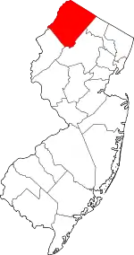 Map of New Jersey highlighting Sussex County | |
| Town | ||
| Townships | ||
| CDPs | ||
| Other unincorporated communities | ||
| ||
| Authority control |
|---|