Harlingen, New Jersey
Harlingen is an unincorporated community and census-designated place (CDP) located within Montgomery Township, in Somerset County, New Jersey, United States.[8][9][10][11] As of the 2010 United States Census, the CDP's population was 297.[4]
Harlingen, New Jersey | |
|---|---|
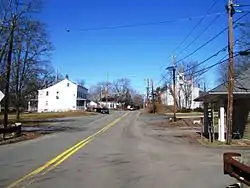 Harlingen as seen from westbound Harlingen Road | |
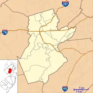 Harlingen, New Jersey Location of Harlingen within Somerset County. (Inset: Location of Somerset County in New Jersey).  Harlingen, New Jersey Harlingen, New Jersey (New Jersey)  Harlingen, New Jersey Harlingen, New Jersey (the United States) | |
| Coordinates: 40.449363°N 74.658505°W[1][2] | |
| Country | |
| State | |
| County | Somerset |
| Township | Montgomery |
| Area | |
| • Total | 0.717 sq mi (1.858 km2) |
| • Land | 0.717 sq mi (1.858 km2) |
| • Water | 0.000 sq mi (0.000 km2) 0.00% |
| Elevation | 79 ft (24 m) |
| Population | |
| • Total | 280 |
| • Density | 414.1/sq mi (159.9/km2) |
| Time zone | UTC-5 (Eastern (EST)) |
| • Summer (DST) | UTC-4 (Eastern (EDT)) |
| Area code(s) | 609/640 and 732/848 |
| FIPS code | 3429940[1][5][6] |
| GNIS feature ID | 02584000[1][7] |
It is adjacent to the historical areas of Dutchtown and Bridgepoint. Harlingen Road and U.S. Route 206 intersect in the center of Harlingen. The Harlingen Dutch Reformed Church on Route 206 is extant and had an associated cemetery. The town was a stop on the short-lived Mercer and Somerset Railway.
Geography
According to the United States Census Bureau, Harlingen had a total area of 0.717 square mile (1.858 km2), all of which was land.[1][2]
Demographics
| Historical population | |||
|---|---|---|---|
| Census | Pop. | %± | |
| 2010 | 297 | — | |
| Population sources: 2010[4] | |||
Census 2010
The 2010 United States Census counted 297 people, 93 households, and 81 families in the CDP. The population density was 414.1 per square mile (159.9/km2). There were 98 housing units at an average density of 136.6 per square mile (52.7/km2). The racial makeup was 77.78% (231) White, 1.68% (5) Black or African American, 0.00% (0) Native American, 16.50% (49) Asian, 0.00% (0) Pacific Islander, 2.36% (7) from other races, and 1.68% (5) from two or more races. Hispanic or Latino of any race were 5.72% (17) of the population.[4]
Of the 93 households, 54.8% had children under the age of 18; 79.6% were married couples living together; 4.3% had a female householder with no husband present and 12.9% were non-families. Of all households, 10.8% were made up of individuals and 3.2% had someone living alone who was 65 years of age or older. The average household size was 3.19 and the average family size was 3.46.[4]
30.6% of the population were under the age of 18, 7.4% from 18 to 24, 16.2% from 25 to 44, 38.7% from 45 to 64, and 7.1% who were 65 years of age or older. The median age was 42.3 years. For every 100 females, the population had 113.7 males. For every 100 females ages 18 and older there were 100.0 males.[4]
Harlingen Dutch Reformed Church
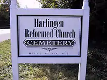
The Harlingen Dutch Reformed Church is in the Belle Mead, New Jersey section of Montgomery Township. The congregation was organized in 1727, and the minister was one of the major antagonists in the dispute between the traditionalists and the American party that contested governance of the Dutch Reformed Church. The church is still active.
References
- Gazetteer of New Jersey Places, United States Census Bureau. Accessed July 21, 2016.
- US Gazetteer files: 2010, 2000, and 1990, United States Census Bureau. Accessed September 4, 2014.
- U.S. Geological Survey Geographic Names Information System: Harlingen Census Designated Place, Geographic Names Information System. Accessed August 23, 2012.
- DP-1 - Profile of General Population and Housing Characteristics: 2010 Demographic Profile Data for Harlingen CDP, New Jersey, United States Census Bureau. Accessed February 13, 2013.
- U.S. Census website, United States Census Bureau. Accessed September 4, 2014.
- A Cure for the Common Codes: New Jersey, Missouri Census Data Center. Accessed February 13, 2013.
- US Board on Geographic Names, United States Geological Survey. Accessed September 4, 2014.
- GCT-PH1 - Population, Housing Units, Area, and Density: 2010 - County -- County Subdivision and Place from the 2010 Census Summary File 1 for Somerset County, New Jersey Archived 2020-02-12 at Archive.today, United States Census Bureau. Accessed February 13, 2013.
- 2006-2010 American Community Survey Geography for New Jersey, United States Census Bureau. Accessed February 13, 2013.
- New Jersey: 2010 - Population and Housing Unit Counts - 2010 Census of Population and Housing (CPH-2-32), United States Census Bureau, August 2012. Accessed February 13, 2013.
- Locality Search, State of New Jersey. Accessed April 18, 2015.
Municipalities and communities of Somerset County, New Jersey, United States | ||
|---|---|---|
| Boroughs | 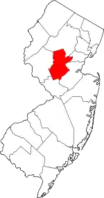 Map of New Jersey highlighting Somerset County | |
| Townships | ||
| CDPs | ||
| Other unincorporated communities | ||
| ||