Finderne, New Jersey
Finderne is an unincorporated community and census-designated place (CDP) located within Bridgewater Township, in Somerset County, New Jersey, United States.[8][9][10] As of the 2010 United States Census, the CDP's population was 5,600.[4]
Finderne, New Jersey | |
|---|---|
 Along East Main Street (CR 612) | |
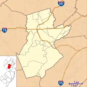 Finderne, New Jersey Location of Finderne within Somerset County. Inset: Location of Somerset County in New Jersey.  Finderne, New Jersey Finderne, New Jersey (New Jersey)  Finderne, New Jersey Finderne, New Jersey (the United States) | |
| Coordinates: 40.561278°N 74.574237°W[1][2] | |
| Country | |
| State | |
| County | Somerset |
| Township | Bridgewater |
| Area | |
| • Total | 4.336 sq mi (11.232 km2) |
| • Land | 4.095 sq mi (10.607 km2) |
| • Water | 0.241 sq mi (0.625 km2) 5.56% |
| Elevation | 82 ft (25 m) |
| Population | |
| • Total | 5,600 |
| • Density | 1,367.4/sq mi (528.0/km2) |
| Time zone | UTC-5 (Eastern (EST)) |
| • Summer (DST) | UTC-4 (Eastern (EDT)) |
| ZIP code | 08876 - Somerville[5] |
| Area code(s) | 908 |
| FIPS code | 3423310[1][6] |
| GNIS feature ID | 02583988[1][7] |
Located in southeastern Bridgewater between Bound Brook and Somerville, Finderne is a diverse area with older neighborhoods bordering Foothill Road, newer developments, multi-unit housing near the Raritan River/Manville border, as well as commercial and industrial areas. The Middlebrook Crossing industrial park, the Promenade shopping center and TD Bank Ballpark, home to the Somerset Patriots, are located here. Finderne is known for its sizable Costa Rican American population.
Geography
According to the United States Census Bureau, Finderne had a total area of 4.336 square miles (11.232 km2), including 4.095 square miles (10.607 km2) of land and 0.241 square miles (0.625 km2) of water (5.56%).[1][2]
Demographics
Census 2010
The 2010 United States Census counted 5,600 people, 2,147 households, and 1,327 families in the CDP. The population density was 1,367.4 per square mile (528.0/km2). There were 2,324 housing units at an average density of 567.5 per square mile (219.1/km2). The racial makeup was 70.86% (3,968) White, 5.61% (314) Black or African American, 0.29% (16) Native American, 14.77% (827) Asian, 0.00% (0) Pacific Islander, 5.93% (332) from other races, and 2.55% (143) from two or more races. Hispanic or Latino of any race were 21.04% (1,178) of the population.[4]
Of the 2,147 households, 29.5% had children under the age of 18; 45.8% were married couples living together; 11.6% had a female householder with no husband present and 38.2% were non-families. Of all households, 30.9% were made up of individuals and 14.3% had someone living alone who was 65 years of age or older. The average household size was 2.54 and the average family size was 3.19.[4]
20.7% of the population were under the age of 18, 7.1% from 18 to 24, 30.4% from 25 to 44, 25.1% from 45 to 64, and 16.6% who were 65 years of age or older. The median age was 39.4 years. For every 100 females, the population had 88.9 males. For every 100 females ages 18 and older there were 86.2 males.[4]
Points of interest
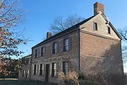
The Van Veghten House was built c. 1725 and served as the headquarters of Quartermaster General Nathanael Greene during the second Middlebrook encampment (winter of 1778–79) of the American Revolutionary War. The house was added to the National Register of Historic Places in 1979, and noted as representing "one of the few remaining Raritan River mansions".[11]
References
- Gazetteer of New Jersey Places, United States Census Bureau. Accessed July 21, 2016.
- US Gazetteer files: 2010, 2000, and 1990, United States Census Bureau. Accessed September 4, 2014.
- U.S. Geological Survey Geographic Names Information System: Finderne Census Designated Place, Geographic Names Information System. Accessed February 11, 2013.
- DP-1 - Profile of General Population and Housing Characteristics: 2010 Demographic Profile Data for Finderne CDP, New Jersey Archived 2020-02-12 at Archive.today, United States Census Bureau. Accessed February 11, 2013.
- Look Up a ZIP Code for Finderne, NJ, United States Postal Service. Accessed February 11, 2013.
- U.S. Census website , United States Census Bureau. Accessed September 4, 2014.
- US Board on Geographic Names, United States Geological Survey. Accessed September 4, 2014.
- GCT-PH1 - Population, Housing Units, Area, and Density: 2010 - County -- County Subdivision and Place from the 2010 Census Summary File 1 for Somerset County, New Jersey Archived 2020-02-12 at Archive.today, United States Census Bureau. Accessed February 11, 2013.
- 2006-2010 American Community Survey Geography for New Jersey, United States Census Bureau. Accessed February 11, 2013.
- New Jersey: 2010 - Population and Housing Unit Counts - 2010 Census of Population and Housing (CPH-2-32), United States Census Bureau, August 2012. Accessed February 11, 2013.
- Herfurth, Robert P. (October 10, 1979). "NRHP Nomination: Van Veghten House". National Park Service. Cite journal requires
|journal=(help) "Accompanying 3 photos, from 1979". Cite journal requires|journal=(help)
Municipalities and communities of Somerset County, New Jersey, United States | ||
|---|---|---|
| Boroughs | 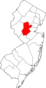 Map of New Jersey highlighting Somerset County | |
| Townships | ||
| CDPs | ||
| Other unincorporated communities | ||
| ||