Harrisburg, South Dakota
Harrisburg is a city in Lincoln County, South Dakota, United States and is a suburb of Sioux Falls. The population was 4,089 by the 2010 census, having grown from 958 in 2000. The population of the Harrisburg zip code rose from 2,476 in 2000 to 10,342 in 2010.
Harrisburg, South Dakota | |
|---|---|
| Motto(s): Great Things Are Happening | |
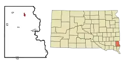 Location in Lincoln County and the state of South Dakota | |
 Harrisburg, South Dakota Location in the United States | |
| Coordinates: 43°25′46″N 96°41′46″W | |
| Country | United States |
| State | South Dakota |
| County | Lincoln |
| Government | |
| • Mayor | Derick Wenck |
| Area | |
| • Total | 3.69 sq mi (9.57 km2) |
| • Land | 3.69 sq mi (9.57 km2) |
| • Water | 0.00 sq mi (0.00 km2) |
| Elevation | 1,427 ft (435 m) |
| Population | |
| • Total | 4,089 |
| • Estimate (2019)[3] | 6,710 |
| • Density | 1,816.46/sq mi (701.25/km2) |
| Time zone | UTC−6 (Central (CST)) |
| • Summer (DST) | UTC−5 (CDT) |
| ZIP code | 57032 |
| Area code(s) | 605 |
| FIPS code | 46-27260 |
| GNIS feature ID | 1265650[4] |
| Website | http://www.harrisburgsd.gov |
History
Before the railroad was built through Lincoln County, a stagecoach brought mail to the Johnson Harris Homestead located on Nine Mile Creek in Dayton Township. Johnson Harris named the post office Harrisburg in honor of himself.[5]
The history of Harrisburg started August 1, 1879, when the first train came rolling through the territory. The train went from Sioux City, Iowa, to Sioux Falls, South Dakota. The post office was moved to the Emory J. Darling Homestead, 1 mile south of what is now Harrisburg. The post office was called Salina in honor of Mrs. Jim Stillwell, an early settler and a highly respected teacher.[5]
Finally in 1890, the depot was moved to its present site. The post office took back its original name and the town of Harrisburg was born.
One of the many early businesses in Harrisburg was the State Bank, circa 1901–1945. The bank's building is still located in its original spot at 101 Railroad Ave.[5] The bank itself was built in 1899 and completely restored in 2006 by its current owner RISE, Inc. is a construction management/structural engineering firm.[6]
Much mystery surrounds the old bank building, including whether or not the infamous bandit John Dillinger stopped to rob it. According to popular legend, after Dillinger robbed the bank, he fired a round into the teller counter as a reminder not to follow him out. That bullet hole remains there today.[5]
Government
The city of Harrisburg is led by a mayor-council (strong mayor) form of government. Mayoral elections occur every four years. City council seats are contested every three years; However, not all of the council members are elected in the same year. The council consists of four members elected to represent two wards. The council member position is designed to be part-time.[7]
Geography
Harrisburg is located at 43°25′46″N 96°41′46″W (43.429366, -96.696113).[8]
According to the United States Census Bureau, the city has a total area of 2.48 square miles (6.42 km2), all land.[9]
Harrisburg has been assigned the ZIP code 57032 and the FIPS place code 27260.
Harrisburg is an estimated 2.7 miles from the southern edge of Sioux Falls metro area.[10]
Demographics
| Historical population | |||
|---|---|---|---|
| Census | Pop. | %± | |
| 1910 | 164 | — | |
| 1920 | 193 | 17.7% | |
| 1930 | 205 | 6.2% | |
| 1940 | 241 | 17.6% | |
| 1950 | 274 | 13.7% | |
| 1960 | 313 | 14.2% | |
| 1970 | 338 | 8.0% | |
| 1980 | 558 | 65.1% | |
| 1990 | 727 | 30.3% | |
| 2000 | 958 | 31.8% | |
| 2010 | 4,089 | 326.8% | |
| 2019 (est.) | 6,710 | [3] | 64.1% |
| U.S. Decennial Census[11] 2018 Estimate[12] | |||
As of the census[2] of 2010, there were 4,089 people, 1,423 households, and 1,133 families residing in the city. The population density was 1,648.8 inhabitants per square mile (636.6/km2). There were 1,507 housing units at an average density of 607.7 per square mile (234.6/km2). The racial makeup of the city was 96.8% White, 0.5% African American, 0.2% Native American, 0.3% Asian, 0.2% from other races, and 2.0% from two or more races. Hispanic or Latino of any race were 1.3% of the population.
There were 1,423 households, of which 53.5% had children under the age of 18 living with them, 65.0% were married couples living together, 10.3% had a female householder with no husband present, 4.3% had a male householder with no wife present, and 20.4% were non-families. 13.3% of all households were made up of individuals, and 1% had someone living alone who was 65 years of age or older. The average household size was 2.87 and the average family size was 3.18.
The median age in the city was 27.1 years. 34% of residents were under the age of 18; 8.2% were between the ages of 18 and 24; 42.6% were from 25 to 44; 13.1% were from 45 to 64; and 2% were 65 years of age or older. The gender makeup of the city was 49.0% male and 51.0% female.
Education
The Harrisburg School District currently has one high school, two middle schools, and six elementary schools. Due to a mismatch in the boundaries between school districts and cities, some of the schools are in Sioux Falls. There are approximately 4,800 students in the district.[13]
High School
- Harrisburg
Middle Schools
- North - in Sioux Falls
- South
Elementary Schools
- Endeavor - in Sioux Falls
- Explorer - in Sioux Falls
- Freedom
- Horizon - in Sioux Falls
- Journey - in Sioux Falls
- Liberty
Liberty Elementary and Freedom Elementary are located inside Harrisburg. A new (2008) sports complex and stadium were built at the new high school on the west side of Harrisburg, along with construction of soccer fields and tennis courts on the north side of the Harrisburg High School campus. Harrisburg is in SDHSAA class AA in athletics and would compete with the five other class Sioux Falls metro schools, but those Sioux Falls schools moved up to AAA at the same time.[14]
References
- "2019 U.S. Gazetteer Files". United States Census Bureau. Retrieved July 30, 2020.
- "U.S. Census website". United States Census Bureau. Retrieved June 21, 2012.
- "Population and Housing Unit Estimates". United States Census Bureau. May 24, 2020. Retrieved May 27, 2020.
- "US Board on Geographic Names". United States Geological Survey. October 25, 2007. Retrieved January 31, 2008.
- Harrisburg Economic Development Board, "History", "Harrisburg South Dakota Community Profile", 2011-2012
- RISE, Incorporated, "Contact RISE Inc." Archived 2013-11-26 at the Wayback Machine, RISE Incorporated, 4 June 2013
- "Mayor - Harrisburg, Sd". Harrisburgsd.gov. Retrieved May 31, 2020.
- "US Gazetteer files: 2010, 2000, and 1990". United States Census Bureau. 2011-02-12. Retrieved 2011-04-23.
- "US Gazetteer files 2010". United States Census Bureau. Retrieved June 21, 2012.
- "Google Maps". Maps.google.com. Retrieved September 30, 2015.
- United States Census Bureau. "Census of Population and Housing". Retrieved September 23, 2013.
- "Population Estimates". United States Census Bureau. Retrieved May 30, 2019.
- "District". www.harrisburgdistrict41-2.org. Retrieved February 17, 2019.
- "Member School Directory | About Us". SDHSAA. Retrieved September 30, 2015.
External links
Municipalities and communities of Lincoln County, South Dakota, United States | ||
|---|---|---|
| Cities | 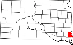 | |
| Towns | ||
| Townships |
| |
| CDP | ||
| Footnotes | ‡This populated place also has portions in an adjacent county or counties | |
| ||
| Authority control |
|
|---|