Hartington, Nebraska
Hartington is a city in Cedar County, Nebraska, United States. The population was 1,554 at the 2010 census.[6] It is the county seat of Cedar County.[7]
Hartington, Nebraska | |
|---|---|
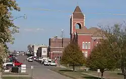 Downtown Hartington; Cedar County Courthouse in right foreground | |
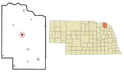 Location of Hartington, Nebraska | |
| Coordinates: 42°37′16″N 97°15′50″W | |
| Country | United States |
| State | Nebraska |
| County | Cedar |
| Area | |
| • Total | 1.00 sq mi (2.59 km2) |
| • Land | 1.00 sq mi (2.59 km2) |
| • Water | 0.00 sq mi (0.00 km2) |
| Elevation | 1,404 ft (428 m) |
| Population | |
| • Total | 1,554 |
| • Estimate (2019)[3] | 1,464 |
| • Density | 1,461.08/sq mi (564.25/km2) |
| Time zone | UTC-6 (Central (CST)) |
| • Summer (DST) | UTC-5 (CDT) |
| ZIP code | 68739 |
| Area code(s) | 402 |
| FIPS code | 31-21275[4] |
| GNIS feature ID | 0829832[5] |
| Website | www |
History
Hartington was platted in 1883, as a water stop on the railroad.[8] It was named for Lord Hartington, who had then recently paid a visit to the U.S.[9][10]
Historic buildings
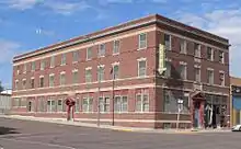
Hartington includes a number of historic buildings. These include three brick structures on the National Register of Historic Places: the Prairie School Hartington City Hall and Auditorium (1921-1923), the Romanesque Revival Cedar County Courthouse (1890-1891), and the Colonial Revival Hartington Hotel (1917).[11]
Geography
Hartington is located at 42°37′16″N 97°15′50″W (42.621027, -97.263953).[12] According to the United States Census Bureau, the city has a total area of 0.94 square miles (2.43 km2), all land.[13]
Demographics
| Historical population | |||
|---|---|---|---|
| Census | Pop. | %± | |
| 1900 | 971 | — | |
| 1910 | 1,413 | 45.5% | |
| 1920 | 1,467 | 3.8% | |
| 1930 | 1,568 | 6.9% | |
| 1940 | 1,688 | 7.7% | |
| 1950 | 1,660 | −1.7% | |
| 1960 | 1,648 | −0.7% | |
| 1970 | 1,581 | −4.1% | |
| 1980 | 1,730 | 9.4% | |
| 1990 | 1,583 | −8.5% | |
| 2000 | 1,640 | 3.6% | |
| 2010 | 1,554 | −5.2% | |
| 2019 (est.) | 1,464 | [3] | −5.8% |
| U.S. Decennial Census[14] | |||
2010 census
At the 2010 census there were 1,554 people, 641 households, and 402 families living in the city. The population density was 1,653.2 inhabitants per square mile (638.3/km2). There were 715 housing units at an average density of 760.6 per square mile (293.7/km2). The racial make-up of the city was 99.2% White, 0.1% African American, 0.2% Native American, 0.1% Asian, 0.1% from other races, and 0.3% from two or more races. Hispanic or Latino of any race were 0.5%.[2]
Of the 641 households 28.4% had children under the age of 18 living with them, 56.5% were married couples living together, 4.4% had a female householder with no husband present, 1.9% had a male householder with no wife present, and 37.3% were non-families. 34.8% of households were one person and 21.3% were one person aged 65 or older. The average household size was 2.34 and the average family size was 3.08.
The median age was 42.6 years. 26.1% of residents were under the age of 18; 6.1% were between the ages of 18 and 24; 19.7% were from 25 to 44; 21.9% were from 45 to 64; and 26.2% were 65 or older. The gender makeup of the city was 49.8% male and 50.2% female.
2000 census
At the 2000 census there were 1,640 people, 670 households, and 416 families living in the city. The population density was 1,821.5 people per square mile (703.6/km2). There were 738 housing units at an average density of 819.7 per square mile (316.6/km2). The racial makeup of the city was 99.15% White, 0.12% Native American, 0.06% from other races, and 0.67% from two or more races. Hispanic or Latino of any race were 0.24%.[4]
Of the 670 households 30.1% had children under the age of 18 living with them, 55.4% were married couples living together, 4.3% had a female householder with no husband present, and 37.9% were non-families. 34.5% of households were one person and 22.1% were one person aged 65 or older. The average household size was 2.36 and the average family size was 3.12.
The age distribution was 27.3% under the age of 18, 6.1% from 18 to 24, 22.4% from 25 to 44, 18.3% from 45 to 64, and 25.9% 65 or older. The median age was 40 years. For every 100 females, there were 96.4 males. For every 100 females age 18 and over, there were 88.0 males.
The median household income was $33,365, and the median family income was $43,897. Males had a median income of $30,848 versus $18,452 for females. The per capita income for the city was $16,133. About 1.7% of families and 6.2% of the population were below the poverty line, including 2.0% of those under age 18 and 11.1% of those age 65 or over.
Notable people
- Ralph G. Brooks - 29th Governor of Nebraska[15]
- Dwight W. Burney, 30th Governor of Nebraska[16]
- Willard H. Burney, member of the Nebraska House of Representatives[17]
- Russ Hochstein, American football guard for the Kansas City Chiefs[18]
- James Lee Rankin, United States Solicitor General 1956-61[19]
- Charles Thone, U.S. Representative 1971–79, governor of Nebraska 1979-83[20]
See also
References
- "2019 U.S. Gazetteer Files". United States Census Bureau. Retrieved July 26, 2020.
- "U.S. Census website". United States Census Bureau. Retrieved 2012-06-24.
- "Population and Housing Unit Estimates". United States Census Bureau. May 24, 2020. Retrieved May 27, 2020.
- "U.S. Census website". United States Census Bureau. Retrieved 2008-01-31.
- "US Board on Geographic Names". United States Geological Survey. 2007-10-25. Retrieved 2008-01-31.
- http://www.yankton.net/articles/2011/03/03/community/doc4d6f181b374f9967268554.txt
- "Find a County". National Association of Counties. Retrieved 2011-06-07.
- "Hartington, Cedar County". Center for Advanced Land Management Information Technologies. University of Nebraska. Retrieved 1 August 2014.
- Fitzpatrick, Lillian L. (1960). Nebraska Place-Names. University of Nebraska Press. p. 34. ISBN 0803250606.
- Chicago and North Western Railway Company (1908). A History of the Origin of the Place Names Connected with the Chicago & North Western and Chicago, St. Paul, Minneapolis & Omaha Railways. p. 159.
- "Nebraska National Register Sites in Cedar County". Lincoln, Nebraska: Nebraska State Historical Society. Retrieved 2011-06-23.
- "US Gazetteer files: 2010, 2000, and 1990". United States Census Bureau. 2011-02-12. Retrieved 2011-04-23.
- "US Gazetteer files 2010". United States Census Bureau. Archived from the original on 2012-01-25. Retrieved 2012-06-24.
- "Census of Population and Housing". Census.gov. Retrieved June 4, 2015.
- "Nebraska Governor Ralph Gilmour Brooks". National Governors Association. Retrieved October 6, 2012.
- "Nebraska Governor Dwight Willard Burney". National Governors Association. Retrieved October 4, 2012.
- "Willard H. Burney (1857-1943)". The Political Graveyard. Retrieved October 6, 2012.
- "Russ Hochstein". NFL Enterprises LLC. Retrieved October 6, 2012.
- "J. Lee Rankin". The United States Department of Justice. Retrieved October 6, 2012.
- "Nebraska Governor Charles Thone". National Governors Association. Retrieved October 6, 2012.
External links
| Wikimedia Commons has media related to Hartington, Nebraska. |
- City of Hartington (Official Site)
- Hartington Chamber of Commerce
- Hartington-Newcastle Public Schools
- Cedar Catholic School
Municipalities and communities of Cedar County, Nebraska, United States | ||
|---|---|---|
| Cities | Map of Nebraska highlighting Cedar County | |
| Villages | ||
| CDPs | ||
| Unincorporated communities | ||
| ||
