Wynot, Nebraska
Wynot is a village in Cedar County, Nebraska, United States. The population was 166 at the 2010 census.[6]
Wynot, Nebraska | |
|---|---|
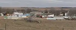 Wynot, seen from the southwest | |
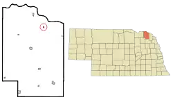 Location of Wynot, Nebraska | |
| Coordinates: 42°44′26″N 97°10′12″W | |
| Country | United States |
| State | Nebraska |
| County | Cedar |
| Area | |
| • Total | 0.18 sq mi (0.48 km2) |
| • Land | 0.18 sq mi (0.48 km2) |
| • Water | 0.00 sq mi (0.00 km2) |
| Elevation | 1,198 ft (365 m) |
| Population | |
| • Total | 166 |
| • Estimate (2019)[3] | 183 |
| • Density | 994.57/sq mi (385.04/km2) |
| Time zone | UTC-6 (Central (CST)) |
| • Summer (DST) | UTC-5 (CDT) |
| ZIP code | 68792 |
| Area code(s) | 402 |
| FIPS code | 31-53905[4] |
| GNIS feature ID | 0834897[5] |
| Website | www |
History
Wynot got its start following construction of the railroad through the territory.[7] According to tradition, it was derived from an old German settler's common answer of "Why not?"[8][9]
Geography
Wynot is located at 42°44′26″N 97°10′12″W (42.740533, -97.169956).[10]
According to the United States Census Bureau, the village has a total area of 0.18 square miles (0.47 km2), all land.[11]
Demographics
| Historical population | |||
|---|---|---|---|
| Census | Pop. | %± | |
| 1910 | 258 | — | |
| 1920 | 368 | 42.6% | |
| 1930 | 348 | −5.4% | |
| 1940 | 416 | 19.5% | |
| 1950 | 233 | −44.0% | |
| 1960 | 209 | −10.3% | |
| 1970 | 226 | 8.1% | |
| 1980 | 222 | −1.8% | |
| 1990 | 213 | −4.1% | |
| 2000 | 191 | −10.3% | |
| 2010 | 166 | −13.1% | |
| 2019 (est.) | 183 | [3] | 10.2% |
| U.S. Decennial Census[12] | |||
2010 census
As of the census[2] of 2010, there were 166 people, 77 households, and 51 families living in the village. The population density was 922.2 inhabitants per square mile (356.1/km2). There were 89 housing units at an average density of 494.4 per square mile (190.9/km2). The racial makeup of the village was 99.4% White and 0.6% from two or more races.
There were 77 households, of which 23.4% had children under the age of 18 living with them, 55.8% were married couples living together, 5.2% had a female householder with no husband present, 5.2% had a male householder with no wife present, and 33.8% were non-families. 31.2% of all households were made up of individuals, and 13% had someone living alone who was 65 years of age or older. The average household size was 2.16 and the average family size was 2.71.
The median age in the village was 50 years. 21.7% of residents were under the age of 18; 1.7% were between the ages of 18 and 24; 19.2% were from 25 to 44; 30.6% were from 45 to 64; and 26.5% were 65 years of age or older. The gender makeup of the village was 48.2% male and 51.8% female.
2000 census
As of the census[4] of 2000, there were 191 people, 83 households, and 52 families living in the village. The population density was 997.8 people per square mile (388.1/km2). There were 90 housing units at an average density of 470.2 per square mile (182.9/km2). The racial makeup of the village was 100.00% White.
There were 83 households, out of which 28.9% had children under the age of 18 living with them, 48.2% were married couples living together, 10.8% had a female householder with no husband present, and 37.3% were non-families. 32.5% of all households were made up of individuals, and 16.9% had someone living alone who was 65 years of age or older. The average household size was 2.30 and the average family size was 3.00.
In the village, the population was spread out, with 26.2% under the age of 18, 6.3% from 18 to 24, 27.2% from 25 to 44, 18.8% from 45 to 64, and 21.5% who were 65 years of age or older. The median age was 40 years. For every 100 females, there were 103.2 males. For every 100 females age 18 and over, there were 101.4 males.
As of 2000 the median income for a household in the village was $27,750, and the median income for a family was $38,750. Males had a median income of $21,389 versus $19,688 for females. The per capita income for the village was $14,937. None of the families and 3.4% of the population were living below the poverty line, including no under eighteens and 16.2% of those over 64.
See also
References
- "2019 U.S. Gazetteer Files". United States Census Bureau. Retrieved July 26, 2020.
- "U.S. Census website". United States Census Bureau. Retrieved 2012-06-24.
- "Population and Housing Unit Estimates". United States Census Bureau. May 24, 2020. Retrieved May 27, 2020.
- "U.S. Census website". United States Census Bureau. Retrieved 2008-01-31.
- "US Board on Geographic Names". United States Geological Survey. 2007-10-25. Retrieved 2008-01-31.
- http://www.yankton.net/articles/2011/03/03/community/doc4d6f181b374f9967268554.txt
- "Wynot, Cedar County". Center for Advanced Land Management Information Technologies. University of Nebraska. Retrieved 1 August 2014.
- Fitzpatrick, Lillian L. (1960). Nebraska Place-Names. University of Nebraska Press. p. 34. ISBN 0803250606.
- Remington, Frank L. (Sep 8, 1969). "Take a Good Look at the US Map. Towns Have the Craziest Names". The Milwaukee Journal. p. 1. Retrieved 18 May 2015.
- "US Gazetteer files: 2010, 2000, and 1990". United States Census Bureau. 2011-02-12. Retrieved 2011-04-23.
- "US Gazetteer files 2010". United States Census Bureau. Archived from the original on February 20, 2011. Retrieved 2012-06-24.
- "Census of Population and Housing". Census.gov. Retrieved June 4, 2015.
External links
Municipalities and communities of Cedar County, Nebraska, United States | ||
|---|---|---|
| Cities | Map of Nebraska highlighting Cedar County | |
| Villages | ||
| CDPs | ||
| Unincorporated communities | ||
| ||