Cedar County, Nebraska
Cedar County is a county in the U.S. state of Nebraska. As of the 2010 United States Census, the population was 8,852.[1] The county seat is Hartington.[2] The county was formed in 1857, and was named for the Cedar tree groves in the area.[3][4][5]
Cedar County | |
|---|---|
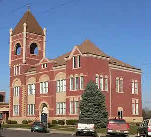 Cedar County Courthouse in Hartington | |
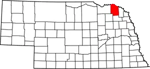 Location within the U.S. state of Nebraska | |
 Nebraska's location within the U.S. | |
| Coordinates: 42°36′N 97°15′W | |
| Country | |
| State | |
| Founded | 1857 |
| Seat | Hartington |
| Largest city | Hartington |
| Area | |
| • Total | 746 sq mi (1,930 km2) |
| • Land | 740 sq mi (1,900 km2) |
| • Water | 5.5 sq mi (14 km2) 0.7%% |
| Population | |
| • Estimate (2018) | 8,446 |
| • Density | 11.5/sq mi (4.4/km2) |
| Time zone | UTC−6 (Central) |
| • Summer (DST) | UTC−5 (CDT) |
| Congressional district | 3rd |
| Website | www |
In the Nebraska license plate system, Cedar County is represented by the prefix 13 (it had the 13th-largest number of vehicles registered in the county when the license plate system was established in 1922).
Geography
Cedar County is on the northern edge of Nebraska. Its north boundary abuts the south boundary line of the state of South Dakota, across the Missouri River. According to the US Census Bureau, the county has an area of 746 square miles (1,930 km2), of which 740 square miles (1,900 km2) is land and 5.5 square miles (14 km2) (0.7%) is water.[6]
Major highways
Adjacent counties
- Clay County, South Dakota - northeast
- Dixon County - east
- Wayne County - southeast
- Pierce County - southwest
- Knox County - west
- Yankton County, South Dakota - northwest
Protected areas
- Audubon Bend Wildlife Area[7]
- Calumet Bluff
- Chalkrock State Wildlife Management Area[8]
- Cottonwood Recreation Area
- Missouri National Recreational River (part)
- Bow Creek Recreation Area[9]
- Meridian Bridge
- Nebraska Tailwaters Recreation Area
- Tatanka State Wildlife Management Area (part)[10]
- Training Dike Recreation Area
- Wiseman State Wildlife Management Area[11]
Lakes
- Chalkrock Lake
- Lewis and Clark Lake (part)
Demographics
| Historical population | |||
|---|---|---|---|
| Census | Pop. | %± | |
| 1860 | 246 | — | |
| 1870 | 1,032 | 319.5% | |
| 1880 | 2,899 | 180.9% | |
| 1890 | 7,028 | 142.4% | |
| 1900 | 12,467 | 77.4% | |
| 1910 | 15,191 | 21.8% | |
| 1920 | 16,225 | 6.8% | |
| 1930 | 16,427 | 1.2% | |
| 1940 | 15,126 | −7.9% | |
| 1950 | 13,843 | −8.5% | |
| 1960 | 13,368 | −3.4% | |
| 1970 | 12,192 | −8.8% | |
| 1980 | 11,375 | −6.7% | |
| 1990 | 10,131 | −10.9% | |
| 2000 | 9,615 | −5.1% | |
| 2010 | 8,852 | −7.9% | |
| 2018 (est.) | 8,446 | [12] | −4.6% |
| US Decennial Census[13] 1790-1960[14] 1900-1990[15] 1990-2000[16] 2010-2013[1] | |||
As of the 2000 United States Census[17] there were 9,615 people, 3,623 households, and 2,565 families in the county. The population density was 13 people per square mile (5/km2). There were 4,200 housing units at an average density of 6 per square mile (2/km2). The racial makeup of the county was 99.07% White, 0.10% Black or African American, 0.20% Native American, 0.04% Asian, 0.01% Pacific Islander, 0.18% from other races, and 0.40% from two or more races. 0.43% of the population were Hispanic or Latino of any race. 69.8% were of German and 5.1% American ancestry.
There were 3,623 households, out of which 34.80% had children under the age of 18 living with them, 63.60% were married couples living together, 4.30% had a female householder with no husband present, and 29.20% were non-families. 27.00% of all households were made up of individuals, and 15.70% had someone living alone who was 65 years of age or older. The average household size was 2.60 and the average family size was 3.20.
The county population contained 29.40% under the age of 18, 6.00% from 18 to 24, 24.20% from 25 to 44, 20.30% from 45 to 64, and 20.00% who were 65 years of age or older. The median age was 39 years. For every 100 females there were 100.10 males. For every 100 females age 18 and over, there were 97.10 males.
The median income for a household in the county was $33,435, and the median income for a family was $39,422. Males had a median income of $26,707 versus $18,370 for females. The per capita income for the county was $15,514. About 6.30% of families and 9.10% of the population were below the poverty line, including 10.70% of those under age 18 and 9.70% of those age 65 or over.
Communities
Cities
- Hartington (county seat)
- Laurel
- Randolph
Census-designated places
Unincorporated communities
Politics
Cedar County voters are strongly Republican. In only one national election since 1936 has the county selected the Democratic Party candidate (as of 2016).
| Year | Republican | Democratic | Third Parties |
|---|---|---|---|
| 2016 | 79.9% 3,532 | 12.9% 571 | 7.2% 317 |
| 2012 | 75.6% 3,278 | 22.1% 958 | 2.3% 98 |
| 2008 | 69.8% 2,912 | 28.5% 1,190 | 1.7% 72 |
| 2004 | 74.7% 3,387 | 23.9% 1,083 | 1.5% 66 |
| 2000 | 70.0% 2,989 | 24.9% 1,062 | 5.1% 218 |
| 1996 | 52.2% 2,171 | 29.3% 1,218 | 18.5% 770 |
| 1992 | 43.9% 1,981 | 22.3% 1,007 | 33.9% 1,530 |
| 1988 | 58.1% 2,462 | 41.5% 1,759 | 0.4% 17 |
| 1984 | 72.7% 3,298 | 26.5% 1,201 | 0.8% 37 |
| 1980 | 67.1% 3,259 | 26.0% 1,265 | 6.9% 334 |
| 1976 | 50.7% 2,415 | 46.7% 2,225 | 2.5% 120 |
| 1972 | 62.4% 2,995 | 37.6% 1,807 | |
| 1968 | 61.5% 2,853 | 31.1% 1,444 | 7.3% 340 |
| 1964 | 42.6% 2,299 | 57.5% 3,104 | |
| 1960 | 51.0% 3,060 | 49.0% 2,939 | |
| 1956 | 64.7% 3,809 | 35.3% 2,078 | |
| 1952 | 77.0% 4,753 | 23.0% 1,417 | |
| 1948 | 50.4% 2,616 | 49.6% 2,578 | |
| 1944 | 66.3% 3,616 | 33.7% 1,839 | |
| 1940 | 62.7% 4,397 | 37.3% 2,619 | |
| 1936 | 35.2% 2,394 | 55.7% 3,781 | 9.1% 618 |
| 1932 | 25.2% 1,696 | 74.0% 4,981 | 0.8% 55 |
| 1928 | 49.6% 3,206 | 50.1% 3,241 | 0.3% 20 |
| 1924 | 39.9% 2,441 | 28.6% 1,747 | 31.5% 1,927 |
| 1920 | 74.5% 3,906 | 24.4% 1,279 | 1.1% 58 |
| 1916 | 49.5% 1,727 | 49.1% 1,715 | 1.4% 49 |
| 1912 | 21.7% 716 | 45.9% 1,511 | 32.4% 1,067 |
| 1908 | 47.8% 1,627 | 50.9% 1,732 | 1.3% 44 |
| 1904 | 59.4% 1,797 | 33.8% 1,023 | 6.8% 207 |
| 1900 | 47.4% 1,441 | 51.4% 1,565 | 1.2% 37 |
See also
| Wikimedia Commons has media related to Cedar County, Nebraska. |
External links
References
- "State & County QuickFacts". US Census Bureau. Archived from the original on July 8, 2011. Retrieved September 17, 2013.
- "Find a County". National Association of Counties. Archived from the original on 31 May 2011. Retrieved 7 June 2011.
- Fitzpatrick, Lilian Linder (1925). Nebraska Place-Names. Lincoln: University of Nebraska Studies in Language, Literature, and Criticism. p. 33. Retrieved December 18, 2014.
- Andreas, A. T. (1882). "Andreas' History of the State of Nebraska". The Kansas Collection. Archived from the original on 2003-05-08. Retrieved December 18, 2014.
- "Cedar County". Nebraska Association of County Officials. Retrieved December 18, 2014.
- "2010 Census Gazetteer Files". US Census Bureau. August 22, 2012. Archived from the original on November 13, 2013. Retrieved December 6, 2014.
- NE Google Maps (accessed 10 February 2019)
- NE Google Maps (accessed 17 January 2019)
- NE Google Maps(accessed 10 February 2019)
- NE Google Maps (accessed 17 January 2019)
- NE Google Maps (accessed 17 January 2019)
- "Population and Housing Unit Estimates". Retrieved December 26, 2019.
- "US Decennial Census". US Census Bureau. Retrieved December 6, 2014.
- "Historical Census Browser". University of Virginia Library. Retrieved December 6, 2014.
- "Population of Counties by Decennial Census: 1900 to 1990". US Census Bureau. Retrieved December 6, 2014.
- "Census 2000 PHC-T-4. Ranking Tables for Counties: 1990 and 2000" (PDF). US Census Bureau. Retrieved December 6, 2014.
- "U.S. Census website". US Census Bureau. Retrieved 31 January 2008.
- Election Results
Places adjacent to Cedar County, Nebraska | ||||||||||
|---|---|---|---|---|---|---|---|---|---|---|
| ||||||||||
Municipalities and communities of Cedar County, Nebraska, United States | ||
|---|---|---|
| Cities | Map of Nebraska highlighting Cedar County | |
| Villages | ||
| CDPs | ||
| Unincorporated communities | ||
| ||
