Haveri
Haveri is a City in Karnataka, India, It is the administrative headquarters of Haveri District.[1] The name Haveri is derived from the Kannada words haavu and keri, which means place of snakes. Haveri is famous for its cardamom garlands. It is said that Haveri had around 1000 mathas (sacred religious places; Kannada - ಮಠ) in ancient days. One of the famous mathas is Hukkeri Math. Haveri is also famous for marketing Byadagi red chillies, which are well known all over India. Around 25 km away, there is a place called Bada which is the birthplace of the poet Kanakadasa.
- For the village in Azerbaijan, see Hovari.
Haveri | |
|---|---|
CMC | |
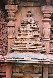
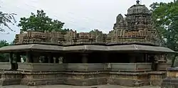 Siddheshwara Temple at Haveri | |
| Nickname(s): Yalakki Kampina Nadu | |
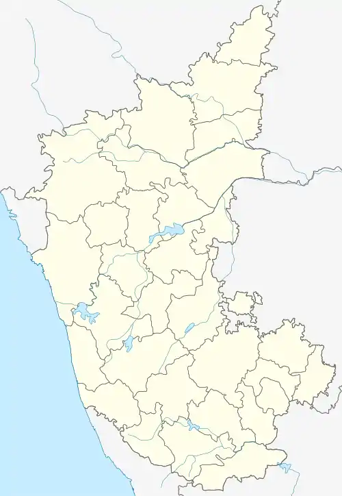 Haveri Location in Karnataka, India | |
| Coordinates: 14°47′38″N 75°24′14″E | |
| Country | |
| State | |
| Region | Bayaluseeme |
| District | Haveri district |
| Area | |
| • Total | 26.19 km2 (10.11 sq mi) |
| Elevation | 571 m (1,873 ft) |
| Population | |
| • Total | 67,102 |
| • Density | 2,134.89/km2 (5,529.3/sq mi) |
| Languages | |
| • Official | Kannada ಕನ್ನಡ |
| Time zone | UTC+5:30 (IST) |
| PIN | 581 110 |
| Telephone code | 08375 |
| Vehicle registration | KA-27 |
Haveri is 7 hours away from Bengaluru by train. It is the middle way stop between Hubli and Davanagere. It is the stop 76.5 km before Hubli and 72 km after Davanagere. By road, it is about 340 km from Bengaluru on NH-48 towards Mumbai. It is located 307 km north of the port city Mangalore.
Haveri nickname- Yalakki Kampina Nadu.
Haveri have medium stage in education. Haveri has a Government Engineering College at Devagiri started in the year 2007.
History of Haveri
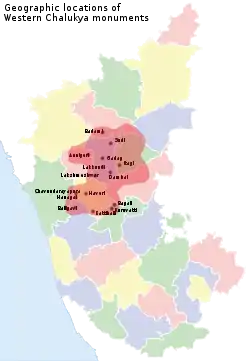
Core area of Western Chalukya monuments includes the places Badami, Sudi, Annigeri, Mahadeva Temple (Itagi), Gadag, Lakkundi, Lakshmeshwar, Dambal, Haveri, Bankapura, Rattahalli, Kuruvatti, Bagali, Balligavi, Chaudayyadanapura, Galaganatha, Hangal. It was possible because Soapstone is found in abundance in these areas. Haveri also comes under Core area of Western Chalukya architectural activity.
History of Haveri district dates to pre-historic period. About 1300 stone writings of different rulers like Chalukyas, Rastrakutas are found in the district. Bankapura Challaketaru, Guttavula Guttaru, Kadambas of Hangal and Nurumbad are some of the well known Samanta Rulers. Devendramunigalu the teacher of Kannada Adikavi Pampa and Ajitasenacharya the teacher of Ranna Chavundaraya lived in Bankapura. This was also the second capital of Hoysala Vishnuvardhana. Guttaru ruled during latter part of the 12th century and up to end of the 13th century from Guttavol (Guttal) village as Mandaliks of Chalukya, independently for some time and as Mandaliks of Seunas of Devagiri. Shasanas found in Chaudayyadanapura (Choudapur), a village near Guttal, reveal that Mallideva was Mandalika of 6th Vikramaditya of Chalukyas. Jatacholina, under the leadership of Mallideva built the Mukteshwara temple at Chaudayyadanapura (Choudapur).
Kadambas of Nurumbad during the period of Kalyani Chalukyas ruled about 100 villages with Rattihalli as their capital.
The district is proud to be the birthplace of Santa Shishunala Sharif, the great Saint Kanakadasaru, Sarvajnya, Hanagal Kumara Shivayogigalu, Wagish Panditaru, Writer Galaganatharu, Ganayogi Panchakshari Gavayigalu, Gnyana Peetha Awardee Dr.V.K.Gokak and many more. The freedom fighters Mailara Mahadevappa and Gudleppa Hallikere.
Tourist attractions of Haveri

The centre of Western Chalukya architectural developments was the region including present-day Bagalkot, Gadag, Koppal, Haveri and Dharwad districts;
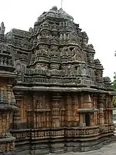
Siddheshwara temple at Haveri a staggered square plan with dravida articulation and superstructure, 11th century CE. Miniature decorative dravida and nagara style towers at Siddheshvara Temple in Haveri
- Basavanna Temple
- Utsav Rock Garden is situated at Gotagodi on NH-4 Shiggaon Taluk. It is blended with both modern and art where more than 1000 real life size sculptures are present. It has got 8 world records. It is a unique garden in the whole world.
Places of interest in Haveri district
Temples
- Siddheshwara temple at Haveri
Mosques/ Sufi Places
- Dargah Of Irshad Ali Baba, P.B. Road, Haveri.
Churches
- St Anne's Church at Hangal Road, Bharathi Nagar, Haveri
Mini Vidhana Soudha
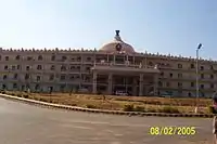
Recently, a Mini Vidhana Soudha was constructed on Devagiri hill. The Mini Vidhana Soudha hosts major government offices. The main office among these is the District Commissioner's office.
Geography
Haveri is located at 14.8°N 75.4°E.[3] It has an average elevation of 572 metres (1876 feet).
Educational institutes
The masters' Shri Rajiv Gandhi Karnataka University P G Centre, Kerimattihalli, Haveri is the developing educational institution. There are three major colleges in Haveri. One is Govt. First Grade College, Gudleppa Hallikeri College, and C. B. Kolli Polytechnic. Among other colleges are S. S. Women's Degree College, SJM Pre-University College, and SMS Pre-University College. Recently Govt. Engineering College was started. C.B.Collipolytechnic
CBSE Schools
- Karnataka Public School, Hanagal Road, Haveri
- K.L.E's English Medium CBSE School (www.klescbsehvr.org)
Convent Schools
- Mrutyunjaya Vidya Peetha's Haunsabhavi. Since 1918 (from convent to Degree also top 1 College Diploma)
- Sri Vivekananda Convent School Tumminakkati
- New Cambridge Convent School Tumminakatti
High schools
- Durgad High School Haunsabhavi, Mrutyunjaya Vidya Peetha's Haunsabhavi. Since 1918 (from convent to Degree also top 1 College Diploma)
- Karnataka Public School, Hanagal Road, Haveri
- K.L.E's English Medium CBSE School (www.klescbsehvr.org)
- Gandhi Grameena Gurukula Hosarithi
- Lions English Medium School
- St. Michael English Medium School
- J. G. S. S. High School (Geleyara Balaga)
- J. P. Rotary School
- Hukkerimath Shivabasaveshwar High School
- S M S Girls High School
- H.L.V. English Medium School Savanur
- Mrutyunjaya High School Kurubagonda
- Shri Kalidasa High School, Kaginele bus stand, Haveri
- S J M Primary and High School, Haveri
- St. Anne's English Medium School. Haveri
- S V S high school Abalur
- Sri Sangana Basaveshwara High School, Tumminakatti
- Govt High School Tumminakatti
- Govt High School, Tumminakatti
- Sir M Vishweshwaraiah School, Haveri
- H.P.S Kalagonda, Byadgi taluk
Colleges and places
- , MASC college, Rural Polytechnic Diploma, Mrutyunjaya Vidya Peetha's Haunsabhavi. Since 1918 (from convent to Degree also top 1 College Diploma)
- Gudleppa Hallikeri College (popularly known as GH College)(Science, Commerce and Arts)
- Parivartana PU Science and Commerce College
- C B Kolli Polytechnic (CS, E&C, Mech, Civil and IS)
- Govt. Engg. College (CS, E&C, Mech. and Civil)
- Govt. Majeed College Savanur
- S.J.M PU College, Haveri (Science, Commerce and Arts)
- Sri Sangana Basaveshwara PU College, Tumminakatti
- Sri Hukkerimata Shivabasaveshwar High School Haveri
- Government First Grade College, Haveri
- Government Women's First Grade College, Haveri
- Lions English Girls Commerce College, Haveri
- Swami Vivekananda PU College Haveri
- College of Horticultural Engineering and Food Technology, Devihosur, Haveri
Demographics
As of 2011 India census,[4] Haveri had a population of 67102. Males constitute 51% of the population and females 49%. Haveri has an average literacy rate of 70%, higher than the national average of 59.5%: male literacy is 76%, and female literacy is 64%. In Haveri, 13% of the population is under 6 years of age.
See also
References
- "Karnataka, The Tourist Paradise". Archived from the original on 4 March 2009. Retrieved 17 October 2008.
- "JSTOR: Sculptures from the Later Calukyan Temple at Haveri". 31: 167–178. JSTOR 3249429. Cite journal requires
|journal=(help) - Falling Rain Genomics, Inc - Haveri
- "Census of India 2011: Data from the 2011 Census, including cities, villages and towns (Provisional)". Census Commission of India. Archived from the original on 16 June 2004. Retrieved 1 November 2008.
| Wikimedia Commons has media related to Haveri. |
