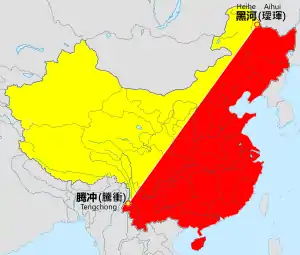
Heihe–Tengchong Line
The Heihe–Tengchong Line (simplified Chinese: 黑河–腾冲线; traditional Chinese: 黑河–騰衝線; pinyin: Hēihé–Téngchōng xiàn), also called the Aihui-Tengchong Line (and internationally as the Hu line) is an imaginary line that divides the area of China into two roughly equal parts with contrasting population densities. It stretches from the city of Heihe in northeast to Tengchong in south, diagonally across China. The eastern half, area shown in red in the map, is further subdivided into north and south halves.
History
Chinese population geographer Hu Huanyong imagined the line in 1935 and called it a "geo-demographic demarcation line". As this line was proposed in 1935, the map of China would have included Mongolia (whose independence China did not recognise until after WWII) but excluded Taiwan (which China recognised as being an integral part of Japan at the time).
Demographic trend
1935 statistics
This imaginary line divides the territory of China as follows (going by 1935 statistics):
- West of the line: 64% of the area, but only 4% of the population (1935)
- East of the line: 36% of the area, but 96% of the population (1935)
2002 and 2015 statistics
Despite a large scale urban migration mainly towards coasts but also trending south, 2002 and 2015 statistics remain nearly identical vis-à-vis the line:
- West of the line: 57% of the area, but only 6% of the population (2002)[1]
- East of the line: 43% of the area, but 94% of the population (2002)[1]
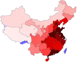
The minor change in total population percent from 1935 to 2015 is attributed to Han Chinese migration to urban areas in the autonomous regions of Tibet and Xinjiang, as well as one-child policy restrictions on the majority, with exceptions for largely-minority groups west of the line. However, during the 2000-2015 period, population in the west of the line indeed grew faster than the east, but the growth wasn't sufficient to budge the rounded percentages. Most of this growth was contained in the cities of Ürümqi, Lanzhou, Ordos, and Yinchuan, although some tribal non-city areas also registered high growth. After 80 years, the area west of the Heihe–Tengchong Line remains relatively rural, rugged or inhospitable, underdeveloped and poor as compared to the east. [2]
See also
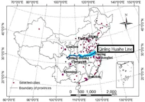
- Qinling-Huaihe Line, further subdivides eastern China in northern and southern halves
References
- Naughton, Barry (2007). The Chinese Economy: Transitions and Growth. Cambridge, Massachusetts: MIT Press. pp. 18–19. ISBN 978-0-262-14095-9.
- W, She (15 August 1998), "Hu Huanyong: father of China's population geography", China Population Today, 15 (20): 20, PMID 12294257
