Hennessey Fire
The Hennessey Fire was a wildfire burning in Napa, Lake, Solano, Yolo and Colusa Counties in California in the United States. The fire was started by a lightning strike on August 17, 2020 in the Vaca Mountains in Rutherford in Napa County. The Hennessey Fire was the largest of a complex of fires, known as the LNU Lightning Complex, all of which were caused by the impact of Tropical Storm Fausto, which fueled a thunderstorm moving through the area during a heat wave. The fire has burned 317,909 acres (128,653 ha) and is now 100 percent contained as of October 2020. The fire has resulted in mandatory evacuations, including of wineries and residences. It currently does not threaten any structures and has destroyed 633 structures and damaged 179, including homes. Four people were killed in the Hennessey Fire.
| Hennessey Fire (LNU Complex fires) | |
|---|---|
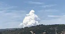 Hennessey Fire on August 18 as seen from Sonoma, California | |
| Location | Vaca Mountains, Rutherford, Napa County California, United States |
| Coordinates | 38.495°N 122.35043°W |
| Statistics[1][2] | |
| Date(s) | August 17, 2020– |
| Burned area | 317,909 acres (128,653 ha) |
| Cause | Lightning strike |
| Buildings destroyed |
|
| Deaths |
|
| Livestock losses | 4 |
| Non-fatal injuries |
|
| Evacuated | Over 17,000 |
| Map | |
 Location in California | |
By itself, the Hennessey Fire is the seventh-largest wildfire ever recorded in California, and the largest fire ever in Napa County.[3]
Events
August
The fire, which was first called the 14-3 Fire, was first reported burning near Hennessey Ridge Road in Rutherford, California in Napa County around 6:42 AM on August 17, 2020. The fire was started by a lightning strike during a series of thunderstorms traveling through Northern California as a result of Tropical Storm Fausto. Initially it was only 20 acres (8.1 ha) large.[4] However, dry conditions and strong, gusty winds throughout the morning of August 17 caused the fire to explode to 750 acres and then to 2,400 acres (971 ha) by 5 PM,[5] promting evacuations for parts of Chiles Valley and the area near Lake Hennessey.[6] The next day, August 18, CAL FIRE announced that one house and two outbuildings had been destroyed and evacuations for Butts Canyon and Snell Valley, including communities on the east coast of Lake Berryessa, were announced.[6][7] That night, Hennessey had burned 10,000 acres (4,047 ha) and was not contained. Additional fires had started in Napa County on August 17: the Gamble, Markley, Spanish, and 15-10 Fires - all part of the LNU Lightning Complex.[6]
Additional evacuations continued on August 19 as the fire grew, including unincorporated areas of Napa, Howell Mountain, Angwin, Deer Park, and Aetna Springs. That same day, evacuations were put in place for areas of southeastern Lake County resulting from the Aetna Fire, burning in Aetna Springs and near the Lake County border. That day, the Hennessey Fire had absorbed the five other fires in the area: Gamble, Green, Markley, Spanish Fire and Morgan Fire, encompassing 105,000 acres (42,492 ha) and collectively destroying 105 structures and damaging 70.[6] After merging with Markley, the Hennessey fire zone had expanded to Vacaville and Fairfield, resulting in additional evacuations. By 4 PM, the fire had crossed Interstate 80, resulting in the interstate's closure, and Travis Air Force Base was evacuated. By 9 PM, the fire was quelled near I-80 and the interstate was reopened.[8] Additionally, a Pacific Gas and Electric Company employee was found unresponsive in their vehicle, transported to a hospital and declared dead. Four civilians were also reported injured by CAL FIRE.[6]
By the evening of August 20, CAL FIRE reported that four civilians had died, specifically three in Napa and one in Solano County. That same day, the Hennessey had merged with the Round Fire in southern Lake County, growing the size of the fire to 192,000 acres (77,700 ha). Extreme fire behavior and long range spotting by the fire kept it challenging for firefighters.[6] The Hennessey was declared 15 percent contained by CAL FIRE on August 21, the first progress in fire containment.[9] The next day, the National Weather Service stated that another lightning storm threatened the area.[10] It did not come to fruition, with the Red Flag Warning put in place being canceled, on the 21st, before it was set to expire.[11]
Hennessey had grown to over 200,000 acres (80,937 ha) by August 23. Containment progress was made on the eastern and south sides of the fire, encompassing the portion where the fire burned in Solano County.[12] The following day, residents on Atlas Peak and other unincorporated areas of Napa were allowed to return to their homes.[13] Weather conditions improved, enabling crews to gain further containment, with dozer lines expanding, more hand crews arriving and air support continuing, specifically on the southern, easter and western flanks.
By August 26, the northern flank was the most active, spreading further into Lake County, just south of Middletown,[14] and over the Yolo County line towards Colusa County, crossing Highway 16, resulting in more evacuations, including Guenoc. The California National Guard was called in to serve as hand crews, working alongside firefighters to contain the fire.[15] Approximately 4,000 residents of Angwin were allowed to re-populate on August 28, along with the reopening of St. Helena Hospital. Evacuation orders were lifted for Deer Park on the 27th.[2]
September
As of September 2, 2020, the Hennessey Fire is 317,909 acres (128,653 ha) and 75 percent contained.[6]
Impact
The Hennessey Fire destroyed homes, farms, ranches and additional property in four counties. Over 17,000 people were evacuated. Air quality was heavily impacted for weeks in the San Francisco Bay Area. The fire also interrupted tourism season in wine country and the wine grape harvest in Napa, Lake and Solano Counties.
Evacuations and closures
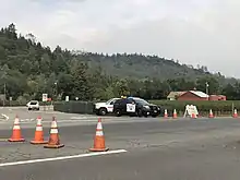
Hennessey Fire resulted in evacuations in five Northern California counties: Napa, Lake, Solano, Yolo and Colusa. An estimated 17,000 residents in Napa County were evacuated.[2] Napa County evacuations included parts of Napa Valley's Wine Country, homes, and resorts and neighborhoods around Lake Berryessa, including Aetna Springs, Angwin, Snell Valley, Atlas Peak, Chiles Valley, Steele Canyon, Pope Valley, Deer Park, Howell Mountain, and unincorporated areas of Napa.[6] The fire also resulted in the evacuation of 51 patients from St. Helena Hospital.[16] Eventually, the fire moved closer to Lake County, resulting in evacuations in Hidden Valley Lake, Jerusalem Valley, and Guenoc.[6][17] Portions of Vacaville and Fairfield in Solano County, California and Yolo & Colusa County were also evacuated.[6][15]
The fire also resulted in major road closures throughout the fire region, including the Interstate 80, which is crossed during rush hour, the Silverado Trail, Highway 128 and Highway 121.[6][8]
Structural and economic impact
The Hennessey Fire has destroyed 633 structures and damaged 943 in Napa, Yolo and Solano Counties.[6] Of those structures destroyed, 254 were single-family homes in Napa County and 280 were in Solano County.[18] The fire destroyed the majority of mobile homes in the Spanish Flat Mobile Villa in Spanish Flat, leaving only a handful of structures standing.[16] The fire also destroyed many homes in Berryessa Highlands.[19]
The fire also impacted agricultural communities near Vacaville, including an olive farm. Numerous livestock was lost in the fire.[20] At least 6,000 acres (2,428 ha) of rangeland was destroyed near Lake Berryessa, resulting in loss land for feeding cattle, requiring ranchers to purchase food.[21]
Air quality
The fire impacted air quality throughout the San Francisco Bay Area, triggering Spare the Air days.[10] Due to the COVID-19 pandemic, a shortage of N95 masks resulted in many farmworkers not having access to appropriate masks to work in poor air conditions. Appropriate protective masks are required to be provided to farmworkers by employers when the air quality is poor. The California Department of Food and Agriculture acquired 1 million N95 masks from the California Office of Emergency Services state stockpile to distribute to farmworkers.[21]
Fatalities
Five people died in the Hennessey Fire. On August 19, a Pacific Gas & Electric employee was found unresponsive in his vehicle in Gates Canyon in Solano County. CPR was performed and he was transported to a local hospital where he was pronounced dead. The employee had been clearing infrastructure in the Gates Canyon area.[6]
Additionally, three individuals died in Napa, burned to death in a house.[16][22] An additional civilian in Solano County was also killed in the fire.[6]
References
- "Hennessey Fire Information". CAL FIRE. Retrieved 17 August 2020.
- Courtney, Kevin (28 August 2020). "Update: Angwin evacuation lifted; St. Helena Hospital reopens Saturday". Napa Valley Register. Retrieved 29 August 2020.
- Eberling, Barry (23 September 2020). "Severe weather helped make Napa's Hennessey Fire one for the record books". Napa Valley Register. Retrieved 10 October 2020.
- Hay, Jeremy (17 August 2020). "St. Helena fire prompts evacuation orders". sfbayca.com. Bay City News. Retrieved 11 October 2020.
- Carter, Lori A. (17 August 2020). "Evacuation orders issued for residents near Hennessey fire in Napa County". Press Democrat. Retrieved 14 October 2020.
- "CAL FIRE LNU Lightning Complex Fire Tweets". Twitter. CAL FIRE. Retrieved 29 August 2020.
- "UPDATE: Hennessey Fire In Napa County Grows To 2,500 Acres; Evacuations Near Lake Berryessa". KPIX 5 CBS. 17 August 2020. Retrieved 29 August 2020.
- Anthony, Laura; Glover, Julian (19 August 2020). "Hennessey Fire: I-80 reopens in Fairfield after wildfire forced closure". ABC7 San Francisco. Retrieved 29 August 2020.
- Graff, Amy; Ting, Eric (21 August 2020). "LNU Complex grows to 302,388 acres, 15% contained". SFGate. Retrieved 29 August 2020.
- Yune, Howard (22 August 2020). "Update: Wildfires spread to 325,000 acres in Napa County and North Bay; lightning to heighten fire risk". Napa Valley Register. Retrieved 29 August 2020.
- Barmann, Jay (24 August 2020). "Red Flag Warning Called Off and Firefighters Make Steady Progress Containing Three Major Wildfires". SFist - San Francisco News, Restaurants, Events, & Sports. Retrieved 29 August 2020.
- Larson, Elizabeth (23 August 2020). "Smoke challenges firefighters on LNU Lightning Complex". Lake County News. Retrieved 29 August 2020.
- Courtney, Kevin. "Update: Cal Fire begins lifting some evacuation orders in Napa County". Napa Valley Register (24 August 2020). Retrieved 29 August 2020.
- "Crews Focusing On Northern End Of Hennessey Fire Wednesday". SFGate. 26 August 2020. Retrieved 29 August 2020.
- "LNU Lightning Complex: Focus Moves To Hennessey, Walbridge Fires; Evacuees Returning; National Guard Arriving". KPIX 5 CBS SF BayArea. 26 August 2020. Retrieved 29 August 2020.
- Barber, Phile (21 August 2020). "Good news, grave concern overlap as Hennessey fire ravages Napa County". Santa Rosa Press Democrat. Retrieved 29 August 2020.
- Fixler, Kevin (27 August 2020). "Firefighters battle flames in Lake County as Hennessey fire sprawls north". Santa Rosa Press Democrat. Retrieved 29 August 2020.
- Courtney, Kevin (1 September 2020). "Cal Fire releases tally of destroyed Napa County homes". Napa Valley Register. Retrieved 2 September 2020.
- Clifford, Charles (25 August 2020). "Residents return home to find destruction after fleeing Hennessey Fire in Napa County". KRON4. Retrieved 29 August 2020.
- Arcuni, Peter (24 August 2020). "Caretaker Returns to Solano County Fire-Ravaged Farm: 'Like a War Zone'". KQED. Retrieved 29 August 2020.
- Hecteman, Kevin (26 August 2020). "Widespread fires char farmland, range, pastures". www.agalert.com. Retrieved 29 August 2020.
- Klearman, Sarah (24 August 2020). "Family identifies, remembers 3 victims claimed by Hennessey Fire". Napa Valley Register. Retrieved 29 August 2020.
External links
| Wikimedia Commons has media related to Hennessey Fire. |
