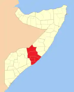
Hirshabelle State
Hirshabelle State is an autonomous region in south-central Somalia. It is bordered by Galmudug to the north, South West State of Somalia and Banadir region to the south, Ethiopia to the west and the Indian Ocean to the east. Jowhar is the capital of Hirshabelle.
Hirshabelle State of Somalia
| |
|---|---|
 Flag | |
 | |
| Capital | Jowhar 04°44′09″N 045°12′13″E |
| Largest city | Jowhar |
| Official languages |
|
| Government | Autonomous presidential democracy |
| Ali Abdullahi Hussein | |
| Yusuf Ahmed Hagar | |
| Autonomous State within Somalia | |
• Established | 9 October 2016 |
| Population | |
• 2020 estimate | 4,771,636 |
• Census | 2020 |
| Currency | Somali shilling (SOS) |
| Time zone | UTC+3 (EAT) |
| UTC+3 (not observed) | |
| Driving side | right |
| Calling code | +252 (Somalia) |
| ISO 3166 code | SO |
| Internet TLD | .so |
Hirshabelle consists of regions Hiran and Middle Shabelle in Somalia. The name of the state comes from combining their names. Hirshabelle proclaimed itself the autonomous state of the Federal Republic of Somalia as stipulated in the provisional Constitution of Somalia.
History
The creation of the Hirshabelle State has long been controversial, as both regions, Hiran and Middle Shabelle, have expressed a desire to create their own separate regional states.
In October 2016, local presidential elections were held, which were won by Abdi Abdullahi Osoble.[1] On 11 March 2017, the Hirshabelle Parliament approved a new Cabinet of 52 Ministers. In September 2017, the Parliament elected a new President, Mohamed Abdi Ware.[2] However, the new government is largely based in Mogadishu, and its authority is limited to only certain parts of the Middle Shabelle region and the city of Jowhar.
The Berghof Foundation wrote in 2017 that “the president of Hirshabelle belongs to the Abgaal and his vice-president to the Hawadle which are both a subclan of Mudulood and Larger Hawiye clan”.[3]
Population
| Region | Population |
|---|---|
| Hiran | 1,514,901 |
| Middle Shabelle | 901,183 |
| Total | 2,416,084 |
Districts of Hiran Region
| District | Population |
|---|---|
| Beledweyne | 544,345 |
| Buloburde | 189,120 |
| Farlibaax | 20207 |
| Ceelcade | 21,712 |
| Jalalaqsi | 96,724 |
| Mahas | 58,918 |
| Mataban | 54,789 |
| Buqdaaqable | 29,386 |
Transport
The road that passes through Jowhar and connects the cities of Jalalaqsi and Mogadishu is considered relatively safe. The road from Jalalaqsi to Buloburde serves as a supply route for the city of Buloburde, but may be subject to attacks by Al-Shabaab. The road from Bulobarde through the Halgan village in Beledwayne passes through Al-Shabab territory, and is therefore more susceptible to attacks by the group. At the same time, the movement of civil transport can be carried out through the territory of Al-Shabaab.
Climate
In March and April, the average daily maximum temperature in Beledweyne, the capital of Hiraan, is 36.7 °C (98.1 °F). In December, the average daily maximum temperature is 21.9 °C (71.4 °F).
| Climate data for Beledweyne, Somalia | |||||||||||||
|---|---|---|---|---|---|---|---|---|---|---|---|---|---|
| Month | Jan | Feb | Mar | Apr | May | Jun | Jul | Aug | Sep | Oct | Nov | Dec | Year |
| Record high °C (°F) | 41.5 (106.7) |
42.5 (108.5) |
43.0 (109.4) |
43.0 (109.4) |
41.3 (106.3) |
39.0 (102.2) |
39.0 (102.2) |
39.0 (102.2) |
40.2 (104.4) |
45.0 (113.0) |
40.0 (104.0) |
42.0 (107.6) |
45.0 (113.0) |
| Average high °C (°F) | 34.5 (94.1) |
35.4 (95.7) |
36.7 (98.1) |
36.9 (98.4) |
34.9 (94.8) |
34.0 (93.2) |
33.0 (91.4) |
33.8 (92.8) |
35.3 (95.5) |
34.4 (93.9) |
34.8 (94.6) |
34.5 (94.1) |
34.8 (94.6) |
| Daily mean °C (°F) | 28.2 (82.8) |
28.7 (83.7) |
30.0 (86.0) |
30.4 (86.7) |
29.2 (84.6) |
28.4 (83.1) |
27.8 (82.0) |
27.7 (81.9) |
29.0 (84.2) |
28.7 (83.7) |
28.5 (83.3) |
28.5 (83.3) |
28.7 (83.7) |
| Average low °C (°F) | 22.0 (71.6) |
22.0 (71.6) |
23.4 (74.1) |
23.9 (75.0) |
23.4 (74.1) |
22.8 (73.0) |
22.6 (72.7) |
21.6 (70.9) |
22.7 (72.9) |
22.6 (72.7) |
22.3 (72.1) |
22.3 (72.1) |
22.6 (72.7) |
| Record low °C (°F) | 16.0 (60.8) |
16.5 (61.7) |
17.0 (62.6) |
16.0 (60.8) |
18.0 (64.4) |
17.0 (62.6) |
17.0 (62.6) |
16.3 (61.3) |
17.2 (63.0) |
17.0 (62.6) |
15.0 (59.0) |
15.0 (59.0) |
15.0 (59.0) |
| Average precipitation mm (inches) | 0 (0) |
1 (0.0) |
5 (0.2) |
48 (1.9) |
59 (2.3) |
6 (0.2) |
3 (0.1) |
3 (0.1) |
8 (0.3) |
51 (2.0) |
16 (0.6) |
5 (0.2) |
204 (8.0) |
| Average precipitation days (≥ 1.0 mm) | 0 | 0 | 0 | 5 | 5 | 0 | 0 | 0 | 0 | 4 | 2 | 0 | 20 |
| Average relative humidity (%) | 58 | 57 | 57 | 60 | 64 | 61 | 65 | 64 | 59 | 64 | 63 | 62 | 61 |
| Mean monthly sunshine hours | 288.3 | 276.9 | 288.3 | 243.0 | 272.8 | 249.0 | 201.5 | 232.5 | 246.0 | 223.2 | 243.0 | 269.7 | 3,034.2 |
| Mean daily sunshine hours | 9.3 | 9.8 | 9.3 | 8.1 | 8.8 | 8.3 | 6.5 | 7.5 | 8.2 | 7.2 | 8.1 | 8.7 | 8.3 |
| Percent possible sunshine | 80 | 79 | 65 | 53 | 54 | 61 | 54 | 62 | 62 | 57 | 60 | 69 | 63 |
| Source 1: Deutscher Wetterdienst[4] | |||||||||||||
| Source 2: Food and Agriculture Organization: Somalia Water and Land Management (percent sunshine)[5] | |||||||||||||
References
- Baarlamaanka Hirshabeele oo madaxweyne doortay — BBC News Somali
- HirShabeelle oo yeelatay madaxweyne cusub — BBC News Somali
- "New Report: "Conflict Assessment Report: Hirshabelle State, Somalia"" (PDF). Berghof Foundation. Retrieved 13 April 2020.
- "Klimatafel von Beled Weyne (Belet Uen) / Somalia" (PDF). Baseline climate means (1961-1990) from stations all over the world (in German). Deutscher Wetterdienst. Retrieved 22 October 2016.
- "Long term mean monthly sunshine fraction in Somalia". Food and Agriculture Organization. Retrieved 4 November 2016.