Middle Shabelle
Middle Shabelle (Somali: Shabeellaha Dhexe,[3]![]() pronunciation Arabic: شبيلي الوسطى, Italian: Medio Scebeli) is an administrative region (gobol) in southern Somalia.[4]
pronunciation Arabic: شبيلي الوسطى, Italian: Medio Scebeli) is an administrative region (gobol) in southern Somalia.[4]
Middle Shabelle
Shabeellaha Dhexe Medio Scebeli | |
|---|---|
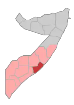 Location in Southern Somalia. | |
| Coordinates: 6°6′47″N 47°59′17″E | |
| Country | |
| State | |
| Capital | Jowhar |
| Government | |
| • Governor | Ahmed Meyere Makaran[1] |
| Time zone | UTC+3 (EAT) |
| HDI (2017) | 0.303[2] low · 12th |
Overview
It is bordered by the Somali regions of Galguduud, Hiran, Lower Shabelle (Shabellaha Hoose), and Banaadir, as well as the Somali Sea.
As part of the former Benadir region, Middle Shabelle's capital was Mogadishu up until the mid-1980s, when the town of Jowhar became the capital. It is named after the Shebelle River that passes through this region.
Middle Shabelle is principally inhabited by various sub-clans of the Somali Mudulood clan; most notably the Abgaal. Other Mudulood subclans that reside in the region include the Udeejeen, Moobleen and Hiilebi, who live alongside the Galje'l and Hawadle.[5] There are also members of the non-Somali ethnic minority Bantu group (Kaboole).
The region supports livestock production, rain-fed and gravity irrigated agriculture and fisheries, with an annual rainfall between 150 and 500 millimeters covering an area of approximately 60,000 square kilometers. It has a 400 km coastline on the Indian Ocean.[6]
Demographics
The majority clan in the region is the Abgal (Hawiye), but in spite of this majority, the region has suffered from “intense intra-clan conflict that has impoverished the region leading to a regional power struggle that divides the Abgal sub-clans. The two largest sub-clans are the Wa’buudhan (further divided into the Galmah and the Daud) and the Harti Abgal (further divided into the Agoonyar and the Warsangali). Other clans that live in the region include Galjecel, Jarer, Shiidle, Hawadle, Mubliin, Hilibi and other small tribes of Arab origin.
Districts
Middle Shabelle region consists of seven districts: Jowhar - the regional capital, Balad, Adale, Aden Yabal, Warseikh, Run-Nigrod and Mahaddey. The region supports livestock production, rain-fed and irrigated agriculture and fisheries, with an annual rainfall between 150 and 500 millimeters. Covering an area of approximately 60,000 square kilometres, the region has a 400 kilometre coastline on the Indian Ocean. The Shabelle river runs for 150 kilometres through the region.
[9]
Adale District
Adan Yabal District
Balad District
Jowhar District
References
- "News in Brief, 21st March 2014" (PDF). Embassy of The Federal Democratic Republic of Ethiopia. Archived from the original (PDF) on 14 July 2014. Retrieved 11 July 2014.
- "Sub-national HDI - Area Database - Global Data Lab". hdi.globaldatalab.org. Retrieved 13 September 2018.
- GeoNames Search
- "Somalia". The World Factbook. Langley, Virginia: Central Intelligence Agency. Retrieved 6 December 2013.
- https://www.berghof-foundation.org/fileadmin/redaktion/Publications/Other_Resources/Berghof_MS_Assessment_Report_Final.pdf
- http://www.pitt.edu/~ginie/somalia/pdf/mishabe.pdf
- "Somalia: Assessment report on the mechanisms and needs of the population living in Jowhar, Adale, and Adal Yabal, Warsheikh districts of Middle Shabelle region - Somalia". ReliefWeb. 19 June 2008. Retrieved 10 July 2019.
External links
| History |
|  | |||||||
|---|---|---|---|---|---|---|---|---|---|
| Geography |
| ||||||||
| Politics |
| ||||||||
| Economy | |||||||||
| Society |
| ||||||||
| |||||||||