Hollenback Township, Luzerne County, Pennsylvania
Hollenback Township is a township in Luzerne County, Pennsylvania, United States. The population was 1,196 at the 2010 census.[3]
Hollenback Township, Pennsylvania | |
|---|---|
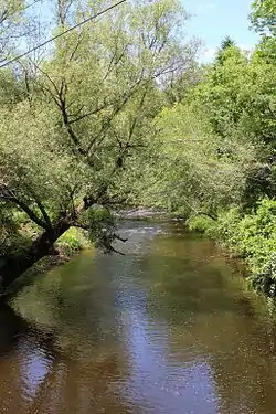 Big Wapwallopen Creek in Hollenback Township (June 2015) | |
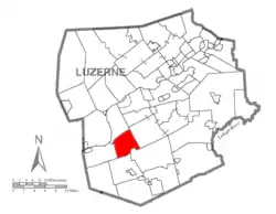 Map of Luzerne County highlighting Hollenback Township | |
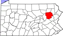 Map of Pennsylvania highlighting Luzerne County | |
| Country | United States |
| State | Pennsylvania |
| County | Luzerne |
| Area | |
| • Total | 15.16 sq mi (39.26 km2) |
| • Land | 15.16 sq mi (39.26 km2) |
| • Water | 0.00 sq mi (0.00 km2) |
| Population (2010) | |
| • Total | 1,196 |
| • Estimate (2016)[2] | 1,191 |
| • Density | 78.57/sq mi (30.34/km2) |
| Time zone | UTC-5 (Eastern (EST)) |
| • Summer (DST) | UTC-4 (EDT) |
| ZIP code | 18660 |
| Area code(s) | 570 Exchanges: 379,752,759 |
| FIPS code | 42-079-35192 |
History
Several German farmers entered modern-day Hollenback Township in 1789. They faced the difficult task of converting the rugged landscape and stubborn soil into fertile farmland. By 1796, the area belonged to Nescopeck and Newport Townships. In 1825, the first store and tavern were constructed.[4]
The logging industry took off in Hollenback; by 1866, the area contained six sawmills and several gristmills. By 1870, the township had a population of 1,300. It was later reduced to 730 when a section of the township broke away to form Conyngham Township.[5]
Geography
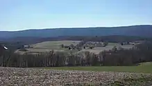
According to the United States Census Bureau, the township has a total area of 15.2 square miles (39.3 km2), all of it land. PA 93 travels through the southern portion of the township; it links up with I-80 just south of the municipality. I-81 is east of the township. Hollenback lies within a fertile valley between Hess Mountain (to the north) and Nescopeck Mountain (to the south). The center of the community is made up of small farming communities (e.g., the Hobbie Village). The northern and southern sections are made up of dense forests. Several creeks run through the township (e.g., Big Wapwallopen Creek and Little Wapwallopen Creek).
Education
Hollenback Township is part of Berwick Area School District.
Demographics
| Historical population | |||
|---|---|---|---|
| Census | Pop. | %± | |
| 2000 | 1,243 | — | |
| 2010 | 1,196 | −3.8% | |
| 2016 (est.) | 1,191 | [2] | −0.4% |
| U.S. Decennial Census[6] | |||
As of the census[7] of 2000, there were 1,243 people, 439 households, and 355 families residing in the township. The population density was 79.8 people per square mile (30.8/km2). There were 466 housing units at an average density of 29.9/sq mi (11.5/km2). The racial makeup of the township was 98.39% White, 0.32% African American, 0.08% Native American, 0.16% Asian, and 1.05% from two or more races. Hispanic or Latino of any race were 0.40% of the population.
There were 439 households, out of which 37.1% had children under the age of 18 living with them, 68.6% were married couples living together, 6.2% had a female householder with no husband present, and 19.1% were non-families. 15.9% of all households were made up of individuals, and 7.1% had someone living alone who was 65 years of age or older. The average household size was 2.80 and the average family size was 3.10.
In the township the population was spread out, with 26.3% under the age of 18, 6.5% from 18 to 24, 30.1% from 25 to 44, 23.1% from 45 to 64, and 14.0% who were 65 years of age or older. The median age was 38 years. For every 100 females, there were 99.8 males. For every 100 females age 18 and over, there were 97.4 males.
The median income for a household in the township was $42,063, and the median income for a family was $44,712. Males had a median income of $33,125 versus $21,058 for females. The per capita income for the township was $16,794. About 5.9% of families and 7.3% of the population were below the poverty line, including 13.2% of those under age 18 and 10.1% of those age 65 or over.
References
- "2016 U.S. Gazetteer Files". United States Census Bureau. Retrieved Aug 14, 2017.
- "Population and Housing Unit Estimates". Retrieved June 9, 2017.
- "Profile of General Population and Housing Characteristics: 2010 Demographic Profile Data (DP-1): Hollenback township, Luzerne County, Pennsylvania". United States Census Bureau. Retrieved April 17, 2012.
- http://www.usgwarchives.net/pa/luzerne/1893hist/hollenba.htm
- http://www.usgwarchives.net/pa/luzerne/1893hist/hollenba.htm
- "Census of Population and Housing". Census.gov. Retrieved June 4, 2016.
- "U.S. Census website". United States Census Bureau. Retrieved 2008-01-31.