Warrior Run, Pennsylvania
Warrior Run is a borough in Luzerne County, Pennsylvania, United States. The population was 584 at the 2010 census.[3]
Warrior Run, Pennsylvania | |
|---|---|
Borough | |
 Looking North on Academy Street in Warrior Run, Luzerne County, Pennsylvania | |
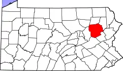
 Location of Warrior Run in Luzerne County, Pennsylvania. | |
 Warrior Run Location of Warrior Run in Luzerne County, Pennsylvania.  Warrior Run Warrior Run (the United States) | |
| Coordinates: 41°11′15″N 75°57′09″W | |
| Country | United States |
| State | Pennsylvania |
| County | Luzerne |
| Incorporated | 1895 |
| Government | |
| • Type | Borough Council |
| • Mayor | Tom Shypulefski |
| Area | |
| • Total | 0.66 sq mi (1.71 km2) |
| • Land | 0.66 sq mi (1.71 km2) |
| • Water | 0.00 sq mi (0.00 km2) |
| Elevation | 665 ft (203 m) |
| Population (2010) | |
| • Total | 584 |
| • Estimate (2019)[2] | 581 |
| • Density | 880.30/sq mi (339.70/km2) |
| Time zone | UTC-5 (Eastern (EST)) |
| • Summer (DST) | UTC-4 (EDT) |
| Zip code | 18706 |
| Area code(s) | 570 |
| FIPS code | 42-81080 |
History

Early history
The first settlers of Warrior Run were Connecticut Yankees Elisha and Anna Blackman and their young children Henry and Ebenezer. In 1791, they cleared trees and built a log cabin.
Coal mining
Coal mining was the chief industry in the region. In 1864, the Warrior Run Mining Company was organized; it reopened the old Holland and Hillman mine. The company constructed a breaker at the foot of the mountain which opened in 1867. At about the same time, both the Lehigh Valley Railroad and the Nanticoke Branch of the Central Railroad of New Jersey completed their lines through the area, thus making it possible to conveniently mine, transport, and market the area's coal. Ultimately, in the 20th century, the coal industry in the region died out.
Geography
Warrior Run is located at 41°11′15″N 75°57′9″W (41.187463, -75.952584) — just southeast of Nanticoke.[5]
According to the United States Census Bureau, the borough has a total area of 0.73 square miles (1.9 km2), all of it land. The northern and western sections of the community consist mostly of homes and businesses; the southern and eastern part of the borough is predominantly woodland.
Demographics
| Historical population | |||
|---|---|---|---|
| Census | Pop. | %± | |
| 1900 | 965 | — | |
| 1910 | 1,251 | 29.6% | |
| 1920 | 1,387 | 10.9% | |
| 1930 | 1,516 | 9.3% | |
| 1940 | 1,339 | −11.7% | |
| 1950 | 1,056 | −21.1% | |
| 1960 | 833 | −21.1% | |
| 1970 | 816 | −2.0% | |
| 1980 | 784 | −3.9% | |
| 1990 | 656 | −16.3% | |
| 2000 | 624 | −4.9% | |
| 2010 | 584 | −6.4% | |
| 2019 (est.) | 581 | [2] | −0.5% |
| Sources:[6][7][8] | |||
As of the census[7] of 2000, there were 624 people, 257 households, and 178 families living in the borough. The population density was 806.2 people per square mile (312.9/km2). There were 285 housing units at an average density of 368.2 per square mile (142.9/km2). The racial makeup of the borough was 98.88% White, 0.32% African American, 0.16% Asian, and 0.64% from two or more races. Hispanic or Latino of any race were 0.80% of the population. The borough is also located on a historical battleground and mostly around fertile soil.
There were 257 households, out of which 26.5% had children under the age of 18 living with them, 51.0% were married couples living together, 16.0% had a female householder with no husband present, and 30.7% were non-families. 25.7% of all households were made up of individuals, and 13.6% had someone living alone who was 65 years of age or older. The average household size was 2.43 and the average family size was 2.94.
In the borough the population was spread out, with 22.6% under the age of 18, 6.1% from 18 to 24, 28.5% from 25 to 44, 24.7% from 45 to 64, and 18.1% who were 65 years of age or older. The median age was 40 years. For every 100 females there were 86.3 males. For every 100 females age 18 and over, there were 82.3 males.
The median income for a household in the borough was $29,583, and the median income for a family was $36,250. Males had a median income of $28,958 versus $21,304 for females. The per capita income for the borough was $15,693. About 10.0% of families and 9.1% of the population were below the poverty line, including 12.2% of those under age 18 and 9.8% of those age 65 or over.
References
- "2019 U.S. Gazetteer Files". United States Census Bureau. Retrieved July 28, 2020.
- "Population and Housing Unit Estimates". United States Census Bureau. May 24, 2020. Retrieved May 27, 2020.
- "Profile of General Population and Housing Characteristics: 2010 Demographic Profile Data (DP-1): Warrior Run borough, Pennsylvania". United States Census Bureau. Retrieved April 13, 2012.
- "A History of Warrior Run Borough".
- "US Gazetteer files: 2010, 2000, and 1990". United States Census Bureau. 2011-02-12. Retrieved 2011-04-23.
- "Census of Population and Housing". U.S. Census Bureau. Retrieved 11 December 2013.
- "U.S. Census website". United States Census Bureau. Retrieved 2008-01-31.
- "Incorporated Places and Minor Civil Divisions Datasets: Subcounty Resident Population Estimates: April 1, 2010 to July 1, 2012". Population Estimates. U.S. Census Bureau. Archived from the original on 17 June 2013. Retrieved 11 December 2013.